I took this photo this morning:
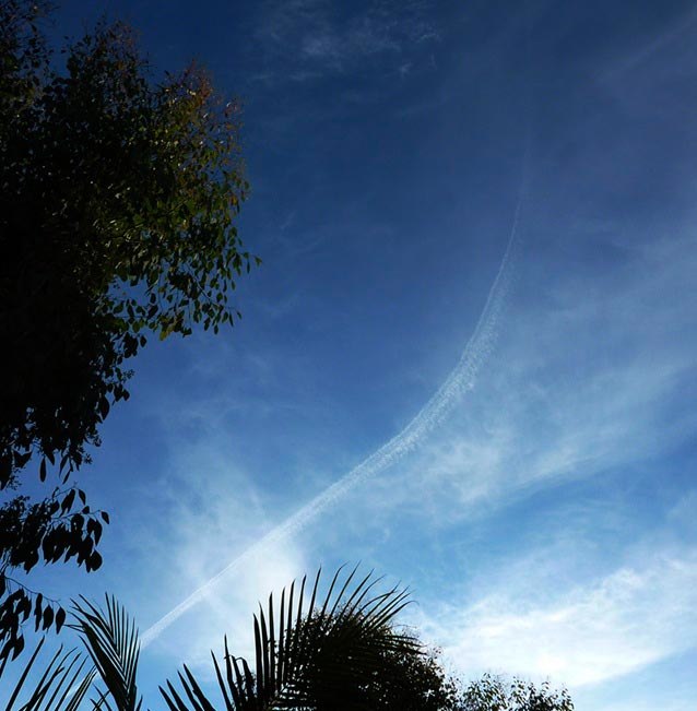
It’s an interesting contrail as most trails you see are straight lines, planes generally fly directly from one place to another. This plane was flying in a south east direction. After making this left turn it made a right turn to continue roughly in the same direction as before.
I realised this would make a quite distinctive track on FlightAware, so I went inside to have a look and found this:
![]()
You can see it’s an Air Mexico 737, flight AMX665, from San Francisco (KSFO) to Mexico City (MMMX), flying at 37,000 feet and 437 knots.
I then checked the temperature aloft, San Diego is the closest:
http://www.usairnet.com/cgi-bin/Winds/Aloft.cgi?location=SAN&Submit=Get+Forecast&hour=06&course=azimuth
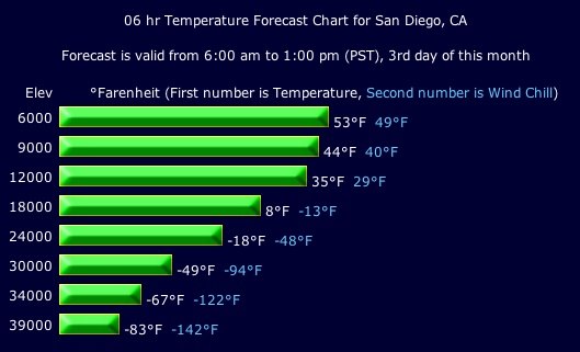
Looks like about -75F forcast at 37,000 feet (11,277 meters).
What about relative humidity with respect to ice? That needs to be above 100% for contrails to last, that means, approximately, a relative humidity of above 70%. Unfortunately there’s no way of knowing what the humidity is at that level and at that time, as it’s only measured twice a day at stations hundreds of miles apart: these stations:
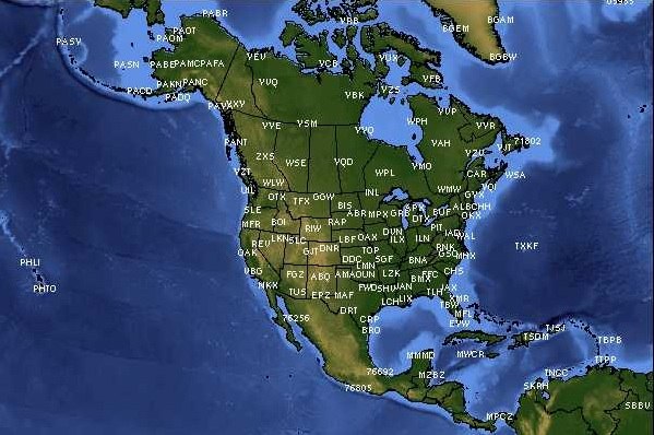
The two closest to here (the West Side of of Los Angeles) are VBG (Vandenburg AFB, 130 Miles North West) and NKX (San Diego, 110 miles South East). Both stations send up a sounding balloon at 00Z (4PM the previous day for us) and 12Z (4AM). We have today’s 4AM sounding here for VBG and NKX
Here’s the results for around 11,000m:
72393 VBG Vandenberg Afb Observations at 12Z 03 Jan 2010
 -----------------------------------------------------------------------------
   PRES   HGHT   TEMP   DWPT   RELH   MIXR   DRCT   SKNT   THTA   THTE   THTV
    hPa     m      C      C      %    g/kg    deg   knot     K      K      K
-----------------------------------------------------------------------------
  361.0   8153  -34.9  -37.3     79   0.43    271     26  318.8  320.4  318.8
  341.4   8534  -38.2  -40.4     80   0.33    280     27  319.4  320.6  319.4
  326.6   8839  -40.9  -43.0     80   0.27    260     32  319.8  320.8  319.8
  320.0   8978  -42.1  -44.1     81   0.24    262     32  320.0  320.9  320.0
  312.2   9144  -43.4  -45.7     78   0.21    265     32  320.4  321.2  320.4
  300.0   9410  -45.5  -48.3     73   0.16    265     27  321.1  321.8  321.1
  298.2   9449  -45.8  -48.6     73   0.16    270     27  321.2  321.8  321.2
  271.0  10080  -51.1  -53.5     75   0.10    267     35  322.4  322.9  322.5
  250.0  10600  -55.3  -59.5     59   0.05    265     42  323.7  323.9  323.7
  235.7  10973  -58.1  -62.9     55   0.03    260     46  324.9  325.1  324.9
  231.0  11100  -59.1  -64.0     53   0.03    264     43  325.3  325.5  325.4
  213.7  11582  -62.9  -67.2     55   0.02    280     29  326.8  326.9  326.8
  203.4  11887  -65.3  -69.3     57   0.02    290     33  327.6  327.7  327.6
  200.0  11990  -66.1  -70.0     58   0.02    290     32  327.9  328.0  327.9
  194.0  12175  -67.3  -70.3     66   0.02    280     31  328.9  328.9  328.9
  193.4  12192  -67.3  -70.3     65   0.02    280     31  329.2  329.2  329.2
So for contrails we need below -40C and 70% relative humidity. This seems quite reasonable based on these figures, very good contrail conditions from 8839 to 10080 meters (29,000 to 33,000 feet), marginal up to 12,192 meters (40,000 feet).
It’s interesting that between 10080 and 10600 meters (33,000 and 34,776 feet) the humidity changes from 75 to 59, all within 2000 feet. That quite clearly demonstrates why you can can sometimes see two planes at apparently the same height, and they leave very different contrails.
Note that this set of readings was taken four hours before the photo, and 130 miles away, but it’s the best info we have available. Obviously the local reading will differ somewhat.
Glad to see you are still at it!……. =)
Identifying a curved chemical disperal of aerosol material would be a more appropriate name for this page.
Ian, I’m assuming that by “chemical” you mean it contains more than just exhaust gasses and water vapor. If so, how are you able to identify this contrail as being a chemical dispersal? Thanks.
Hmm, apparently nobody has considered the science in condensation of materials at high altitude. If you really want to learn what this is, please see http://www.carnicom.com
Start looking at my YouTube videos and you can see aircraft flying below and above us with different contrail lengths. It’s all about relative humidity.
http://www.youtube.com/user/wineandflyguy#p/a/u/2/JmtGc_-t3jg
http://www.youtube.com/user/wineandflyguy#p/u/3/ZFWD8gvH0ZA
Some great videos there (yeah, I’m kinda ashamed to admit that).
Unfortunately I can only imagine what your videos will be edited into. I wouldn’t be surprised to see them crop up in “chemtrails exist!!!!” videos. I can see people making out you’re a concerned pilot who has started videoing this phenomena in an attempt to let the public know that they are being sprayed.
I also appreciate that there isn’t anything in those videos that would convince anyone either way, really. Unless you can point to a specific one you think proves anything outright.
Looks fantastic up there. One thing that strikes me is how on earth people can imagine that pilots haven’t noticed this going on.
I am ultimately amazed at the lack of chemtrail comments in most of the videos.
Is this a normal contrail?
http://www.youtube.com/watch?v=zhcP-qh-oXk
I believe that’s a roll cloud. Nothing to do with aircraft.
It’s a cloud. See:
http://www.youtube.com/results?search_query=morning+glory+cloud&search_type=&aq=f
xD awesome.
I’m sure you’re aware but the most common form of a curve is due to the fact that all modern avionics systems “lead’ the turn for navaids in order to stay within the boundries of the airway. There’s a huge complexity to why flight directors lead turns. Would you like me to elaborate? (we can’t physically fly precise angles obviously but it goes further than that)
I am interested in how the path ends up as it does. In this situation, over SoCal LA area, would this guy be flying VOR radials, or just doing a VOR based airway with GPS?
It looks like he’s inbound on a LAX VOR, then either he’s simply being moved by ATC, or when he gets over the LAX VOR he transitions to another, like Oceanside?
I’m afraid I’ve not done much VOR navigation. And I’ve no idea how the nav works at 30,000+
Nav at 30000+ is the same at 5000- the only difference is our speed, and at altitude (with winds) our speeds may be upwards of 500 kts groundspeed so you can imagine that our radii for a turn could be enormous! By the way- our FMSs combine GPS and ground based navaids seemlessly behind the scenes so Navigation is all “imaginary”. Does that make sense? We rarely nav based on VORs alone unless it’s involved in an approach. Man I could really inform you on sooooo much I don;t know where to begin!!!! I hope i can help your cause- especially as someone who is CONSTANTLY “chemtrailing” all over the nation!! Straight from the horses mouth huh?!
Sorry- I never answered the question. After the straight line ends the pilot is obviously on on a visual and flies the plane wherever he wants for the aproach. It could be any curve or straight line or anything. There is NO SUCH THING as NORMAL flight patterns! It’s a sky- we can go anywhere.
When flying from a given point TO a given point (MPLS to LA for example) is there a “normal” pathway that most airplanes flying that route follow for the majority of the trip? Pending weather of course.
I hope that question makes sense, it looks kinda cryptic when I read it to myself lol.
captfitch, have you even been in a high altitude hold and flow through your own contrails? I’m specifically thinking of things like:
https://contrailscience.com/racetrack-contrails/
That’s a pretty rare contrail pattern, so I was wondering if such holds actually happen to regular traffic – or would it most likely be training/testing/military?
Suntour- It’s rather complex but the short answer is no.
Let me start by saying that with very few exeptions you can fly from point A to Point B ten times and never fly the exact same route. Obviously the longer the route the more possibility for variance but the same holds true for short routes as well.
It’s really too complex to get into but the bottom line is this- NEVER let a chemtrailer tell you about “normal” traffic patterns. If you told me I was going to fly from NY to LA I can tell you what I would like to fly and what I might expect to fly but I could never tell you what my route will eventually be.
Uncinus- Again, very complicated but yes, I have flown through my own contrail.
Here’s the problem with this scenario and why it’s rare: As you know by now persistant contrails typically occur in advance of some upper level system that will bring bad weather to an area. The weather under persistant contrails is usually nice so traffic into and out of those airports is usually not backed up. We almost NEVER hold at altitude but here is when you might do it: In the summer there are often squall lines three or four hundred miles in advance of a cold front associated with an upper and lower level low. These lows pump moisture high into the atmosphere, causing contrails. If the squall is slow-moving (usually in mid summer) the line may take hours to pass through an area like DFW. We may be inbound to DFW and the squall may back up traffic far enough west to get into an area condusive to contrail formation and we may be high enough stil to make them in our holds. (these holds could last for an hour and we may do 8 or 9 turns around the holding fix) The ones that can fly high are held up high to make room in the stack for those that can’t, so the stack may be twenty-thousand feet high with twenty planes in it.
So here we are in the hold making all sorts of persistant contrails but ther is one more problem. What the CTs claim to see sometimes is the “chemtrails” dripping or falling. They ARE! Anything we produce is pushed down because of Newtons 2nd or 3rd law (I forget). They initially fall at about 1000 feet per minute and then slow to a stop after about ten minutes. So by the time you make it all the way around to where you’ve been the trail you made earlier has fallen out of your path. ONLY if you descend IN the hold can you fly through you’re own path. BUT- they usually turn you out of the hold before they let you descend so you don;t hit anyone below you in the stack. So you see it’s rare- but I have done it.
Another thing, holds are usually predicated to some degree on what the pilot wants. It may show on the map one way but if we prefer to hold with left-hand turns instead of right they can let us. And if we want to hold in ten mile legs instead of minutes we can usually. It’s up to ATC to let us and they usually do. Again- there is NO SUCH THING as NORMAL traffic patterns.
Next question?
What are some of the factors that would cause flights from A to B to be different each time? I imagine weather would be one factor, is that random enough to cause each flight to be slightly different or are there other factors?
Thought of something else- sorry. Something else we do in holds almost ALWAYS is pull the power back so we can conserve fuel going essentially no where. The EGTs may be very low (450 C?). Could hinder contrail formation. I think the day I flew through my own trail we had been holding at .80 to burn off some fuel so we could land light at a shorter field if we had to devert. High speed= high power settings= high EGTs=contrails?
Suntour-
Like I said- it’s complex.
Here’s an example:
If I need to go from DFW to HOU I start by planning. There are at least two or three different departure procedures (DPs) I can choose from to leave DFW. They terminate at several points that are in the direction of HOU. HOU has at least three arrivals that begin around the DFW area. I can pick one of those and connect it with the departure from DFW. Now I have a full route that I trhow into the ATC computer. But the ATC computer looks at my route and either likes it and keeps it or gives me something totally different (or slightly different) and now I’m expected to plug that into my plane and fly it. The ATC computer knows everyone who wants to fly anywhere near your route and adjusts those routes to a degree to provide the smoothest flow. Controllers can intervene at any point and change that route before or DURING the flight to suit thier needs.
Additionally after I’m in the air the sky is literally the limit. We can move left and right, up and down for many reasons (weather, traffic, better rides, better winds) OR JUST BECAUSE WE FEEL LIKE IT!!
And yes- i would say that with a few exeptions (like very deep into an arrival or on a very popular route like J6 that runs back and forth to the East Coast) that there are soo many variables that virtually every flight will vary with some degree even more than slightly.
Wow, interesting stuff, thanks for the information! I’ll try to think of some more questions.
Yes. Thanks, captfitch. 🙂
And here it is -> http://www.youtube.com/watch?v=9yrj_NTP2Vw
Recognise any of those videos, captfitch? Not saying they’re yours, although there might be a bit in there.
Nope- not mine. I really couldn’t tape anything in flight because our aircraft don’t have cockpit doors so the passengers would probably be upset that I wasn’t flying the plane. Boy would I like to- there’s been some things I’ve seen that would make some good videos. Just not good chemtrail videos.
Just curious. I have observed multiple aircraft flying at around the same altitude at the same time. One aircraft behind the other. I noticed that one aircraft’s contrail did not dissipate while the other two did.
What could be the reason behind that phenomena?
Max Factor said:
“What could be the reason behind that phenomena?”
The probable reasons are discussed elsewhere on this site:
https://contrailscience.com/why-do-some-planes-leave-long-trails-but-others-dont/
Since I started watching contrails regularly, I have observed the same many times. Persistent contrails are formed in the area of very high relative humidity that is limited both vertically and horizontally. The other planes probably have flown outside this area or above or below it.
Captfifch, i thought cockpit doors were pretty much standard, especially post 9/11.
As a rule, if the corporate aircraft has a door,it is always open. unless the passenger specifically asks for it to be closed. Most corporate aircraft do not have cockpit doors.