There’s a great new series on the BBC in the UK: Britain From Above, that shows how various things look from a high perspective, using very interesting visualization techniques.
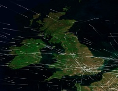
One of the most interesting (for me) was an episode that showed all the air traffic in UK airspace in a 24 hour period. That involved mapping the positions of 7,500 aircraft, showing how they crisscross the UK:

Here’s a video:
This is just part of them, captured midway through the day. But it’s interesting to see the width of the paths they fly along – particulalrly those that fly over London to Manchester and Scotland. It’s also very interesting to see the area where paths cross. These would very obviously give rise to the to contrail “grids” that some people feel are so suspicious.
Britain has nothing like the amount of traffic that the US has. According to the National Air Traffic Controllers Association:
On any given day, more than 87,000 flights are in the skies in the United States. Only one-third are commercial carriers, like American, United or Southwest. On an average day, air traffic controllers handle 28,537 commercial flights (major and regional airlines), 27,178 general aviation flights (private planes), 24,548 air taxi flights (planes for hire), 5,260 military flights and 2,148 air cargo flights (Federal Express, UPS, etc.). At any given moment, roughly 5,000 planes are in the skies above the United States. In one year, controllers handle an average of 64 million takeoffs and landings.

Here you can make out the shape of the US purely from the flight paths. You can see the major cities, and the air links between them. You can also see that there is really nowhere in the US where you don’t have commercial flights flying over you. Even more, there’s hardly anywhere where you don’t have two or more flight routes intersecting near you.
For an interactive look at this data, see:
So it’s no surprise that in regions where the weather is right for contrails to persist, then you’ll see some kind of “grid”, or intersecting contrails in the sky, like this:


This is a screenshot of the Dutch (Schiphol) ATC radar:
http://b.imagehost.org/0587/ATC2.png
It is quite busy in the sky!
There is a civil aviation navigating beacon a few miles from where I live. I can often see this grid pattern emerging right overhead this beacon. Sometimes I can even see westbound planes creating contrails, and eastbound planes that don’t. This is because the westbound planes need to fly 2000 feet higher over the beacon than eastbound ones.
Nice, great info Wickid!
Wickid:
With the increasing accuracy of instrumentation, this has been reduced to 1000 feet.
Personally I find this to be uncomfortably close, considering that the typical forward speed of cruising aircraft is 800 feet per second. A sneeze might put you where you might earnestly NOT wish to be….
Or someone else might make your mistake for you:
http://www.youtube.com/watch?v=0KWvtIsQ-Ck
Although these images are stunning from an artistic perspective, its shocking to realise how much we are killing the planet.
Nymph:
To realise how much we are killing the planet perhaps it might be better to research the species extinction rates, the man-made pollution of our water cycle, the ground-based man-made pollution of our atmosphere that causes both global warming and global dimming, than infer mass extinction by water ice trails that are both formed from, and evaporate back into, the atmosphere.
The net effect of contrails is generally thought to increase nighttime temperatures and reduce daytime temperatures by the same amount – so it is roughly zero over time. It just makes for more boring skies…
…but these skies are local skies, local to where trails are. Seen from space, it’s the weather systems of the Earth that predominate, to the extent that the global effect of aircraft contrails is too insignificant to be measurable using even today’s satellite-based technology.
Amazing video! Really beautiful =]
Thanks for posting
I think the traffic is only in the land. But it’s interesting to see the width of the paths they fly along – particulalrly those that fly over London to Manchester and Scotland. Nice photos.
Can you give the source link for the image above….the colourful US flight traffic image.
Thanks. I’ve seen the link to the artist somewhere on here….but can’t remember where.
http://www.aaronkoblin.com/work/flightpatterns/
The contrails is not “normal”
When you see a commercial flight over head of you do you see contrails like that in sky?
These flights must be flying lower then commercial flights to get contrails like that.
Looks more like crop dusting to me.
Notice the plane is totally white. Nothing to identify it.
[img]https://contrailscience.com/wp-content/uploads/Screen shot 2011-08-23 at 1.07.57 AM.png[/img]
Chris,
this is a perfectly normal contrail for a four-engine jet, I’ve seen a lot of them from the ground. Here is an example:
[img]https://contrailscience.com/wp-content/uploads/P1010794c.jpg[/img]
The four trails begin to merge at some distance behind the plane.
There are Google watermarks in your screenshot, suggesting it has come from Google Earth (or Google Maps). Could you post the coordinates of this place? I’d like to see a larger picture.
It also suggests that this is a composite image, made of several aerial (or satellite) photographs focused at different distances. It explains the second image of the same plane, which is offset and out of focus.
Commercial aircrafts usually have no distinct marking on the top of fuselage and wings, so it is not surprising that no identifiable features can be seen in the photograph. Also, there are miles of air between the camera and the plane, so the plane looks white in the same way as it does from the ground.
Indeed, very few planes have marking on the top. Not even that many underneath. It’s mostly on the sides.
That plane in the Google Earth image actually appears to have a dark tail, and some logo type on the front left. A bit like this:
But from far above, this is going to look just white.
But even “all white” aircraft are not actually suspicious – ther are a lot of them around. They are sometimes aircraft produced without an order so have no airline markings, or alternatively are older aircraft that are operated by charter companies for various purposes.
One “infamous” onne is a 767 tanker leased to the Italian airforce so they could start training before getting new ones from Boeing – Tankerenemy has a video about it on YT – but that aircraft does have the required registration marks – but aircraft registration marks are generally only 1 ft (300mm) tall, and the numbers and letters that make them up only 2″ thick – they are not there to identify a/c from miles away as some peole seem to believe – only to identify the a/c when you are actually at it!
Identification of a/c in flight these days is mainly electronic via systems such as ADS-B and the like, and you can see the information on sites such as Flight Tracker (http://www.flightradar24.com/ – which isn’t radar desite it’s URL!) and Flight Aware (http://flightaware.com/live/)
Hi Alexey,
I found that plane in the country of Georgia just south of Kulevi, Georgia. I took a screen shot of it which is why you see google watermarks on it. I don’t know the coordinates or I would give it to you. But just scroll down a little from Kulevi and you should see it I hope.
The reason I felt like I was expecting to see some kind of mark on the aircraft is because I most of the time do see markings on the craft from google maps. Like this one for example which is obviously not all white. You can tell it is from United Airlines.
[img]https://contrailscience.com/wp-content/uploads/Screen shot 2011-08-23 at 6.33.56 PM.png[/img]
I used to live in Honolulu, Hawaii where I lived near Pearl Harbor. I don’t remember ever seeing a totally white military aircraft (or aircraft of any kind and they would fly over my house every day). They were mostly some shade of grey. Though that is not to say they are not around.
Also what I don’t ever remember seeing was seeing contrail’s when the flights were coming in for a landing, and even when they were still far out to sea high in the air. I now live in Orlando, Florida where I live about 45 minutes away from the airport. I also live right underneath a path for planes. But they are still very high up when starting to come in for a landing (I can see that they are flying to the direction of the airport) and also I never seen contrail’s from them. If that did happen where contrail’s would form when the weather would have the right conditions for that, then I would have a very cloudy sky above me, but again it never happens.
When I do see contrail’s they seem to happen all on certain days (and if the sky is filled with them then I have noticed it has made the sky slightly cloudy) and most of times do a “grid” of some kind and they happen in places that I never see flights cross (only on the chemtrails days, but again that is not to say that they don’t fly over that area, maybe I just don’t see them . Which is why I know that contrail’s are not “perfectly normal” or we would be seeing them from planes much more often then we do.
Anyways there is much information on chemtrails if you would like to do some research (just type it in on youtube. I am not saying it is true – I just keep an open mind)
Thank you for the flight radar Mike. I have used it before when a friend was coming to the US from out of country. It was cool to see the flight getting closer, ever so slowly.
I would take most of the chemtrail promoting videos on YouTube with more than a grain of salt.
Many videos don’t show anything worth mentioning except, well, contrails, probably with some dark music and a context of “This can’t be natural!”.
Others copy/paste material that has been long debunked or keep repeating claims known to be just plain wrong. I think the better part of those are discussed somewhere on this site.
Later you said:
“When I do see contrail’s they seem to happen all on certain days (and if the sky is filled with them then I have noticed it has made the sky slightly cloudy)”
Your observation of the two things and their connection is entirely correct – but why are you so certain about cause and effect here?
If you look at it the other way round – keeping your openness – it makes sense as well, doesn’t it?
The humidity of the air in high altitude increases up to saturation and condensation, and as a consequence a thin cloud layer is appearing. Now any plane crossing that area will show a persistant or spreading contrail because the conditions don’t allow it to dissolve.
One thing among many that can contribute to such a change in the higher levels is an approaching front which lifts up air from lower levels, cooling it down and thus increasing the relative humidity, bringing it closer to the point of condensation.
Hi Chris,
Thank you for the info, I have found the place. The image covers a ground area of 10×10 square miles. It would take about one minute of the jet flight to cross it, therefore the contrail in the image is pretty young. The coordinates of the plane are: 42°14’37” N 41°38’57” E. In Google Earth, the cursor coordinates appear in the bottom line under the window. In the same line, there is also the date when the image was taken: 5/27/2005. The estimated time (deduced from the sun azimuth of 140°) is about 8 AM UTC = 12 noon local time. The sun elevation for this place at the date and time is about 65°.
The contrail casts a distinct shadow on the ground that runs parallel to it at some distance. Measured along the sun azimuth, the distance is about 3.2 km, that gives the plane altitude being about 7km (23 000 ft), or about two thirds of a typical cruise altitude of commercial jets. As the plane is about to clear the Georgian airspace, heading across the Black Sea toward Europe, this suggests that it probably is still ascending after having taken off from a local Georgian airport, most likely in the capital Tbilisi, or the second largest Georgian city Kutaisi. These are not very busy airports; if there were records of outgoing flights on that date, it would be possible to narrow down the most likely flight(s).
For even bigger picture, you can also check MODIS satellite images of the area on that day: http://lance-modis.eosdis.nasa.gov/imagery/subsets/?project=&subset=Azerbaijan&date=05%2F27%2F2005, to see what was the weather around and how it was changing over time. The Terra image had been taken at 7:35 UTC, shortly before the google Earth image; whereas the Aqua image about three hours later, at 10:50 UTC.
As for the image of United plane over Chicago, it actually proves my point. It is all white apart the tail, which is seen at angle. I think that Google Earth identifies the plane not by this feature, but probably by matching its space and time coordinates to archived flight tracker data. Also, to see that the most planes indeed look white from above, there is no need to look for their images in flight in Google Earth. Look at the image of any international airport, there are always plenty of planes on the ground.
I have to correct myself on two points in the previous comment.
1. Google do not identify occasional planes on the Google Earth images, it has been done by a third party, e.g. Google Earth Hacks:
http://www.gearthhacks.com/dlfile32084/Boeing-747-with-contrails-over-Georgia.htm
http://www.gearthhacks.com/dlfile30599/Over-Chicago.htm
2. The resolution of the United plane over Chicago image is quite high, zooming at it in Google Earth reveals the United livery:
[img]https://contrailscience.com/wp-content/uploads/United_Chicago.jpg[/img]
As for the above image of the plane over the country of Georgia (Chris, August 22, 2011 at 10:09 pm), its dimensions and proportions match well those of Boeing 747-400:
[img]https://contrailscience.com/wp-content/uploads/B747-400_Georgia.jpg[/img]
In addition to this, the knowns about this particular flight include the exact date and place and estimated time and altitude. Unfortunately, as it happened more than six yes ago, there are not enough records available in public domain to identify it. If, as the estimated altitude of 23,000 ft suggests, it originated from a local Georgian airport, then it the most likely was a charter flight. There are no passenger flights by this type of plane to/from any Georgian airport yet, whereas regular cargo flights in the area started well after the date of this flight (May 27, 2005; note that the former US president G.W. Bush visited Georgia earlier that month).
i had asinken wish to see london from sky. but you failed to supply picture. i am agovt. official in bangladesh in the mtntstry of industry.sorry failed to see the video
“Britain has nothing like the amount of traffic that the US has”.
This is true. However, to be clear on things, London Heathrow handles the same amount of traffic on its TWO runways as Denver can handle with SEVEN, US cities are thousands of miles apart from each other rather than dozens (maybe hundreds) of miles apart in the UK, and the US is 40x the size of the UK whilst the US handles twelve times as much air traffic. On a flight-per-sq-mile metric, the skies around London and the southeast of England are some of the most complex in the world. And this chemtrail nonsense? Total bollocks. Look up the word “bollocks” if you like.