UK resident UnionJack1967 recently posted some photos on DavidIcke.com of five very unusual looking trails. He took several photos, and I’ve combined two of them here to show all five trails together.

He provided the following information about the trails:
Being a bit of an aircraft buff, i know enough about contrails to know one when i see one, but seeing these pictures, i can say that these are no contrails, quite what they are i am uncertain, but they are definately not contrails, not in this configuration!
Taken with iphone @ approx 1800hrs, 8th apr 2011, location – 8 miles south of Birmingham UK
These are indeed very odd looking trails. Short contrails are not uncommon, they are typically formed when a plane flies through a region of air that’s moist and cold enough to support contrail formation, and sometimes persistence. But that type of short contrail is generally of consistent thickness, and parallel trails in the same general area of the sky should start and stop in a way that roughly lines up. UnionJack1967’s trails are an unusual tapered shape, and their ends seem oddly random, very different to what you would expect.
Initially, I was inclined to think they were not contrails at all – perhaps some kind of smoke trails, maybe skywriting practice, but that made little sense either. Then I was suddenly reminded of a somewhat similar looking short trail caused by an aircraft – a fallstreak cloud:

Fall streaks like these are caused when a plane is climbing or descending through a thin layer of supercooled cloud. The passage of the jet caused the cloud to precipitate out as ice crystals, leaving a round hole, and a central cloud, essentially of falling high altitude snow. Note how this trail also seems to taper towards the lower right.
But that’s not what is going on in the UnionJack1967 photos. But I think it’s something similar – planes are descending or climbing through a relatively thin layer of moisture. This layer supports the formation of contrails. Since the routes that planes fly along are a few miles wide, and their descents can vary, then the start and end positions are going to be pretty random, as seen in the photo.
The tapered nature of the trails is a bit odd. But I think what’s going on is that the higher up the trail is, the more it will have the chance to expand during its initial descent. The parts of the trail that are closest to the bottom of the layer will be thinnest, as part of the contrail will descend below the bottom of the layer before it has a chance to fully spread. If this theory is correct then the thinner end of the contrail should point towards the nearby airport that the plane took off from (or is descending towards).
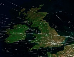
The photos were taken near Birmingham in the UK, in the evening, and it seems like the sun is roughly to the right of the photos, which means the thin end of the trails is roughly pointing south – towards London.
This hypothesis is confirmed to some extent if we look at the Aqua satellite photo for that day:
http://rapidfire.sci.gsfc.nasa.gov/subsets/?subset=United_Kingdom_Ireland.2011098

The central portion of the image was taken at 12:50 UTC, so at 1:50 PM, BST, about four hours before UnionJack1967 took his photos. You can see an approaching band of cirrus level clouds in the West. And if we zoom in on the South Wales area indicated above:

We see three very similar short trails, with the thinner end pointing roughly towards London. You can tell they are very high by looking at the distance of the trail from the shadow it casts. The two longer trails are about ten miles long each. Given that UK weather systems generally move towards the east, it seems pretty reasonable that the conditions above South Wales in the 1:50 image would have migrated over to Birmingham a few hours later.
UnionJack1967’s trails look very odd because they combine an unusual grouping of trails with an unusual kind of tapered trail. Had there been a single tapered trail like this, or a group of five trails, then it might not have raised any interest. But the perfect weather conditions for creating this type of trail let to five appearing at once, which looks odd.
I feel fairly confident that the above explanation is the most likely one – but would welcome suggestions for what else might cause trails like this.
It’s not unusual for the short non-persistent contrail behind a plane to be tapered, of course – what’s unusual is for a persistent contrail to be tapered.
Scientifically sound, and makes logical sense.
Also, I can’t really see how this would fit into any of the existing ‘chemtrail’ theories. It’s just another interesting peek into the (mostly) invisible subtle variations in our atmosphere.
It’s a curious thing that unusual cloud or contrail formations are viewed as evidence of a widespread constant operation.
If it were widespread, then the manifestations would not be unusual – you’d see them all the time.
Estimated lengths of the tapered contrails in the UJ’s photos are 3-5 km, that is, 3-5 times shorter than the short trails in the Aqua satellite image. Also, it is less likely that the atmospheric conditions above Bristol channel have migrated over to Birmingham in a few hours on the day. On 8th April and the following weekend, the unseasonally warm weather in England was dominated by high atmospheric pressure in the South. I was traveling that day across the country from East to West and back, passing around Birmingham twice, the sky was clear all the way. The conditions above Birmingham probably were of “local” inland origin.
I’ve noted before that in certain conditions contrails can spread out rapidly, in a matter of minutes rather than hours. The expansion rate probably depends on the concentration of excess vapor. The higher the concentration above the ice-saturation value, the faster is contrail spreading. The tapered shape is probably due to a gradient of supersaturation along the trail, with the highest value being at the wider end.
[img]https://contrailscience.com/wp-content/uploads/P1030126.JPG[/img]
Here, for example, is my recent photo of the contrails crossing the edge of a cirrus cloud. They are wider on the outside and go to some distance beyond the edge, presumably to the border of a supersaturated area. Inside the cloud, where the excess vapor has already condensed, the contrails are thinner. Their tapered shapes are partly compensated by perspective, creating an illusion of the uniformly-wide contrails raining diagonally down to the ground.
I think that in the first case, there probably was a vertical gradient of supersaturation above Birmingham and the short tapered contrails were left by either climbing or descending planes. In the other case, the gradient of supersaturation above Bristol Channel might also have a horizontal component.
Whoa, cool post, and very interesting and unusual trails! I’d say those are definitely airplane contrails, as you can see the “double” nature of them as a result of the wing vortices. Unicus’ possible explanation makes good sense, too, with them being caused by a climb or descent through a relatively moist layer.
However I’d disagree with your explanation of the tapers, and instead I’m inclined to agree with Alexey that they’re probably tapered because of a supersaturation gradient, probably with altitude. So it becomes visible as the plane climbs or descends through the gradient. If that’s the case, the tapers would all be in the same direction, roughly, as the planes are climbing or descending from the same direction (that is, the low tapered side would be toward London and the higher non-tapered side would be pointing away from London, regardless of whether the plane was climbing or descending. For example). And we do see that in the pictures.
In any case, thanks for posting! Great pictures!
–NoJoe
Okay, the gradient sounds plausible. I wonder if there might even be an aspect of a temperature gradient, if the trails are, say, 20,000 feet long, then the plane could descend 1,000 to 2,000 feet. At the standard lapse rate of 3.5F/1000 feet, that could be 7 degrees fahrenheit. Enough to contribute to the slower ice growth.
I’m not entirely convinced though. Would higher ice supersaturation (and/or lower temperature) cause a trail that spreads out more? It would cause a denser trail, as ice crystals would grow quicker. But what’s the actual mechanism that cause the trail to be wider?
Look at the smaller trail on the right. It has pendules, which are caused by sinking air. Would not the apparent horizontal width of the trail also include a vertical component, and hence be reduced by the lower parts of the contrail not having as much cold/humid air to fall through? (Although of course if it’s the air itself that is falling, that’s also different from my original suggestion, as the contrail is being advected downwards, rather than precipitating).
Relevant here is this excellent video of a contrail that shows the shape. This particular one seems twice as tall as it is wide. That’s something you can’t see from most angles.
http://www.youtube.com/watch?v=9UHg3_qgmts&hd=1
See also:
http://www.youtube.com/watch?v=605ik6FM-o8&hd=1
and
http://www.youtube.com/watch?v=jP29NSAYI7c&feature=related&hd=1
Very interesting seeing the 3D shape of a somewhat aged contrail close up.
that first video looks very familiar. I hate doing that though because you just never know what may be lurking in there… or worse what might be lurking around there that you can’t see. I would prefer to climb above that.
You can see the shadow of the contrail of the aircraft that has the video camera in it. I bet that made a good “x” pattern. But it appears no one on the ground could see it becasue of the lower overcast.
There goes the environmental control theory. Why make more clouds on top of clouds?
“But what’s the actual mechanism that cause the trail to be wider?”
I think this is due to secondary nucleation, that multiplies the number of ice crystals. It would be more efficient in the supersaturated conditions, as ice crystals would grow quicker.
Does the ambient pressure play a role??
Alexey, secondary nucleation (crystals, once formed, break up into new nuclei) would obviously increase the number of ice crystals. But would it cause the spread we see? I’m trying to picture the actual spread mechanism – I can see how ice crystals could create other nuclei via collisions and wind shear, and that those nuclei could end up outside the initial volume of the contrail. But would the existing ice crystals also not spread out themselves? Does the creation of the new nuclei impart more velocity.
I read somewhere of a theory regarding the spreading of fall-streak holes, whereby the supercooled liquid drops froze so particularly that they exploded, sending out tiny crystals in all locations, which then disturbed other drops, causing them to do the same thing. Not exactly secondary nucleation, as the drops already existed. But similar.
I suppose the more general question here is “what determines the cross-section of a persistent contrail”
Uncinus,
I’ve done some digging in scientific papers on the subject:
http://scholar.google.com/scholar?start=10&q=contrail+spreading+mechanisms&hl=en&as_sdt=0,5&as_vis=1
Contrail spreading is a complex process with several different regimes at different time-scales. Over the past two decades there have been numerous simulations of this process in order to assess the contributions of a number of different factors. Here is an example of recent research with references to previous work:
http://atmos-chem-phys.net/10/3933/2010/acp-10-3933-2010.pdf
My taken-in messages are:
“The processes that drive contrail spreading are horizontal [turbulent] diffusion and vertical shear of the horizontal wind.”
“Since contrail lateral dimensions are defined via their visibility, the spreading rate increases with the number of ice crystals present.”
There are “three-dimensional secondary flows within contrails under conditions where latent heat release and radiative fluxes should have a strong effect.”
“A contrail plume may rise or fall due to buoyancy-driven updrafts and downdrafts, or radiative heating within the plume.”
That is, the faster ice is forming, the warmer contrail gets and the faster it expands. The contrail may actually rise up, while its heavier ice crystals are sinking down.
Very interesting paper. The answer seems to be that there are a very large number of factors, and given that it’s the subject of ongoing research, it’s not really well understood.
Fig 16 was interesting, illustrating fairly small scale supersaturation fluctuation created by turbulence, and the effect it has on spreading.
And looking at Fig 8, the shape of the cross section might lend some validity to my original theory, if you consider what would happen to the contrail if it dropped out of the bottom boundary of a homogeneous region.
Although I’m quite willing to accept this suggested mechanism may contribute little, if anything, to the taper.
However, part of the reason I’m still sticking with it is that the taper is at one end, and seems to be at the lower end, based on the orientation with nearby international airports. Why is there a smoother supersaturation gradient at the lower altitudes of a layer?
When I saw the picture of the tapered contrails, I recognized them indeed as being the relative short plumes coming from ascending/descending aircrafts.
They are at plm 8000 meters / 24000 FT hight and very, very persistant, existing and growing for hours. I guess sometimes up to a kilometer/3000 FT width.
I noticed them more often in Holland plm 100 km (70 Miles) east of Amsterdam-Schiphol and also from aircrafts to/from Brussels-Zaventem.
When they come into existance, they do not form directly behind the jet, but — I guess — 100~400 meters behind it.
Their density and persistance may be due to the fact that — if I am right — in those lower regions the atmosphere is higher preventing the trail from dissolving soon.
High contrails often get more transparant soon; this is often the case in Holland what I experience (although once in Austria I noticed high contrails that were dense and spreading, they formed directly behind the aircraft).
interesting you comment on the rarity of these short, tapered trails. I live halfway along the south coast of the bristol channel and i see these type of trails fairly frequently, so much so I didn’t realise they were comment-worthy. I see them away to the west, so roughly in the position shown in your photos, above. Maybe the relative positions of the North Devon/South Wales coasts cause an atmospheric anomaly in this area? Incidentally they only seem to occur, (or be most noticable), in the hour or so preceding sunset.
also, the area prone to the short, tapered trails is also prone to lenticularis clouds, maybe the two are related??
thoughts??
Maybe to some degree. Lenticular clouds need some kind of large wave in the atmosphere with fairly stable layers. Typically a lenticular cloud is over a mountain. The connection would be the layering of the atmosphere though.
Funny, I used to live in New Mexico when I was a kid. Watched the sky all the time. There were some of the most unbelievable sunsets you can imagine. Never saw these chemtrails or weird clouds that some plane supposedly punched holes in or anything else weird until about 15 years ago. Hmmmm. Don’t tell me it’s because there are more planes today.
There are more planes today. ooops
Hughes Aircraft Patent #5,003,186. Hmmm… must be a fake.
A couple of pictures in the beginning of the article have disappeared. Can this be fixed?
Fixed, thanks Alexey. Several photos broke when I changed my CMS from Amazon. Please let me know if you notice any more broken images, thanks!
AtleastIKTT says:
“Hughes Aircraft Patent #5,003,186. Hmmm… must be a fake.”
Why must it be a fake?
Exactly, why would it be fake?!
I see nothing to tell me that it’s occurring…or has anything to do with the trails we see in the sky.
It’s a patent…that’s all.
Living here in Florida, on a low barometric pressure day, or on a high one, you can see a plane that does not appear to be in ascent or descent, release a trail, stop, and then start again. Can anyone explain that scientifically? Much appreciated.
Casey,
Your question is answered elsewhere on this site, see:
https://contrailscience.com/broken-contrails/
Thanks.