Here’s a contrail you don’t see every day: the racetrack contrail (or, as I like to call this one, the paperclip contrail)
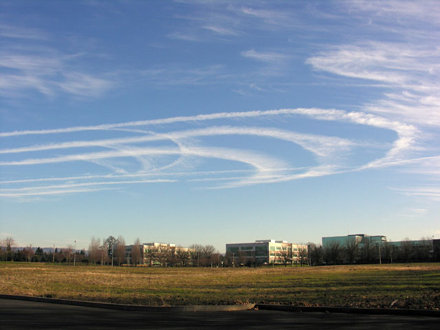
This photo was taken near Portland, Oregon on December 11th, 2005, at around 11AM.
So why would a plane be flying in this unusual pattern? Well, it turns out it’s not really very unusual. It’s called a “holding pattern“, and it’s a very specific pattern that planes fly in when they need to hold their position. Holding patterns have this very distinctive shape because the aircraft have to fly them in a very particular way that takes exactly four minutes to complete, so the ATC can know where they are, and when they will be facing in a particular direction. They fly straight for a minute, then turn 180 degrees over a minute, and then fly straight again. It looks like this:
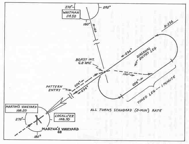
For passenger jets, holding patterns are most common on the approach to busy airports (the one above is for Martha’s Vineyard), and it’s not too uncommon to make a few turns in a holding pattern shortly before landing. The contrails in the above photo is probably not this, as it’s at too high an altitude. Passenger jets do sometimes enter high altitude holdings (I’ve been in one once as a passenger), which could account for this.
 High altitude holds are also used by refueling tankers, as they wait for the planes they are going to refuel. Pilots obviously also have to train to fly in high altitude holds, and given the number of turns above, that’s the most likely explanation for this particular photo.
Remember the winds at altitude are typical around 50-100mph, so after the four minutes loop, the previous contrail could be blown around five miles away, giving the illusion that the plane is now holding over a different area. It’s not. The plane is playing over the same area, but the contrails have moved.
Of course, if you don’t know this, it might look a bit odd to you. Some people work these racetrack contrails into the “chemtrails” conspiracy theory. Look at this poster on the right. There’s a photo of a racetrack contrail with five turns, separated and distorted by the wind. Overlaid is the text “Look up, Phone Radio DJs”.
These racetrack contrails are pretty rare (unless you live near a training area), but hopefully now if you see one, you’ll be able to tell what is going on, and not feel the urge to call a DJ.
[BTW, the plane in the upper right of the poster is a Boeing E-6 Tacamo, dumping fuel]
[Update Oct 2011] This video shows one situation that can lead to racetrack contrails. If an airport, even hundred of miles away, is experiencing delays, then the incoming traffic might get put into a holding pattern.

I thought contrails could only form at high altitudes, where a large temperature difference exists between the engines and the air. Is this article saying that contrails can be formed at lower altitudes too, like when a plane is about to land? Why is this an exception? Why then are planes not always creating contrails at vast ranges of altitudes and temperatures?
Contrail formation does not require high altitudes, contrail formation requires low temperatures.
Generally the only time the temperature is low enough (40 degrees below freezing), is at these high altitudes, usually above 26,000 feet.
Contrails can form at ground level, if it is cold enough. In Alaska you get “ice fog” at ground level, which is the same kind of condensation into ice clouds as happens with contrails. See:
http://www.gi.alaska.edu/ScienceForum/ASF13/1319.html
This article (Racetrack Contrails), does not suggest that the racetrack contrails are at low altitudes.
I’ve held at 37,000 feet commonly going into JFK some 200 miles south of New York. It’ not uncommon to turn back to the south and see your contrail. Happens all the time.
Ryan
jetBlue pilot
How long are contrails supposed to linger in the air??
in the photo above there is whispy clouds around the racetrack circles, if its water vapour how long does it take to dissolve into the atmosphere?
Bill, contrails basically ARE clouds – so they last as long as nearby clouds do. (usually a bit longer, as they are very dense).
I talked a bit about this here:
https://contrailscience.com/how-long-do-contrails-last/
There are, at this time, 9:44 EST 8 planes flying in circles in the vacinity of Clarion, PA… funny to watch… and nowhere near an airport so someone out there could probably snag one of those u-turn vids you want ;-p Unless the FlightAware site is off they’re not flying a ‘racetrack’ pattern.
awe… 9:54 and there’s only 2 left ;-( They were all going to LGA which I think is New York Laguadia? But one was from PIT and one from CLE so why not hold them on the ground instead of burning 20 mins of fuel circling? Or were they doing something more sinister 300 miles from their destination? ;-p
Probably just a separation thing. Planes have to arrive in their destination in a specific order. Doing a 360 (a circle) is something that ATC tells you to do – it’s not a racetrack hold, as those are at specific points, it’s just a way of moving you back 2 minutes (after a 360, which takes 2 minutes, you end up in the exact same point (well, except for wind, close enough), and it’s a lot easier to do that a racetrack).
I can understand that, but they raise ticket prices partially based on fuel prices rising… So leaving from PIT or CLE and circling for 20 minutes 5 mins NE of PIT is wasteful… I guess it can be blamed on the immense amount of air traffic and limited number of runways that can support large passenger jets? That 24 hour loop of nation wide air traffic is still crazy to watch after 20 times… there’s a few hundred, maybe a thousand planes at one point and it’s pretty dark… 5AM or so and the next few hours you can watch the outline of the USA form, particularly the eastern coast, and fill in the central parts to a lesser degree
Yeah, the airlines certainly don’t want to be put in holding patterns – very expensive. But it’s not their call – it depends on the traffic.
I have just seen 3 above london…hmm. Looks more like 3 6s you know, 666, the mark of the devil…I have no clue why abouve london, and pray its nothing bad
Hi Uncinus,
Did you see the racetrack contrails yesterday over Los angeles, Ca. ? They looked very much like the picture at the top of this page taken near Portland, Or. I saw them from approx. the same angle as I saw the VooDoo1 tracks on 11/20/08. The trails I saw yesterday were even more impressive than the 11/20/08 circles. I’m wondering if this was a repeat of the VooDoo1 avionics tester. Robust contrails today as well which correlate with the water vapor maps as we get ready for an approaching low.
-Bryan
I did see some parallel contrails in the morning, they did not last long though. I thought they were just regular flights though.
It was not Voodoo1, it was not flying yesterday.
http://flightaware.com/live/flight/VOODOO1
Chemtrails
A quote from the unintended consequences of sulphate aerosols by Massachusetts Institute of Technology Department of Civil and Environmental Engineering
“Of all these options, the most practical one to use is airplanes. The reason is that technology capable of flying into the lower stratosphere in both the tropics and the Arctic already exists. In fact, larger planes with a larger payload can be used in the Arctic due to a lower stratospheric altitude in that region. Robock et al. (2009) suggests planes such as the KC-135 Stratotanker or the KC-10 Extender, both of which have a large payload and can be operated continuously. A large fleet of these craft would be available at a minimal additional cost because they are currently used in the military”.
http://ocw.mit.edu/courses/civil-and-environmental-engineering/1-018j-ecology-i-the-earth-system-fall-2009/projects/MIT1_018JF09_sw_paper4.pdf
A quote from the unintended consequences of sulphate aerosols by Massachusetts Institute of Technology Department of Civil and Environmental Engineering
“Another aspect of the experiment that needs to be considered is the method of sulfur dispersal. Budyko (1977) originally suggested adding sulfur to plane fuel. This method, however, would require that the fuel used in the stratosphere be separated from the fuel used below the tropopause in order to minimize pollution of the troposphere (Robock et al., 2009). A more practical option is to attach a nozzle to the plane running from a separate tank. In fact, both of the suggested aircraft already have a nozzle, as shown in Figure 4, because of their use as mid-flight refuelers, so no additional alterations would be required”.
http://ocw.mit.edu/courses/civil-and-environmental-engineering/1-018j-ecology-i-the-earth-system-fall-2009/projects/MIT1_018JF09_sw_paper4.pdf
Acid despositions from sulphate aerosols
http://climate.envsci.rutgers.edu/pdf/aciddeposition7.pdf
From Wikipedia.
And finally, just a little speculation about military jet fuel… NASA have openly said in public, that they want to own the weather by 2025. Funnily enough, chemtrail reports started about the same time the military switched to JP8 Jet Fuel. JP8’s additives are protected by patent. Could this fuel react with the compounds they are spraying?
“JP-8, or JP8 (for “Jet Propellant 8″) is a jet fuel, specified in 1990 by the U.S. government. It is kerosene-based. It is a replacement for the JP-4 fuel; the U.S. Air Force replaced JP-4 with JP-8 completely by the fall of 1996, to use a less flammable, less hazardous fuel for better safety and combat survivability. The U.S. Navy uses a similar formula, JP-5. JP-8 is projected to remain in use at least until 2025. It was first introduced at NATO bases in 1978. Its NATO code is F-34. It is specified by MIL-DTL-83133 and British Defence Standard 91-87”.
http://en.wikipedia.org/wiki/JP8
Owning the Weather
“In 2025, US aerospace forces can “own the weather” by capitalizing on emerging technologies and focusing development of those technologies to war-fighting applications. Such a capability offers the warfighter tools to shape the battlespace in ways never before possible. It provides opportunities to impact operations across the full spectrum of conflict and is pertinent to all possible futures. The purpose of this paper is to outline a strategy for the use of a future weather-modification system to achieve military objectives rather than to provide a detailed technical road map”.
http://csat.au.af.mil/2025/volume3/vol3ch15.pdf
From Rense.com
“This has been a commonplace in the United States, and apparently, numerous other countries, as well, for about six years now! Those who examine these phenomena have termed them “chemtrails”, to distinguish them from contrails, and to emphasize the evident presence of foreign substances in the clouds. Since about 1997, these tracks have been a constant presence in the skies of the country”.
Unmarked aerosol aircraft on military bases.
From inside the RAF
FROM MAY 2010 – PLEASE READ ALL THE NOTE
John Smith
Alright mate how’s you these days? Am living near a town now in the RAF, quality like. What’s the entire chemtrail thing about like?
Martin Wac Hand
Mate, it’s sick, you should see my sky 🙁 See if you can get any info, or a piss pot of kerosene for me so I can get it tested.
John Smith
What kind of info you want? Yeah man a can get u aircraft juice if you want sum like.
Martin Wac Hand
Like if you see any unusual attachments being installed or anything, their really fucking up the sky man, just uploading a video, that many chemicals it’s making a rainbow and big black shadows where the lines are being laid, it’s relentless here, none stop at the moment. Whatever it is, it’s intensified since the ash cloud and all the planes were grounded
John Smith
Well a can tell you this much mate, I work on censored, my squadron sends up ten jets 5 times a day, each jet with each flight burns 6 tones of fuel, an there’s 6 squadrons on my base, a big jet say flying to America will burn around 100000 kg of fuel. Lot shit that like! Ash cloud don’t affect us like, engine are made different.
Martin Wac Hand
I know, NATO held unprecedented exercises during the last Ash cloud in April and I think I photographed UAV
John Smith
What is it that you think is going on with the clouds? Don’t understand but want to.
Martin Wac Hand
They are either attaching aerosols to aircraft, or mixing microscopic particles with jet fuel, which create chemical clouds. You heard of HAARP or Scalar weapons?
John Smith
Mate the clouds are made by the rapid heating then cooling of the air going threw the combustion chamber of the engine, definitely no aerosols on the jets I have seen, and there is no switch I don’t know, and there isn’t any that would enable the jets to do anything of that sort. Plus that rules it out of being in the fuel because without any device to select the chemicals there would b a thick cloud or a mist as the jet taxi past and away from me an a can guarantee that doesn’t happen. Honestly mate if that’s what you think is happening it doesn’t happen with military aircraft and civil aircraft wouldn’t be doing it iv we didn’t, were a lot more secretive than them and we control weapons in the air in and around Britain, just being honest with you not telling you your wrong but the idea of that happening isn’t something I personally had an aircraft engineer in the RAF have ever seen or heard of. I’ll get you some fuel for two weeks time when am back in town to help prove this to you mate.
Martin Wac Hand
There have been unmarked aircraft too, you should see it here today. Something is wrong.
John Smith
Mate there installing new attachments on the big unmarked jets on are base today, maybe you were right, we’re not allowed anywhere near though, never would have fort unless a spoke to you.
Martin Wac Hand
Just be careful, no doubt I’ll be getting watched. Friend from Israel says they are wing attachments.
John Smith
There not here mate definitely on the bottom rear of the fuselage, they won’t suspect me mate. Keep you informed
Martin Wac Hand
Laughing, everyone’s a suspect when freedom is in danger…
From chat:
John Smith
Flying the fuck out of it tomorrow mate, b aware!
Me
Loads yeah, Any rumours? What’s the lads saying?
John Smith
We’re doing waves tomorrow, big jets doing , they usually do . No rumours mate, lads are looking up more like, and looking into it, might have started a revolution on my squadren
Me
Good. They need to know really
Me
Soon they’ll tell the public that it’s for their own benefit
John Smith
Definitely mate, weird thing is unless you get it pointed out to you, you never notice.
Like most people do LOL
but we are waking up fast
I have hardly seen any all weekend.
John Smith
I just look into it, I know you’re not a knob so a researched a little bit n found it’s a big thing that’s covered up a lot to the press. People are waking up to it
Me
Yeah boy, it makes me happy to hear that 🙂
John Smith
Don’t know, I am near a town and there isn’t a thing in the sky, sound mate
Me
Same here and it’s been over 25 degrees here
John Smith
That’s how it’s suppose to be like. People can’t say I am crazy here; crazy man couldn’t do my job 4 real.
You know that MIT undergraduate student’s paper (which is a sample term paper for Ecology I) is basically about reasons why we should NOT attempt geoengineering with Sulphate Aerosols (the “unintended consequences”), and quite clearly states that nobody has done it.
It’s interesting how people try to use papers like this – some kid at MIT writes a term paper, and suddenly that’s evidence – some scientists write something called “Owning the weather by 2025”, and suddenly that’s official military policy (despite the paper itself saying quite clearly that this is NOT military policy).
Sounds like “John Smith” makes some good points there – particularly about how if there was something in the fuel, then it would totally contaminate the base with all the takeoffs.
Your game is up, people are clocking on to geoengineering and the fact that it all boils down to population reduction.
But why would you use such a obviously visible method (aerosol ops) to control the population. Why wouldn’t you do it through much less up front methods. Food, water manipulation, secret hormone infusion, a methodical system that discourages procreation. Come to think of it- why would the US simultaneously hand out child tax credits and then spray down the masses (at a huge expense) to lower birth rates?
Finnally, if this program is used for biological methods as you claim, what type of air filtration method are you using? Do you worry how those chemicals affect you? Do you grow your own food indoors? Do you boil your own water? Wear a face mask? Do you openly encourage others to protect themselves?
I see many who claim this is happening but no one seems alarmed enough to do anything about it besides rant online.
Aluminium chloride in antipersperant spray is much more dangerous than anything spread around at 30,000+ feet…….
While browsing MODIS satellite images of our neighborhood from April 2010, I spotted an unusual contrail pattern. It is dated April 12th, a few days before the Eyjafjallajökull eruption.
[img]https://contrailscience.com/wp-content/uploads/AERONET_Cabauw.2010102.terra.crop.jpg[/img]
cropped from: http://rapidfire.sci.gsfc.nasa.gov/subsets/?subset=AERONET_Cabauw.2010102.terra.250m
At first glance, it looks like another example of AWACS coils. However, a closer look showed that it is one half of a diagonally cut racetrack contrail, with each contiguous segment comprising a leg and an arc. Presumably, the other half of “racetrack” happened to be in a ‘drier’ area and hence left no persistent contrail.
This is not a typical holding pattern: it is too far from the holding areas of the nearest airport (Schiphol), and it seems too big. One leg and one arc together measure 70+ km, so one complete round is about 150 km long. it would take at least 10 minutes to complete one round at a cruise speed of 900km/h. The contrail was blown away by north-eastern wind with estimated speed about 75 km/h at the estimated contrail height of 9+ km. In less than two hours the remains of the contrail pattern reached the British shores: http://rapidfire.sci.gsfc.nasa.gov/subsets/?subset=AERONET_Cabauw.2010102.aqua.250m
The plane made more than four complete rounds of this pattern, flying it for more than 40 minutes, possibly even longer.
Is this something unusual or not? Were there any reports of aviation incidents in this area at the time (about 11:05 UTC) and date (04/12/10)?
A 40 minute hold would be rare, but not unheard of.
I don’t know where you could get detailed infor on what was happening at that time/space other than by asking the air traffic control organisation responsible for the airspace, but I suspect they might not keep tapes this long.
Possibly just some kind of test flight. Like:
https://contrailscience.com/voodoo-contrails-over-los-angeles/
The only problem with your estimate of size is that turn rates are pretty set in stone. Either it’s a two minute turn (therefore making one 180 degree reversal equaling a one minute turn.) or it’s a half bank turn making one turn segment two minutes long. It’s exrtrmely uncommon to turn shallower than that. The most common way to make holding patterns larger is to extend the leg distances or times.
The other problem I have is the trails are still pretty solid even in the “oldest” trail segment which means, to me, the trails are not that old.
Thirdly, remember, planes can literally hold anywhere with todays current technology. I believe there is some rule stating that ATC has to hold planes based on some fix or radial but that could still be virtually anywhere.
AWACS do also seem to fly in racetrack patterns, according to a quick google:
http://www.google.com/search?sourceid=chrome&ie=UTF-8&q=awacs+racetrack
Thank all who reply.
I did all geometrical measurements with the Google Earth tool. For example, the “oldest” trail segment is up to 2.5 km wide that seems OK for a 45 minute-old persistent contrail.
There is an independent estimate of time. In the aqua image taken at 12:55 UTC, there are still discernible two crossing arcs, the location of which is shown with white lines at the screenshot below.
[img]https://contrailscience.com/wp-content/uploads/Picture 6.png[/img]
Their crosspoint is perfectly alined with the four arc crossings in the terra image (11:05 UTC) and is 137 km away from the furthest and “youngest” of them. Assuming that it was the latter that was still discernible about 1 hour 50 minutes later, the wind speed was about 75 km/h. The four arc crossings are evenly separated with the distances between the adjacent crosspoints about 13 km. From this, the time to complete one round was again about 10 minutes.
I think that a military (e.g., AWACS) or test flight is the most likely explanation. There were no other contrails in this area but one about seventy miles south-west from the “racetrack”. I just wanted to rule out the possibility of a troubled commercial jet burning excess fuel over an isolated spot in the North Sea before landing.
Please list your assumptions. You would need wind speed at altitude certainly but are you factoring in aircraft speed as well? That may be hard to determine. I don’t remember max holding speeds in Europe but regardless, the most efficient holding speeds are always less than max when you are at altitudes where contrails would form.
I guess I just don’t see how one leg and one turn can equal 70 km. Could you screen shot a measurment tool or something? To me the newest trail looks like about 5 km in the leg and 7 or 8 in the turn.
My main assumption is that the trail grid is made by a single plane flying the same “racetrack” pattern several times with wind blowing the trail away in a constant direction at a constant speed. The rest is measured and calculated from the images and metadata. Here is the screenshort of my measurement of the second newest trail with the tool window overlayed:
[img]https://contrailscience.com/wp-content/uploads/Picture 8.png[/img]
The blue line gives the direction of wind. A the other end of it is the position of the assumed crosspoint of the two newest trails in 1 hour and 50 minutes. The wind speed, 75 km/h is calculated as its length (137 km) divided by the above time. The intervals between crosspoints of sequential trails are measured to be about 13 km; dividing this distance by the calculated wind speed gives the time of one round about 10 minutes. This estimate is independent on the plane speed and the length of “racetrack”.
I can only say that the length of “racetrack” is at least twice the length of the visible trail segment, possibly longer. I’ve just rounded it up to 150 km and divided by the plane cruise speed of 900 km/h to get the same 10 minutes. The speed could of course be less than that, but the “racetrack” can also be longer than my estimate.
PS I have measured the contrail height (9+ km) by the method described in my comments to https://contrailscience.com/measuring-the-height-of-contrails/, in particular comment 19.
Or, that could be someone spraying something for some unknown reason. Even if it is, it still doesn’t show how every youtube video with the name “chemtrail” in the title is that of a “chemtrail”.
People will be spraying things into the sky from time to time. Of course they do.
But, to insist that a trail contains chemicals, just from what we see from the ground, is and will always be a stupid assumption.
BTW…could that be an emergency fuel dump?
TheFactsMatter said:
“Or, that could be someone spraying something for some unknown reason.”
Isn’t this obvious? This strange Iceland-focused grid was a part of the successful NWO plot to shut down the European airtrafic in order to assess the results of their spraying operation :))
Uhm, will the wind not make the turn radius of the trail bigger compared to the actual track if we assume the direction is counter-clockwise and the plane tries to stay in the pattern above ground ?
The full track would look probably look like that (in exaggeration):
[img]https://contrailscience.com/wp-content/uploads/racetrack.gif[/img]
How about aerodynamic contrails from a glider?
“will the wind not make the turn radius of the trail bigger?..”
Actually, it does in the above case. The arcs are not perfect semicircles but approximately elliptical with the ratios of long-to-short axes being about 1.2-1.3. The estimated radius of actual racetrack is about 10 km. This would shorten the length of racetrack a bit, but not significantly.
JFDee said:
“The full track would look probably look like that (in exaggeration)”
Realistically, for the probable racetrack pattern (red), the full trail would probably look like that:
[img]https://contrailscience.com/wp-content/uploads/Picture 9.png[/img]
The visible contrail segments are highlighted with white lines, the would-be contrail segments are drawn in yellow.
Well then, with all of that I must admit that I can’t imagine how or why the turn rate would be soooooo slow but your evidence shows true and I must believe you.
I take that back….
There’s just something wrong about that math. I would say that it’s far fetched to believe that the aircraft making the trail has some sort of autopilot that is capable of flying less than half standard rate turns. So at the very most these turns are half rate which would equals one 180 turn equaling two minutes. Assuming a ground speed of 460 mph (740 Km) the turn would be two minutes making a distance travelled in the turn 15.33 miles or 24 km.
So how much error is in that measuring tool?
You could hand fly a turn at altitude and make whatever turn rate you wanted but it would be impossible to get the kind of consistency shown in the pic. The only other way to get a large arc is to do a DME arc from a VOR but that’s not at all what’s going on there.
So I don’t know why this one slide deserves this much debate but I don’t think we’ve come to the right conclusions.
“how much error is in that measuring tool?”
Google Earth approximates the Earth surface with a geoid on which the satellite photos are mapped. The best available resolution of MODIS photographs is 250 m per pixel.
“it’s far fetched to believe that the aircraft making the trail has some sort of autopilot that is capable of flying less than half standard rate turns.”
I read that AWACS had flown 10 complete circles of 40 km diameter above North Sea, its coiled contrail that was recorded by a number of satellites on that date (see the links in my comment: https://contrailscience.com/persisting-and-spreading-contrails/#comment-55220). I do not see why it could not fly a big racetrack of about the same length.
CORRECTION to my post 39:
Because of wind, the opposite legs of a racetrack contrail won’t be parallel and the full trail would probably look like that:
[img]https://contrailscience.com/wp-content/uploads/Picture 10.png[/img]
The total length of red “racetrack” in this drawing is 130 km.
Learning something new today (Processing), so used this as an exercise:
https://contrailscience.com/apps/racetrack_contrail_simulator/applet/
(Does not work well in Chrome for some reason, try Firefox)
Question: Is a racetrack hold always ground-relative a perfect lozenge shape? Are the sides parallel? The same length? (Meaning the actual track, not the contrail)
I’m impressed. Are you planning to add a few control handles?
The answer to your question is probably no, but it is a good first approximation, as the constant wind speed and direction.
This is exactly what I imagined would help with clarification.
Awesome, and runs fine in Opera!
Looks like there is some game coding experience involved 🙂
Uncinus- I think you’re asking if holds are always designed to be “lozenge” shaped? If so yes and no. FLying a racetrack pattern is not really the goal of a hold. The goal is to stay within a protected area of airspace predicated by a fix and a radial/distance inbound to that fix. Consequently, in a no wind condition the hold will look like a perfect racetrack with parrallel lines and equal radius turns. But no one cares what the racetrack “looks” like either in regards to ground track or otherwise. All that matters is the inbound section of the hold be on the radial and have the right distance. Consequently, the outbound portion of the hold will have all sorts of corrections in it to ensure that the inbound portion works out right. I imagine if you don’t have your instrument rating you haven’t been shown holds but it’s a full ground school lesson and you’d have to go practice them for a few hours to get all the nuances down.
The problem I have with this picture is that 99.99% of aircraft that are out there doing holds have no way to make a really “big” hold. The only thing you can change is the leg length. I won’t go into it but I suppose the turn that we are able to see in the pics could be elongated due to the effects of the wind.
As far as your racetrack generator- it looks ok but it appears your turns have not been effected by the wind at all. Both should have a different radii due to the wind pushing on the plane and changing it’s gorundspeed. I’m sure thats very difficult to reproduce because the wind effect changes with every degree change in heading during the turn.
Captfitch,
I take your arguments that this unlikely was a commercial plane flying a “racetrack” on autopilot. These do not rule out a military or test flight, do they?
People practice things all the time. I remember my touch and go’s. This could be one of any number of things. The question is, is it “normal” for people to jump to conclusions about what we see in these images.
I think that is “normal” in the sense that that’s what most people do. Rather than leave something unexplained, the human mind prefers to either ignore it, or to shoehorn it into an explanation.
That also applies when an explanation is too complicated. Take the “dark line” in front of some contrails when lined up with the sun. The actual explanation is somewhat head-hurting in it’s non-intuitiveness (a thin shadow volume the air), so some people dismiss that explanation, and go instead for some kind of negative laser guidance beam, or antimatter-chemtrail, or something else that seems simpler, but is actually way more complex.
I’ll tweak the simulation when I have time.
Let’s try embedding it. Does this work?
[Edit] No, crashes Chrome.
The embedding worked OK in Safari and Opera.
I think I’ll put up a dedicated page for simulations. The comments have enough stuff in them already.
Update, with controls
https://contrailscience.com/apps/racetrack_contrail_simulator/applet/
(Might need to empty your cache for it to refresh).
I’m going to make it to scale, and overlay over MODIS date.
“The question is, is it “normal” for people to jump to conclusions about what we see in these images.”
I do not think it is normal, but it is typical. A normal thing to do is to come up with a plausible hypothesis and to work it out step by step.
In this particular case, it was suggested that the observed contrail pattern was created by a single aircraft flying a “racetrack” pattern in the presence of wind. The “racetrack” only partly overlapped with an area where atmospheric conditions were right for persistent contrail formation. This hypothesis was shown to explain the observed contrail pattern well, whereas no as good as this or better alternative was suggested. It can be proven by the flight identification, but the direct information on this flight may be unavailable to public. Still, in the public domain, there may be information that could help to explore different possibilities of what kind of flight it was: military mission, training or test flight, incident-related action etc. and to estimate the likelihood of finding more similar patterns.
For example, from the NATO AWACS site (http://www.e3a.nato.int/home.htm), the operational altitude, 9,150m, and average speed of AWACS plane, 770 km/h, are in a good agreement with my estimates from the satellite photos. From another document ( http://vateud.org/index.php?option=com_content&view=article&id=117 ): “the AWACS pattern is defined by two center points. Around these two points a pattern is flown either as a racetrack pattern or a figure 8 pattern.” This also fits nicely, but it hangs on a single example of putative “racetrack”.
So far, all other examples of probable AWACS contrails that I found on satellite images were “coils” from a circular orbit. I think that my latest finding deserves its own post.
Recently I have stumbled on an eyewitness account of a plane flying in circles for more than three hours near a small island in the North Sea ( http://www.abovetopsecret.com/forum/thread442036/pg1 ). The eyewitness took pictures of resulted coiled contrails with his mobile phone.
[img]https://contrailscience.com/wp-content/uploads/06112008020_06802_11795019.jpg[/img]
I have checked MODIS images on that date (November 6th, 2008). The North Sea was completely covered by clouds except a small area near the Norway coast. In both Terra and Aqua images, there is a coiled contrail. Coincidentally, the satellites photographed this area at about the same time (12:05 UTC and 12:20 UTC), just within the time interval between the first and last eyewitness’s pictures.
[img]https://contrailscience.com/wp-content/uploads/Norway_terra_2008311121000_crop.jpg[/img]
from http://rapidfire.sci.gsfc.nasa.gov/realtime/single.php?2008311/crefl1_143.A2008311120500-2008311121000.250m.jpg
[img]https://contrailscience.com/wp-content/uploads/Norway_aqua_2008311122500_crop.jpg[/img]
from http://rapidfire.sci.gsfc.nasa.gov/realtime/single.php?2008311/crefl2_143.A2008311122000-2008311122500.250m.jpg
Note that these pictures have been cropped from the swaths of raw images. Unfortunately, this area of Earth surface is not included in any of the MODIS ready subsets, where images have been transformed, assembled and mapped on Google Earth, as it was on the satellite pictures that I showed previously. Still at least one bit of useful information can be readily extracted: in 15 minutes or so between the Terra and Aqua images, AWACS clocked up one more full turn.
Uncinus,
in the Update, with controls, the aircraft is flying clockwise, whereas before it was flying anticlockwise, in agreement with MODIS photo. Was it done deliberately? Perhaps, this calls for more handles.
I changed it to clockwise (right hand turns) as that’s standard for actual holds.
I’ve made a dedicated post for the simulator, with both embedded JS and a separate Java version:
https://contrailscience.com/contrail-simulations/
I’ll put in a toggle for the direction. It’s not there now mostly due to the lack of UI elements in Processing. I still need to:
– Add a photo background, setting the meters_per_pixel appropriately (Modis gives you this info)
– Have correct/editable leg lengths, currently they are fixed
– Adjustable hold position heading
Based on a pretty rough fitting in Google Earth, they seem to be around 45 km in diameter.
Better fit, made by setting the plane speed to 280, and the turn rate to ten minutes.
https://contrailscience.com/contrail-simulations/
Things can be tweaked many ways to get a pattern that matches.
The AWACS operation speed is 770km/h or 478 km/h, which gives us a turn diameter of about 24.5 km at six minutes
“I changed it to clockwise (right hand turns) as that’s standard for actual holds.”
So far, all “circular orbit” contrails that I saw on satellite images were “anticlockwise” (left hand turns). Could it be a characteristic feature of a military mission? Also, “anticlockwise” from the satellite POV is “clockwise” to ground observers.
After digging up more military-related documents, I have found that this putative racetrack pattern may well be a tanker aircraft refueling maneuver. Its pattern is always a left-hand racetrack orbit. Its geometrical parameters can vary but they are typically in the same range, as the estimated here above.
http://www.google.co.uk/search?q=tanker+aircraft+racetrack+orbit
That sounds pretty plausible.
I have found a few more examples of putative “racetrack” contrails on the MODIS satellite images of the UK.
The first one had been photographed on February 12th, 2009 with a 15 minute interval by both Terra (11:55 UTC):
[img]https://contrailscience.com/wp-content/uploads/LHR.2009043.terra.250m.jpg[/img]
cropped from http://rapidfire.sci.gsfc.nasa.gov/subsets/?subset=United_Kingdom_Ireland.2009043.terra.250m
and Aqua (12:10 UTC):
[img]https://contrailscience.com/wp-content/uploads/LHR.2009043.aqua.250m.jpg[/img]
cropped from http://rapidfire.sci.gsfc.nasa.gov/subsets/?subset=United_Kingdom_Ireland.2009043.aqua.250m
This is almost certainly a contrail from an airport holding pattern, more precisely, from the NE Arrival Stack for London Heathrow Airport at Lambourne (LAM), which is incidentally a left-hand turn:
[img]https://contrailscience.com/wp-content/uploads/stacks.gif[/img]
I have combined both images in Google Earth. Note that the contrail from Terra image (outlined in cyan) does not align precisely with the wind direction derived from the Aqua image. This is because both satellites had seen the contrail at an angle but from the opposite sides, therefore on the Terra image it is slightly to the east from its actual position, whereas on the Aqua image it is slightly to the west. An approximate “full” contrail pattern (insert) was generated with the contrail simulator (https://contrailscience.com/contrail-simulations/).
[img]https://contrailscience.com/wp-content/uploads/LHR_stack_Lambourne.jpg[/img]
In 15 minutes minutes the contrail drifted south by 25 km, that gives the estimated wind speed of 100km/h. From the distance between the points of contrail self-crossings, 17 km, one full turn has taken about 10 minutes. I think that the time interval between the two images was a bit shorter, about 12 minutes, so wind probably was stronger, about 125 km/h (78 mph) , whereas one full turn was quicker, about 8 minutes.
Two more examples of putative “racetrack” contrails are found together with the contrails from the AWACS-type circular orbits. One was photographed on the same day, March 20th, 2009, with the publicized long coil-shaped contrail over the North Sea (http://news.bbc.co.uk/1/hi/sci/tech/8309629.stm). Its remnants can be seen on the right hand (eastern) side of the following image, whereas the partial racetrack pattern can be seen inland on the left hand (western) side:
[img]https://contrailscience.com/wp-content/uploads/UK_contrails.2009079.aqua.crop.jpg[/img]
cropped from http://rapidfire.sci.gsfc.nasa.gov/subsets/?subset=United_Kingdom_Ireland.2009079.aqua.250m
The other example was recorded nearly a year later, on March 5th, 2010, a hundred miles to the south from the above example. The partial racetrack pattern is in the upper left part of the image:
[img]https://contrailscience.com/wp-content/uploads/coil&racetrack_2010064.aqua.crop.jpg[/img]
cropped from http://rapidfire.sci.gsfc.nasa.gov/subsets/?subset=United_Kingdom_Ireland.2010064.aqua.250m
It is rather faint on the background of thin cloud layer. To the left of it, in the same layer, there can be seen faint coils of contrail typical for the AWACS-type circular orbit. These coils actually drifted above my home town, but I spent that day inside and did not notice them. However, on the web I have found a few pictures of this contrail taken by a person who did. It gave me an opportunity to try some things that I have learned from this site, in particular, to do my own analysis similar to https://contrailscience.com/contrails-above-and-below/ . I’ll continue my comment there, when it’s ready.
Excellent work.
It strikes me that it would be possible to automatically detect “interesting” racetrack contrails in satellite images. There’s already work done to detect linear contrails. This paper is pretty cool
http://ams.confex.com/ams/pdfpapers/171549.pdf
I also have found a useful resource for the interpretation of “interesting” contrail patterns around here.
http://www.aeroresource.co.uk/aviationmaps/
I spent over 20 years as an Air Traffic Controller. Most of that time was spent controlling aircraft in holding patterns. Standard holding pattern was a 2 minute leg, left or right hand pattern, standard rate turns, 8 or 9 or more in the stack at any one time not unusual. The legs were often shortened, or extended, depending on the sequencing reqired by the Flow Controller. Radio Navigation Charts show the usual holding points, but a pattern can be set up anywhere the controller wants it. Holding patters where I worked, were anything from 3500ft, up to 28,000ft, high, depending on the situation.
I suggest anyone with an interest in this subject consults some textbooks, educates themselves, and speaks to working Pilots, Airline, Private, Military. There is no big Chemtrail mystery. Study books, not some youtube rubbish.
Upper winds can be very, very strong. The contrail you see may have come from many miles away
JB, thank you for the info.
I think your arguments are generally accepted here, at least by the proponents of this site. I just try to quantify them from satellite data. However, apart from the airport stacks, there are other racetrack and circular orbits, usually attributed to military aircrafts. Here is a recent Terra image of an area of the North Sea near the British coast:
[img]https://contrailscience.com/wp-content/uploads/North_Sea_2011021.terra.250m.jpg[/img]
cropped from http://rapidfire.sci.gsfc.nasa.gov/subsets/?subset=AERONET_Cabauw.2011021.terra.250m
There are contrails from a circular orbit of 15 km diameter and a racetrack with about 50 km long legs, separated by about 8.5 km, highlighted below in magenta and green, respectively
[img]https://contrailscience.com/wp-content/uploads/North_Sea_2011021.jpg[/img]
It looks like a textbook air-to-air refueling pattern:
[img]https://contrailscience.com/wp-content/uploads/ARAP.gif[/img]
Sorry , misprint to my earlier, typing too quickly, obviously 28,000ft! not 280,000ft
Fixed it for you. I was going to ask what type of plane that was 🙂
I just came across an article about a sky-born telescope platform that is about to start a regular service this year. It’s a reflector system for the infrared spectrum on-board a Boeing 747 SP.
The project features a cooperation between NASA and the German counterpart DLR; the name is SOFIA (Stratospheric Observatory for Infrared Astronomy).
The interesting side regarding contrails is that the plane will operate at it’s ‘usual’ height but will follow patterns optimized for observation of specific astronomical targets.
The German web site (contractor of the DLR) has screenshots of the software tools offered to researchers worldwide to aid them with applicating for observation time. There is an example of how a mission flight path might look like – this will certainly make for some very interesting contrail patterns …
[img]https://contrailscience.com/wp-content/uploads/flugplaner03.jpg[/img]
English web site:
http://www.sofia.usra.edu/
A flight planning tool in Java – enter target object and get visibility window:
https://dcs.sofia.usra.edu/observationPlanning/visibilityTool.jsp
Software screenshots, including the one above:
http://www.dsi.uni-stuttgart.de/observatorium/beobachtungen/flugplaner.html
Here is another couple of spiral contrail patterns from the Earth Snapshot site:
http://www.eosnap.com/?s=spiral+condensation+trail
[img]https://contrailscience.com/wp-content/uploads/20090817-clouds-full.jpg[/img]
[img]https://contrailscience.com/wp-content/uploads/20090115-spiral-full.jpg[/img]
Both trails can be found at MODIS Satellite Data and measured with Google Earth tools:
http://rapidfire.sci.gsfc.nasa.gov/realtime/single.php?2009229/crefl1_143.A2009229105000-2009229105459.250m.jpg
http://rapidfire.sci.gsfc.nasa.gov/realtime/single.php?2009229/crefl2_143.A2009229111000-2009229111500.1km.jpg
and
http://rapidfire.sci.gsfc.nasa.gov/subsets/?subset=NAfrica_1_06.2009015.terra.250m
Eosnap gives standard explanation of both trails: “This was probably caused by an airplane not being able to land immediately and having to remain in a holding pattern…”
The patterns are very different and are distinct from the AWACS patterns above. That of Norway coast is from a right turn circular orbit about 70 km in diameter. The plane made at least four full turns, 20 minutes per turn.
The other pattern of Egyptian coast is from a racetrack orbit of about 40 km in long axis and about 20 km between the legs. Having made at least four turns, the plane went north across its contrail, away from the land.
someone is trying to take you in a circle. this is for one in a thousand ..tell your friends something is going on…!
Where in Scotland was Roger?
I asked myself this odd question having noticed that the pictures of two circular contrails from the web were actually the pictures of the same contrail, taken from two different locations in Scotland.
[img]https://contrailscience.com/wp-content/uploads/WiSWR.jpg[/img]
The first picture, taken by the scottish photographer Jim Bain on November 17th, 2007, is supplied with the info on geographic coordinates and viewing direction (http://www.geograph.org.uk/photo/613385). From EXIF data of a similar picture in Jim’s album on Flickr (http://www.flickr.com/photos/duartmore/3905432623/in/set-72157621863502383/), the pictures have been taken at around 15:07 GMT on that date. The Jim’s location and viewing direction can be independently verified with the help of Google StreetView that now includes the British countryside. The car park in his photograph and ground features around it can be seen from A914 road nearby.
The second picture, from Cathy Palmer’s blog (http://enjoyingthejourney.blogspot.com/2009/03/chemtrail-photos-from-scotland.html), is one of the two pictures of a circular contrail sent to the blogger by one Roger from Scotland. Their originals with EXIF data are available from Picasa album (http://picasaweb.google.com/lh/photo/JVvvsELWZnVtj8ACXuEZYw and http://picasaweb.google.com/lh/photo/TPaDF5F1l0HWqiNDlFf59g); they have also been taken on the same date, November 17th, 2007, at around 14:48 GMT.
In both sets of pictures, the contrail crosses itself at three points, A, B and C. This triangular grid allows to identify the equivalent points in the contrail images and compare variations of local width and density. These are remarkably similar in every point, for one example, the bulge in point D. All this means that it is indeed the same contrail. It also means that the clock in one or both cameras probably wasn’t accurate, and the time difference between the two picture is probably no more than ten minutes. In 20 minutes, the AWACS plane would complete one more full turn, so it would be another self-crossing in the later contrail, between points B and D.
In his descriptions of the contrail, Jim Bain is confident it was AWACS. From the pictures, it was indeed a left-turn circular orbit, but its other parameters – diameter and altitude – are unknown. No MODIS satellite images is currently available for that date, but there is another way to prove that it was a typical AWACS orbit – to find the Roger’s location at the time.
I have simulated an approximate template as in https://contrailscience.com/contrail-simulations/, placed it into Google Earth, scaled it to the orbit diameter of 40 km and oriented according to the Jim Bain’s viewing direction. Then I have raised a model contrail to the AWACS working altitude of 9.1 km and looked at it from the Jim’s viewpoint. After a few iterations I have achieved a reasonably good fit with both Jim’s pictures.
[img]https://contrailscience.com/wp-content/uploads/Jim_photo_1_fit.jpg[/img]
In the next step, I have determined an approximate direction from the model contrail toward the possible Roger’s viewpoint and scanned ground along it, looking for specific features. Recovered from Roger’s photos, the ground features revealed a nondescript countryside landscape of Scottish lowlands. Still, they seemed sufficient to identify the place on Google StreetView.
[img]https://contrailscience.com/wp-content/uploads/A928_Roger_viewpoints.jpg[/img]
Both Roger’s viewpoints are seem from A928 road north of Leys of Cossans at a short distance from each other. Viewed from these points, the same model contrail gives a reasonable fit with both Roger’s photos. Barely noticeable, there is also one of the two linear contrails that are seen in the Jim’s pictures, the other is out of frame.
[img]https://contrailscience.com/wp-content/uploads/Roger_photo_1_fit.jpg[/img]
Therefore, it was a typical AWACS orbit, moreover, the plane circled within known AWACS operational area.
I’ve emailed Uncinus the Google Earth (KMZ) file to link from here, if somebody would like to have a closer look.
You can use the “Upload Files” to add arbitrary files, and they will show up as links.
[file]https://contrailscience.com/wp-content/uploads/WiSWR.kmz[/file]
That’s some impressive contrail fitting there.
Awesome – have you updated the query on ATS?? 🙂
MikeC,
what query? If you mean my comment above (#56), I have updated it in Contrails Above and Below:
https://contrailscience.com/contrails-above-and-below/#comment-57493
Or was your comment misplaced?
I thought this started as a reference to a thread on ATS….I must have misread something or am confusing 2 threads…sorry.
Case solved?
At last I have discovered the most likely origin of the 2 April 2010 contrail, the satellite image of which is posted above in my comment (#23) and is used as the contrail generator background in https://contrailscience.com/contrail-simulations/ .
It was left by a USAF KC-135 Stratotanker in the beginning of Frisian Flag 2010 international exercise in the Netherlands that a few days later was halted by the volcano ash.
“Flying from their home bases, …a KC-135R Stratotanker from the USAF 100th ARW at RAF Mildenhall, supported some of the missions.” (http://www.milavia.net/specials/frisian-flag-2010-leeuwarden/)
The air refueling racetrack was inside, on the outskirts of the exercise area; its logged coordinates (from http://home.telfort.nl/mysteryship/vuhflogs/vuhf2010.html) nearly perfectly coincide with the newest lap of the contrail:
“12APR10 0648z “QUID 68” Mildenhall 100ARW KC-135 exercise Frisian Flag 2010
128.350 wkg Dutch Mil, 268.600 / Dutch Mil tanker control, entering the AR track (5314N00358E / 5314N00429E)…”
In the picture below, the exercise area is shaded red, the West and East ends of the racetrack (bottom leg?) are marked with W and E:
[img]https://contrailscience.com/wp-content/uploads/Frisian Flag 2010.jpg[/img]
I’ve appended the KMZ file on FRISIAN FLAG 2010 found at http://home.tiscali.nl/mysteryship/exercises/pastexercises1.html with the MODIS image and the racetrack coordinates (W and E):
https://contrailscience.com/wp-content/uploads/FF2010.kmz
Sorry for typo in the previous comment, it should be the 12th April 2010 contrail.
On a final note, this contrail was not far from the Dutch coast. International airforce exercises usually attract a lot of planespotters, so I thought that there could be some ground pictures of it on the web. Indeed, I have found a photo that was taken not by a planespotter but by a local resident:
[img]https://contrailscience.com/wp-content/uploads/Cirkels_St_Annaparochie_12_4_10_waddenzee.jpg[/img]
EXIF data show that the picture was taken less than ten minutes after the Terra satellite image. It was taken from the vicinity of Sint Annaparochie town that is about at least 70 and up to 120 km (45 to 75 miles) away from the contrail. I checked this with Google Earth, the satellite image trace raised to 30,000ft (9.15 km) above the sea level produced a perfect fit with the photo:
[img]https://contrailscience.com/wp-content/uploads/KC-135 Racetrack Contrail.jpg[/img]
Here is updated KMZ file:
[file]https://contrailscience.com/wp-content/uploads/FF2010updated.kmz[/file]
This resident has also made a video from the same spot and put in on YouTube:
http://www.youtube.com/user/ellebel9
Both photo and video are available from this page on a Dutch website:
http://www.niburuarchief.nl/index.php?&page=showarticle&id=11169 ,
which also contains many pictures of “Cirkeltrails”, most of which were taken at the time of Frisian Flag 2010 exercise.
BTW, these seem to be pictures of trails left by the aerial dogfights. But are they real contrails? I read somewhere that smoke cartridges are used to highlight the action.
Spotted in today’s MODIS satellite images taken above the Mediterranean Sea east of Malta at approximately 12:05 UTC:
[img]https://contrailscience.com/wp-content/uploads/coil&racetrack.jpg[/img]
cropped from: http://rapidfire.sci.gsfc.nasa.gov/subsets/?subset=NAfrica_1_05.2011088.aqua.1km
The coiled contrail on the west side has a clear signature of the AWACS circular orbit – left turn, about 40 km in diameter and 9+ km above the sea level, calculated from the distance to its shadow and the sun altitude at the time and place. To the east, there are contrails, which probably have been produced by another patrol aircraft of a air-to-air refuelling tanker, flying a very large racetrack orbit.
Sorry, I meant: another patrol aircraft or an air-to-air refuelling tanker.
BTW, something happened to the last image in my post #82. It was OK before, but now it is split vertically and its parts transposed.
The issues have always been my problem as well. believe me I have alot of friends who believe all the theories! population control, to make population sick(flu,Resp problems,etc) they even believe they are getting sick when they see a large amount of contrails in the sky, and the whole weather controlling theory as well. always get the THEY are doing this. Who is they can never get a answer or get the Government answer. My problem with that is if true than they in theory are dumping that on themselves as well and all their relatives and friends. So unless there is a race of super humans and everyone they know that dont get sick or effected by this or better known as “THEY” maybe should find and bring them forward as the best evidence to prove conspiracy point! Also why would a country try or preform population control on their own country therefore weaken it in all aspects. You would think that be the opposite and they would be doing this over other countries more so enemies of the untied states! also if the whole climate control and doing so to control global warming. This would mean our government believes in global warmer. From everything i have read and most of the talk the action taking by our government mainly the republicans pretty much says they don’t believe global warming is actually even happening. So why put efforts into something they say isn’t happening!
Here is a pretty interesting race track contrail…but its a military plane so it must be a “chemtrail” 🙂
[img]https://contrailscience.com/wp-content/uploads/racetrack contrail.jpg[/img]
I got new evidence for probable causes of large racetrack contrails here in the UK similar to those seen in the above satellite images. Watching today our “local” air traffic at http://www.flightradar24.com, I’ve spotted one plane flying large racetrack-like rounds north of Cambridge:
[img]https://contrailscience.com/wp-content/uploads/Screen shot 2011-07-04 at 13.47.51.png[/img]
According to the info on aviation message boards, the aircraft in question, a luxury Airbus A318-112(CJ) Elite; 9H-AFT, is undergoing installation of additional fuel tanks at Marshall Aerospace that owns our local airport. Apparently, it has been a test flight during which the aircraft has climbed up to 41 000 ft at the end of the second round before descending and returning back to the airport.
Unfortunately, because of a lot of clouds in that part of the sky, I couldn’t visually follow the plane or its trail during the flight, but eventually I have spotted it just before landing:
[img]https://contrailscience.com/wp-content/uploads/P1050365.JPG[/img]
Is that a luxury jet in that it would be owned privately? Like by a billionaire?
No, it belongs to a company that does VIP charters for about 11 000$ per hour (per person?).
You can check this on their website: http://www.comluxaviation.com/.
There is a video of this particular type of aircraft: http://www.comluxaviation.com/en/168-comlux-a318-elite.html
11000 is total cost- not per person cost. pretty reasonable for that aircraft really
Plus, you get a little more leg room than with, say, Air Namibia (according to the video) …
Interesting. I’ve lived by the Ottawa Macdonald-Cartier International Airport my whole life. My son and I spend our weekends sitting out at the east end of a runway watching planes come and go for years. Ottawa can become very cold in the winter. Unless they were spraying, contrails can only form when the temperture is cold enough, and the humidity is high enough. I’ve never seen trails like the ones you posted, ever. So logic dictates that either these aircraft are spraying something in the atmosphere or those trails were formed at 30-40 thousand feet. Too high for a holding pattern. I’ve got a photo that I took on an extremely warm day this past summer, heavy rain with clouds hanging at 2000 ft, and watched as a jet flew over the city under the clouds and laid down a chemtrail. Not possible for a contrail to form in these conditions.
Jeff,
You could have been seeing aerodynamic contrails, which are fairly common at low altitudes and even in tropical climates, and also during wet weather as you described. Generally, you won’t see many contrails from planes nearing airports as you describe. I’d enjoy looking at he photo you say you have.
Regarding your thirty years of not seeing contrails, there is no disputing that contrails exist and have done so since the 1920’s. Here is a photo gallery of persistent contrails through history:
http://metabunk.org/threads/487-Pre-1995-Persistent-Contrail-Archive
It is interesting to me that you just now noticed persistent contrails. The reason I say this is that many folks right there inOttawa were seeing them ten years ago as reported in the “Ottawa Citizen.” If others in the same city saw them ten years before you did, perhaps you just didn’t notice them as much as they did?
Twice in the past year I have held for several minutes in the mid 30s. Hundreds of miles from DFW.
my first comment is that people always say its just water in these trails, . . this is not true, actually the water would just be a marker making the area of the spent jet engine exhaust visible, . yes there is also pollution in these trails, . . and on a clear sky day, or on a satellite map photo. one can clearly see the extent of pollution being created over our heads thanks to this water vapor visibility, . .
L.A to Dallas= 22 hours by car times 150 cars= more pollution than 2.5 hours times one plane. Could be wrong. I think that’s been discussed here before as well as the effects of altitude.