Do contrails sometimes persist and spread out?
Yes, see the Encyclopædia Britannica article on vapour trails (contrails):
Contrail, streamer of cloud sometimes observed behind an airplane flying in clear, cold, humid air. It forms upon condensation of the water vapour produced by the combustion of fuel in the airplane engines. When the ambient relative humidity is high, the resulting ice-crystal plume may last for several hours. The trail may be distorted by the winds, and sometimes it spreads outwards to form a layer of cirrus cloud.
vapour trail. (2007). In Encyclopædia Britannica.Retrieved May 4, 2007,from Encyclopædia Britannica Online:
(The above quote is from the current EB. However, a Google books search dates the inclusion on the EB back to 1983)
Also see “A Field Guide to the Atmosphere“, by Schaefer and Day, 1981:
“Sometimes [contrails] are ephemeral and dissipate as quickly as they form; other times they persist and grow wide enough to cover a substantial portion of the sky with a sheet of cirrostratus“ (Page 137)
Are spreading contrails a relatively new thing?
No, it has been exactly the same for decades, the only change has been the size of jet engines (producing bigger contrails), engine technology (burning fuel more efficiently in high bypass jet engines creates cooler exhaust which is more likely to condense before it mixes with the surrounding air) and the amount of air traffic (producing more contrails). Spreading contrails have been mentioned consistently through the history of aviation, including in the popular press. Like Sports Illustrated , Nov 6th 1989:
Now, late in the afternoon, the hatchery explored and the fishing over for the day, Crooks points to the sky. Blue all day, it has now turned hazy. “Contrails,” he says. “The haze is caused by aircraft contrails that have gotten spread out till they cover the sky. This is a major air route from the East Coast to the West.”
For scientific discussion, see, for example, all these articles on contrails. In particular the one from 1970 titled “Airborne Observations of Contrail Effects on the Thermal Radiation Budget”
The spreading of jet contrails into extensive cirrus sheets is a familiar sight. Often, when persistent contrails exist from 25,000 to 40,000 ft, several long contrails increase in number and gradually merge into an almost solid interlaced sheet.
[….]
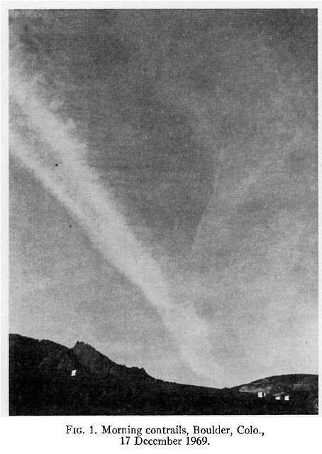
Contrail development and spreading begins in the morning hours with the start of heavy jet traffic and may extend from horizon to horizon as the air traffic peaks. Fig. 1 is a typical example of midmorning contrails that occured on 17 December 1969 northwest of Boulder. By midafternoon, sky conditions had developed into those shown in Fig. 2 an almost solid contrail sheet reported to average 500 m in depth.

Airborne Observations of Contrail Effects on the Thermal Radiation Budget
Peter M. Kuhn
Journal of the Atmospheric Sciences
Volume 27, Issue 6 (September 1970) pp. 937–942
(Click on any of the images in this article for a larger view)
Then a few years later, in 1975, we have the article : Multiple Contrail Streamers Observed by Radar, which again has photos (taken in 1971) of spreading and persisting contrails, as well as extensive discussion of these observations.

Multiple Contrail Streamers Observed by Radar.
Konrad TG, Howard JC (1974)
Journal of Applied Meteorology:
Vol. 13, No. 5 pp. 563–572
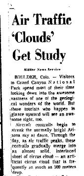 Here’s a description from 1970, from a local newspaper, the Arcadia Tribune, April 29, 1970:
Aircraft contrails begin to streak the normally bright Arizona sky at dawn. Through the day, as air traffic peaks, these contrails gradually merge into and almost solid interlaced sheet of cirrus cloud – an artificial cirrus cloud that is frequently as much as 500 meters deep.
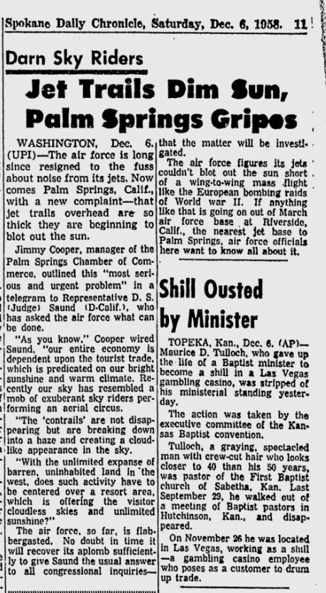
 One of the earliest reference to contrails covering the sky is from the Mansfield News Journal, August 11, 1957, Page 29:
“Within the past few years, the weather bureau has begun to report the trails as actual cloud layers when there are sufficient trails to cover a portion of the sky.”
Here’s a description from 1955:
http://news.google.com/newspapers?id=SosSAAAAIBAJ&sjid=pvYDAAAAIBAJ&pg=851,1486793
An extremely persistent con trail might stay in the sky all day
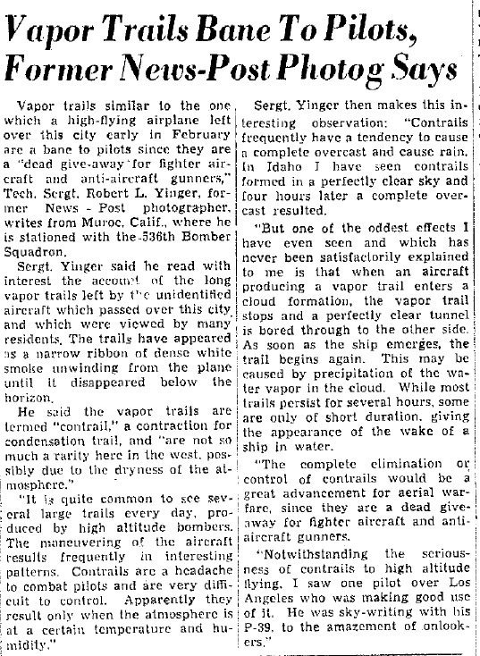
But even earlier, and with a perfect description of what “chemtrail” theorist claim cannot happen comes this account from 1944:
The News, Frederick, MD, March 7, 1944
“Contrails frequently have a tendency to cause a complete overcast and cause rain. In Idaho I have seen contrails formed in a perfectly clear sky and four hours later a complete overcast resulted“
Below is the entire top of the page of that newspaper, in case you want to look it up.

And from the book “Flight To Arras” by Antoine de Saint Exupery, written in 1942 about a military mission in 1940:
The German on the ground knows us by the pearly white scarf which every plane flying at high altitude trails behind like a bridal veil. The disturbance created by our meteoric flight crystallizes the watery vapor in the atmosphere. We unwind behind us a cirrus of icicles. If the atmospheric conditions are favorable to the formation of clouds, our wake will thicken bit by bit and become an evening cloud over the countryside.
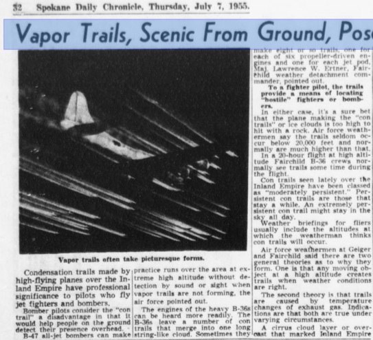
Another from 1958
So, are the right conditions for these persistent, spreading contrails cold and humid air? What if it’s warm and dry? Does this still happen?
Yes, it needs to be cold and humid, but see #4 here:
https://contrailscience.com/contrail-gaps-and-other-questions/
And Myth #2
https://contrailscience.com/chemtrail-myths/
Obviously the temperature at 30,000+ft. is always cold regardless of the temp on the ground. So exactly how cold does it have to be for the contrails to persist and spread? I’m asking this because I’ve seen the sky full of persistent trails during 85 degree days and none at all during 30 degree days. It just seems like it would be warmer up there when it’s hot down here, and cooler up there when it’s cold down here. Wouldn’t it be more likely to see them on cold days as opposed to hot days?
It varies. Check:
http://www.usairnet.com/cgi-bin/Winds/Aloft.cgi?location=SAN&Submit=Get+Forecast&hour=06&course=azimuth
Temp aloft often has no relation to temp below, esp with overlapping air masses.
> Obviously the temperature at 30,000+ft. is always cold regardless of the temp on the ground.
Ah, yes, but is is cold enough?
see http://ams.allenpress.com/perlserv/?request=get-document&issn=1520-0450&volume=036&issue=12&page=1725
Sometimes its not cold enough, and then you won’t see contrails.
The same paper explains persistence of contrails.
These appear in our So. Cal. skies & spread as they fall toward the earth even during warm days, two planes flying at what appears to be simular altitudes ones condensation trail will disipate within seconds while the others trail will persist for nearly an hour as it gravitates toward the ground, this is no conspiracy…..
Chemtrails are REAL, as to what and why I really would like to know….. Flouridating our water supply, thimerosal perservatives in our vaccines & flu shots, why not poison in the skies, nothing seems to amaze me anymore.
I live in Hollywood and work from home – I often step outside to take breaks from work and am very familiar with the various flight paths visible from my house. When I see planes with ‘contrails’ that hang in the sky long after their departure, it is ALWAYS the case that these planes do not follow the standard flight paths over Hollywood – I really have no interest in the ‘science’ of what this site proposes – what I do have an interest in is what I see with my own eyes on a very regular basis.
bigdoghat, I live about 15 miles from you, on the coast. Today (Jan 31) there are a lot of persistent spreading contrails, but I’m bamboozled as to how you can tell what a “standard flight path” is over this region – we have a very busy airspace, and a lot of traffic flies over us in many directions.
I suspect what you think are the “standard flight paths” are actually the traffic that is inbound and outbound to and from LAX (and maybe Burbank). That’s quite understandable. When I’m watching television, I can look up out of a window, and see planes flying into LAX on the exact same route, I also see planes departing LAX along a consistent set of paths.
However, those are not the planes that make the contrails. They are too low. The planes that make contrails are much higher up, going between different airports, and on a much less well defined path. They are also MUCH harder to see when they are not making contrails.
I understand your lack of interest in science. What you can see daily is obviously far more engaging. However, if at some point you want to actually understand what you are seeing, then it really helps if you can use a bit of science.
What about the projects the government has admitted to? The science explained here is fantastic, but none of it addresses the secret things the military admits to, but fails to fully disclose.
I’m not sure what you are referring to – but the government “admitting” to one thing has no baring on this subject. The basic facts are simply that these trails look exactly like contrails. Sure, anything is possible – but it does help to have some evidence on something before you start to believe it.
mp norman baker pressured uk gov they released report where they admited spraying all sorts bugs metals stuff that was seen by gov as chemical warefare, the gardian did a report on it and have recently removed the page, gov said it was SAFE, spokes person at porton down when asked results of project, said, its not our policy to comment on ongoing projects, it was in 2002, i must try and get a copy.
http://www.care2.com/news/member/733929969/444184
you can get most of the details from this vid,
Sxx
Or from the original article:
http://www.guardian.co.uk/Archive/Article/0,4273,4398507,00.html
Again, what does this have to do with “chemtrails”?
SoCalChems: “…Flouridating our water supply…”
General Jack D. Ripper: “Fluoridation is the most monstrously conceived and dangerous communist plot we have ever had to face. ”
Maybe it’s time to start plan-R
🙂
I have an offgrid PV power system in the Sierra foothills, and I’ve seen days
with (literally) SCORES of persistent criss-crossing contrails by noon.
By 2:00 PM, these have formed a layer of cirrus clouds that is reducing my
solar flux by at least 25% (I’m estimating here).
What effect does this have on a large solar power station like, say, Nevada
Solar One, which is probably seeing much the same sky as I am? What about
effects on the weather? I’ve read that cirrus clouds actually warm the earth,
because they trap more heat at night than they reflect during the day. Would
this tend to exacerbate global warming?
Would you expect all these effects to increase in the future, in keeping with the
increased number of contrails over the past several decades as mentioned above?
Good question, there is a lot of science related to that questions here:
http://www.grida.no/climate/ipcc/aviation/038.htm
It will certainly increase if nothing is done about it. This has been discussed for decades, like in this paper from 1970:
https://contrailscience.com/files/1970-AMS-i1520-0469-27-6-937.pdf
It does vary by location, with drier areas being less affected. But it’s certainly a factor for future solar power. The problem is it would take significant political will to create any kind of change.
Perhaps more of an issue is “Global Dimming”. Both man-made, and volcano made. Look up: decreased pan evaporation.
Thanks for the links. The IPCC article is particularly interesting–
apparently Feb/Mar is the worst time of year. I’ll keep reading!
interessting site! however, could u please elaborate some more on JP8 fuel and the use of additives such as aluminum and barium in millitary jetfuel? u see ive been to a local AFB and found a hughe emtpry tank there, next to the fuel-tank cars, and i retrived a sample of whatever was stuck on the bottom of the tank. it was a white sticky substance. it was obvious it had been used as an additive in the jetfuel and i live in an area with daily persistent trails (in europe that is) anyways, ive gotten the sample analysed and you can see the reults here:
http://internet.phobic.no/chemtrail.pdf unfortunatly i couldnt afford a full spectrum analysis, but at least they found what i was looking for.
I think the problem with your arguments is: “it was obvious it had been used as an additive in the jetfuel”. How exactly do you know this? Did you see it being added?
If this was an additive, then don’t you think that’s rather a minuscule amount of aluminum? After being added to the jet fuel, mixed in the atmosphere, and diluted by rain, the dilution would be FAR less than is found in ordinary ground water. Both aluminum and barium are naturally occurring minerals that are always found in the air and ground water to some degree.
When you say “stuck on the bottom of the tank”, do you mean the outside of the tank? What metal was the tank made from?
I suppose Uncinus will try to tell us that flouride is safe to ingest also. Is it just me, or does anyone see how obvious his agenda is on this blog? He has a misleading web link to refer to after every lie as if it is some kind of evidence to back up his explanation about what we are seeing. Very vigilant about attempting to debunk anything that does not conform to his false propaganda. How dare you try to tell me that what I see with my own eyes and physically experience on a daily basis is not really happening. You have made it obvious that you are going to stick to your ridiculous explanations even if the poison were sprayed directly in your face. The things that Uncinus says are so ridiculous that it is an insult to my intelligence. Perhaps Uncinus lives in an area that is chemtrail free and he actually believes what he says because he does not know any better. If so, then I want to know why his home is not subject to these chemical warfare attacks, which by the way are perfectly legal as a result of of this little gem:
PUBLIC LAW 95-79 [P.L. 95-79] TITLE 50, CHAPTER 32, SECTION 1520 “CHEMICAL AND BIOLOGICAL WARFARE PROGRAM” “The use of human subjects will be allowed for the testing of chemical and biological agents by the U.S. Department of Defense, accounting to Congressional committees with respect to the experiments and studies. The Secretary of Defense [may] conduct tests and experiments involving the use of chemical and biological [warfare] agents on civilian populations [within the United States].”
How does something as inhumane as this even become a topic of discussion yet alone a law? Did the public vote on this?
Rudedog, section 1520 was repealed in 1997. It has not been law since well before the chemtrail community came into existence.
The replacement law, 1520a, requires informed consent from all human test subjects.
http://caselaw.lp.findlaw.com/casecode/uscodes/50/chapters/32/sections/section_1520a.html
I’m not saying that what you are seeing is not happening. I’m saying you are mis-interpreting it.
Hi Uncinus,
Great website and good work on showing the true nature of contrail characteristics. It is too bad that the chemtrail websites do
such shabby work on how contrails have spread, persisted and existed long before the current ‘mania’.
Now lets touch on a few other points of interest. I am highly curious of your current knowledge of these data points as they are public record and have been available to your keen mind for many years.
1) chaff has been utilized for years as a way of jamming enemy radar by the military. This chaffe is released as an aerosol from
aircraft. Do we have any disagreement here?
2) In 1993 ‘chemtrails’ (ugh, sorry to use such a loaded, controversial and mis characterized term) were deployed over Iraq in the
first ‘Gulf war’ for radio communication purposes. This use of contrails by the military is a direct application of a very real and in use patent on aerosol operations. The metals included both aluminum and barium. Do we have any disagreement with this?
3) Spherical orbs are often seen by those who closely observe contrails. These orbs appear in the sky very close to recently laid contrails, many actually appearing inside of the trails. These orbs are very prevalent in the skies above California, definitely above Los Angeles and Inland communities. I have seen and recorded these orbs myself and do not have any idea what they actually are, nor I have any idea what their purposes are. I am intensely curious if you have seen them yourself, and any thoughts that you may have as to their origin, purpose and keen fondness for contrails.
I do really appreciate the detailed analysis that you have presented on your website regarding contrail characteristics and look forward to your reply on some very real activities of something that legitimately could be termed (ouch, once again) chemtrails.
Oh, btw… of course I have links that support an established public record to all 3 points made, but my curiosity as to your existing knowledge of all 3 is just too great …
Very Truly,
Bryansail
1) chaff is not really an aerosol. Originally chaff was small strips of aluminum foil – this is no longer manufactured, but still in use. Modern chaff is made from glass fibers coated with aluminum. The fibers are 0.3 to 2.0 inches long, they are not suspended, and will gradually fall to the ground. An aerosol is “a suspension of fine solid or liquid droplets in a gas”. General use of “aerosol” refers to things like a fine mist, or smoke particles. While it might be technically correct at a stretch, using “aerosol” to refer to chaff is likely to confuse people, and you would be better to more accurately describe what you are talking about. See:
http://www.globalsecurity.org/military/systems/aircraft/systems/chaff.htm
2) I’m not familiar with any use of contrails in the first gulf war for communications. Can you provide some links to back this up?
3) I think the orbs are various things: birds, planes, landing lights, planets, balloons, plastic bags, even the occasional weather balloon. People looking at the sky a lot, like UFO watchers, or “chemtrail” theorists, will eventually see and record these normal objects, and think they are somehow connected to the things they are looking for. The clearest evidence for this is the total lack of any detailed photos. All we ever see are a few blurred pixels that could be anything, whereas there are many thousands of detailed photos of planes at high altitude.
“Orbs” could also be thistle-down. Check the dates of photos… late summer? Yes. Thistle-down.
Uncinus,
1) chaff can be an aerosol. The patents are numerous for aerosolizing metals. We have record of metals in liquids being dispensed already. Modern chaffe can also come in a liquid state suitable for deployment behind airplanes as seen and utilized in the first Gulf war, back in 1991. Aluminum oxides are confirmed in use within numerous govt documents on aerosol chaf ops. Aluminum in high concentrations are very bad for life forms and should be looked at as a concern for all who breathe, eat etc.
Some specific patents for spreading metals as an aerosol are USP 4948050 filed 8-19-1990, USP 5003186;Stratospheric Welsbach Seeding for Reduction of Global Warming, Hughes Aircraft Company, issued March 26, 1991, USP 4948050 as well as other patents dating back to the 1970’s. Analysis of these patents can be found numerous places and are necessary in the context of the Navy program that I mention below.
http://www.scribd.com/doc/3098564/chemtrails-a-research for examples of aerosol patents. Stated uses of these patents expand outside the realm of use of chaff, very easy to see how they are utilized for military operations. It is also a very real way to disperse this ‘harmless’ chaff in a classic aerosol form since we
are quibbling over the definition of ‘aerosol’ apparently.
Excerpted from the ASP (atmospheric science program website archive page;)
http://www.asp.bnl.gov/Archive.html –
‘The primary goal of this campaign is to characterize and contrast freshly emitted aerosols above, within and below fields of cumulus humilis (or fair-weather cumulus, FWC) and to use these observations to address how below-cloud and above-cloud aerosol optical and cloud nucleating properties differ downwind of a mid-size city relative to similar aerosols in air less affected by emissions. The observations from this campaign will also be used to aid in the development and evaluation of parameterizations of the transformation and transport of these aerosols by FWC for use in regional-scale and Global Climate Models. This final product has the potential to reduce the uncertainties associated with the treatment of aerosols by these models’
This is an example of public record pointing to aerosol dispersion by our Government for climate modification.
The study states that they will be observing freshly emitted aerosols (not disclosed what type) and then
developing and USING these aerosols. Not hoaxed is it Uncinus ? I would be in complete agreement that it is unknown how widespread and how utilized these programs are but last I checked we had a fairly robust military budget that IS interested in 3-D mapping of war zones and technological advantage over enemies.
Curious Uncinus if you are familiar with United States Navy’s RFMP, Radio Frequency Mission Planner, military program. Here is a hint for you, barium salts, ‘ducting’ and 3-D mapping are involved. Hope that I am not being ‘mis-leading’ by mentioning this Navy program. Are you ready to admit that aerosol programs are already in use ?
As for my links on contrails being used for over the horizon radio communications during the US Gulf War I, I am looking for a link that is still viable, got a few 403 not found and re-directs so far, I will find a decent link I hope, just have a time crunch at the moment. Nick Begich, in his book Angels don’t play this HAARP discusses the use of contrails for radio communications during the first Gulf war, but I’ll re-post with some web data for you very soon.
As for the orbs, numerous websites detail them, but keep looking up as I am confident you will see them yourself moving through contrails. Take photos of contrails to see them sooner, indeed they do appear as
points of light without magnification and I couldn’t rule out plastic bags or weather balloons at this point. I
do believe that they relate to aerosols but would like better evidence definitely.
-Bryansail
USP 4948050 mentions nothing to do with radar, it’s simply aerial spraying, like crop dusting, or spraying insecticide. Nothing to do with chaff.
The ASP quote has to do with air pollution in cities, and how to treat that, nothing to do with chaff, or contrails.
You don’t have any links for gulf war usage of contrails for radio communications.
Show me a link of an orb video that demonstrates that the orb is NOT one of the things I listed.
”I really have no interest in the ’science’ of what this site proposes – what I do have an interest in is what I see with my own eyes on a very regular basis.”
hmm, i have interest in what i see on a very regular basis. the earth is flat and the sun and universe orbits us every 24hrs. this is true right because what i see is always what it is. right? haha, chemtrailer logic. i guess if they have no interest in the science then i guess their cold winter breathe is a secret government chemical breathing operation hey…oh boy these chemtrailers are too funny sometimes.
u have great composure and paticence to keep answering their same old same old questions uncinus. keep up the good work! brilliant site!
I have watched this going on now.. here in SanDiego…. over to Borrego.. DAILY, for some time. There is a difference between contrails, and the stuff I am talking about.
This has nothing to do with contrails.. this is done by jets that fly very high.. and they sometimes circle back and forth..
Criss cross etc. It is NOT contrails.. it’s something else, and we sure would like to know who’s doing it.. and why.
People are getting mad.. and more and more people are taking pics.
Am in touch with friends in Europe who are doing the same thing. We are gathering evidence together.
And we are contacting all: Congress, Senate, FCC… every and all agencies we can think of.. o yes, and of course, the media.. who has been silent on the subject so far.. but no longer can be.. because the pressure from the viewing public is getting too great.
After all, if we don’t watch their ” news ” anymore.. or anything else they are showing us, they will go broke.. right ? !
Addie, how exactly do you know that what you are seeing is not contrails? Have you read the descriptions of how contrails are supposed to behave? There are lots of books on clouds that describe how contrails can last for hours, and spread out to cover the sky.
Jet do NOT circle back and forth except when in a holding pattern. The majority of what people claim to be jets flying back and forth are actually different jets flying in opposite directions of the same airspace.
Hardly anyone believes in chemtrails. Most people don’t pay much attention to the sky, and when they do, they can quite clearly see that these are normal contrails.
Uncinus, I thank you for your reply.
Allow me please to disagree with you, these are not contrails.
And Most people ARE upset about them, the ones in my neighborhood surely !
We feel.. it all has to do with HAARP. just no one knows. what !
My car is covered w. a sticky layer, every morning.. right after I wash it.I have developed an unexplained respitory illness, during the last year.
On and on….
No.. these are not contrails.. something is being sprayed into our atmosphere !
The biggest clue to that it’s not ok, and it’s not contrails, is the fact, that you can’t get an answer from : Your Senator, Congressman.. Media.. etc.. because I have written about 20 letters, to this day.. with not one reply.
When I am Stonewalled, I know I am on to something. and I am being stonewalled.
I am in touch with friends in Europe, who are observing the very same things.
Thank you again for your reply.
Addie.
Briansail. what are ” Orbs”? As much as I am watching this weird phenominan, I have never seen orbs.. maybe because I don’t know what they are?
Explain please ?!
Thank you,
Addie.
Addie, cars being covered with sticky layers are not at all unusual – it has to do with the local plant life – usually pollen, or tree sap. Do you park near a tree?. Unexplained respiratory illnesses are also not at all uncommon – you might even be allergic to some of that local plant life.
What is odd is that you choose to connect these to long lasting contrails, of the kind that we can see have been appearing in the sky for 50+ years, and are well explained by science.
Being ignored by your congressman for writing letters about a conspiracy is not evidence of a conspiracy.
Orbs are things high in the sky that people mistake for UFOs, things like balloons, birds, aircraft, wind-blown littter, clouds, stars, planets, etc. People video them, and zoom in so much all you see it a couple of pixels.
If you start looking for orbs, you will see them. It’s the same process for “chemtrails”.
Uncsinus.. please now.. tell me the truth !
Who is paying you to debunk the facts?
Who are you working for ?
Meanwhile we have studied more details on HAARP.. and found connections to the ” mysterious ” “Con”-trails !
I thank you for responding to me, I really do, but for some reason ( and I am very smart, am told !) I do not trust you.
Par Example : 10 years ago, one did not see such weird things in the skies.. correct? Of course you will say that is because we had less airtraffic or something like this.
It does not seem to matter what I say.. you have an uncanny talent to make me sound like a nut.
It’s ok, we know what we know.. those are not contrails .. dear Unc.. them’s Chemtrails !
Addie.
Addie, I wish someone would pay me 🙂 But unfortunately I’m just an amateur pilot with an interest in the weather, science, and conspiracy theories.
10 years ago we DID see exactly the same things in the sky. Page after page of documents and photographs can demonstrate this. What happened ten years ago was that Art Bell started discussing contrails on his radio show, and people started to notice them because of it.
This too is easy to demonstrate, just ask anyone who has not heard of contrails if they have noticed that contrails last a real long time. If they have not, then ask them if they ever remember contrails lasting a long time before last year. They won’t, because they never noticed them at all!
That just like you. When did you first notice them? What year? Why are you any different to the average person?
You don’t remember what you don’t notice. Nobody does. If you did not notice persistent contrails, then why would you remember them?
And why would you choose an explanation the flies in the face of all known science? Why not simply “I did not notice persistent contrails before people started talking about them”?
your last sentence is entirely wrong !
I am a sky-watcher, as in, I love to watch nature.. and I look up.. always have.
I noticed these trails.. on my own.. did not read or hear anything about them at all.
I NOTICED them.. about 6 months ago.. when I noticed a jet making them. Then he turned about, and crossed his own trail. This caught my interest ! I kept watching. Then I noticed. that said trails would not dissapate.. but instead.. not only linger, but spread.. and hazed up a good part of the sky. Now, I was curious, and began to really really watch. Since then.. I see when up to 2 planes at a time.. leave the trails.. criss cross them.. and when they are empty, and have to land somewhere.. the sun is reddish.. as if being obscured by oily Goo.
I am not the person, that depends on others to call my attention to things, I am very inquisitive and like to research things that I notice.
Never did I hear a talk-show on the subject.. ever.
Maybe you are correct and this has been ongoing longer than 10 years and if indeed it did, then I did not notice.
But.. now that I have, I am greatly perturbed and just do not believe this phenominan to be ” normal ” but connected to something Bigger.. namely HAARP. The latter.. is a guess ! By the way, my deceased hubby was a pilot, so the skies always were of interest to me !
Thank you for your time !
Addie.
Addie, you say “this” has been going on for ten years, yet you yourself only noticed it six months ago.
That means that YOU DID NOT NOTICE IT for nearly ten year.
So why would you have noticed it before?
Perhaps it’s simply normal contrail that have been in the skies in increasing numbers since the 1940’s, and you just one day noticed them.
If not, explain why you did not notice them for ten years, and how this differs from the previous thirty years or so when you also did not notice them.
Very good question I can not answer.
It’s weird ineed, you got me there.
Maybe because they weren’t there??
I suppose that is the reason.
2 weeks ago, I was really skywatching.. and followed those trails ( am avoiding the word Chemtrails to not upset you ;o)
to Borrego Springs. The skies were covered w. them all the way.. criss cross.. criss cross.. all the way into Imperial Valley.
Did not look like ordinary jet-traffic to me, but it was rather weird looking and the sun shone reddish.
Whatever happened to ” Blue and Gold” gorgeous Southern Cal?
my beautiful California… w. streaked skies.. just not the same..
Overall.. I wish nothing more, than that you were Right !
Addie..
Uncinus, The conditions in the sky above are random and ever changing. Specific conditions are needed for a jets exaust to leave a thick persistent contrail. While I can’t measure the length of these contrails, where is the randomness? When several jets appear to be covering a section of sky with paralell or intersecting contrails, why do they appear to be of similar lengths, where is the randomness?The contrails are never short, 1/4 or 1/2 mile etc., and they are never long, horizen to horizen. Mother nature is random, tank capacities are not. A jet can only carry a given amount of fuel additive, which is switched on in coordination with nearby jets, hence the reason chemtrails are similar in length.
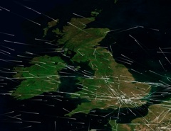
You might want to look at some satellite photos. The length of contrails comes from the size of the region of moist air they are traveling through. This can be quite short, but typically is in regions sized fifty miles and up – hence the common sizes you see.
See here for some examples, and please check out MODIS in your area to get a better overview:
https://contrailscience.com/contrails-above-and-below/
MODIS:
http://rapidfire.sci.gsfc.nasa.gov/subsets/
Uncinus, you say”The length of contrails comes from the size of the region of moist air they are traveling through” which is correct for true contrails(water vapor). So how come there are no extremley short persistent contrails, and why aren’t there any that cover the whole visable sky? Jets remain at constant altitudes for much of thier flights, and I have seen jets leave normal dissappearing contrails horizen to horizen many times. How come these persistent contrails(chemtrails imo) are never that long? Does mother nature only make one size persistent contrail length moist air region?
There are both kinds of contrails. Google for “broken contrail” to see the short kind, and just about any “chemtrail” site has photos of the long kind.
Of just look through the satellite photos for a while. There are all kinds of lengths of contrails there.
Uncinus, today we had both kinds. Real clouds and Chemtrails.
The difference was very obvious.
All of us are breathing that stuff including you.. why the denial?
Sooner or later, the truth will prevail.
The more people are getting upset about it and write letters and more letters, the sooner somebody is going to have to tell the truth.
And maybe.. just maybe a few honeybees will survive and start pollinating, because our foodsupply is in grave danger.
Oops here I said it, yes, I think it’s the Chemtrails that killed our honeybees !
Rudedog’s comments are excellent, and right on.
I did not know about ” Public Law 95-79 ”
wow, I had no clue, thanx rudedog !
You say the difference is obvious.
But what is the difference?
the weatherclouds were roundish, puffy,soft.. almost luminous looking.. while the other ones were edgy, ragged torrn.. and streaky.
The most noticable thing was.. they were higher than the others.
Also they appeared in certain intervals.. while the real clouds were totally random in locale..
.. as good as I can describe it…
Perhaps you could show a photo to show what you mean? It just sounds like normal variations in clouds to me.
Of course contrail clouds are going to be a bit different to real clouds, they are artificial. So I’m not sure what you point is.
How could you tell they were higher? Do you have a photo or video?
Uncinus.. guess what ! I just came home from my Dr.. hear hear what she said :” All those upper respitory problems and stinging eyes.. it’s increasing so much.. and it’s those Chemtrails causing it “! Quote unquote, and I am no liar !!!!!
Addie.
P S.. sorry I don’t have a video-camera.. can’t comply w. this request.
Addie, I’m afraid that what your doctor tells you is not very useful in terms of evidence. We’ve no way of knowing just what you doctor is basing here assumptions on, or what method she uses to arrive at this conclusion.
What you need is actual evidence. Like some numbers.
How come planes flying at the same altitude at the same time do not all have ‘contrails’. Or why do airplanes start ‘contrails’ at a certain spot (always the same spot) and stop ‘contrails’ a minute later! Why do ‘contrails’ not dissipate in all direction put often have a spine and a thin haze is pulled out of this spine away from it, always in one direction?
I think you are a debunker.
Chemtrails are real, make people sick and are being used in conjunction with HAARP and cellphone towers (amongst others) to make people ill and manipulate the whether! I don’t want any kind of spraying going on where I live. So stop!
Hi Peter Pan. I think all your questions are answered here:
https://contrailscience.com/contrail-gaps-and-other-questions/
Thank you Peter Pan.
I was getting tired of arguing, because indeed he is a debunker.
The rest of us know that it’s true.. those are Chemtrails.. and they are making us sick.. period.
I also agree with the Haarp-connection.. and celltowers.
As to what to do? Talk to as many people as you can.. even when you are out and about.. call it to the attention of strangers.. have them look up, you will be surprized how many people don’t have a clue.. Yet !
Addie, yes, you should talk to as many people as possible. Most of them have never noticed these persistent spreading contrails – or at least not paid them much attention.
But why would that be? Why have no scientists noticed this? Why no meteorologists? Why no mainstream journalists? Why no local politicians? Why has hardly anyone noticed these persistent spreading trails?
Could it be perhaps that nothing is new? That these trails have always been like this? That people are not noticing it because NOTHING HAS CHANGED?
Can you provide on shred of evidence that contrails were actually different ten years ago? One sentence written somewhere that describes how contrails SHOULD behave? Because I’ve looked, and all I find are descriptions of contrails dating back to 1940 that describe exactly what we are seeing now.
Nothing has changed. Contrails have always acted like this. You just started noticing them one day, and it went from there.
3 days no Chemtrails.. blue skies.
This is weird.. I wonder if there was absolutely no airtraffic for those 3 days??
No one flew over us? Strange indeed.
We are near a large airport and several small ones.
And not ONE trail in the sky.. ummmmm, it must be the weather !
Exactly. It’s the weather.
I ” jubilated” too early, just came home.. and here.. from the East, mind you, the East.. come creeping the Chems.. stripy. criss crossing the skies. We have westerly winds, so I don’t understand.. how this stuff can move from East to West. Unless of course.. they are higher.. than the winds are blowing.
They will be here overnight.. slowly creeping along.. covering the skies by midnight. Have seen this be4… so I know how it will go.
Where do you live Addie?
I’d urge you to check two things, firstly the weather AT CONTRAIL ALTITUDE (25-35000 feet), which you can find here:
http://www.usairnet.com/cgi-bin/Winds/Aloft.cgi?location=SAN&Submit=Get+Forecast&hour=06&course=azimuth
Just pick your closest city from the box. Then note the wind direction, the wind speed and the temperature at those altitudes.
Then check the satellite photos from MODIS, here:
http://rapidfire.sci.gsfc.nasa.gov/subsets/
Scroll down to the map of the US, and pick the region that covers where you are. The photos are taken around noon, and post a few hours after that. There are two photos a day. Fo example, here is todays:
http://rapidfire.sci.gsfc.nasa.gov/subsets/?subset=AERONET_La_Jolla.2008214.terra.1km
You can press “prev” to go back a day, as far as you like, to see the kind of condition that you get contrails in. There have not been any around here for a long time.
in San Diego..
I was looking east.. toward Borrego.. and there.. over the hills.. creeping westward.. came the criss cross stripes.
I will look up what u gave me, thank you.
See the high res satellite image for today:
http://rapidfire.sci.gsfc.nasa.gov/subsets/?subset=AERONET_La_Jolla.2008214.terra.250m
You can see the band of moisture coming up from the south.
thank you.. interesting pic..
Yes.. I see moisture coming in from the ocean.. and also from the east ( originating in the south I think ). But Uni.. look, there’s a diff, between those real clouds.. and those, that are lines that spread out.. even criss cross eachother, ah.. I am done discribing it. There’s just no way that you don’t know what I am talking about. You MUST see what I am seeing…… so please Uni, for Truth sake.. Please..
lets have honest exchange here.. because we all are breathing the same stuff.. and we should help eachother.. and not try and prove to be ” RIGHT” ! Something is going on, that isen’t normal, just not.
Have u ever checked out HAARP ? What do you think about that?
I am not interested in argument.. only in getting to the bottom of things.. I would like nothing more.. than peace of mind about this issue. I say.. something is wrong.. you say .. not.
I am no scientist, or pilot, but I can S E E.. ok?
Right now.. real clouds ( ocean-moisture ) is moving in.. and pretty soon it will cover the skies.But what I saw in the East.. were not clouds.. Uni.. just not ! Sorry to be so lengthy.. will try and keep my comments shorter.
Addie, what you saw were contrails, they spread out and crisscross each other – always have.
Contrails form and persist when there is enough moisture in the air.
The clouds in the satellite photos showed that there was moisture in the air.
So what do you see that is “not normal”?
I will make one more comment, ok?
If good people do nothing, they deserve whatever it is they are getting ! As for me, I have been given a conscience and a brain.. so, I am writing, to all agencies and medias I can think of.. and let it fall where it may.
One thing I will not do.. be silent !
As for me and my house, I will serve the Lord !
And He told me, to stand for what is right and honest and honorable.
I can not be deceived, I know what I know, and I see what I see.
It was interesting to have this discussion and I thank you for your time. We are not going anywhere though, so it has become meaningless, and a waste of time.
If you LOOK again, and start to open your eyes real wide, and should see. what others are seeing.. well.. then, let me know.
Addie, I didn’t “do nothing”, I actually did quite a lot – wrote several articles here looking at the evidence presented behind the “chemtrail” theory, and subjecting it to careful analysis.
A discussion should be about collectively examining the evidence, and attempting to discern what theory best fits the facts. I think I’ve shown that the clouds you are seeing are just contrails, and are not unusual. You’ve not presented anything contrary, other the usual “looks odd to me”.
You’ve got to look at the science. Contrail Science.
Aug 6th..
I just took pictures over the skies in SanDiego.
Criss crossing whitish.. and a black trail.. Plus
several small ones. It started in the eastern sky over the desert and w.in 2 hours.. it was over my house ( near the ocean ).
Winds are west to east.
These Chemtrails travelled from east to west. They always seem to do this.
It’s heavy today, and this time I have 20 pictures to prove it.
NOPE them’s no Contrails ! Yuck, we will enjoy breathing that poison..even our flowers are hanging their heads, not joking.
Our wonderful golden California sun.. is obstructed and looks red.. and it is cooler than normal for August.. our hottest month.
Hi Addie, I’d like to look at your photos, can you post them somewhere? Or email them? I’m always interested in examples of “black trails”.
[email protected]
Check out the weather today in San Diego.
http://www.usairnet.com/cgi-bin/Winds/Aloft.cgi?location=SAN&Submit=Get+Forecast&hour=06&course=azimuth
The wind ON THE GROUND is coming from the west, but winds at altitude are coming from the south and the east, sometimes in the opposite direction to ground level winds.
Today’s satellite photo is not up yet, but it would be interesting to compare it to your photos when it is posted
http://rapidfire.sci.gsfc.nasa.gov/subsets/?subset=AERONET_La_Jolla
Addie, there is nothing you can say that will make this jerk admit the truth. He created this website for one purpose. That purpose is obvious to anyone that is not a mindless drone. He has the advantage because too many people are afraid to think for themselves. They would rather believe that what they are seeing is what uncinus tells them they are seeing rather than believe their own eyes. It is a much more comfortable world for them to live in as long it can be explained through government sponsered science. Therefore, since uncinus has an explanation for everything, we are all just nut jobs with a conspiracy theory.
Have you ever noticed that all of the articles that uncinus refers to originate from the source that would want this sort of thing covered up if it were going on? Are people so naive that they believe their own leaders would never mislead them? Get real!
I can see how you might thing that back in 1970 NASA might be planning to blanket the world in contrails for some reason, but you also think the Encyclopædia Britannica wants it covered up?
And the Mansfield News Journal, August 11, 1957? They also are part of a cover-up?
https://contrailscience.com/images/L/1959+mansfield-2.jpg
I’m not sure why you bristle at your theory being described as a “conspiracy”, as clearly for it to be true, there would have to have been some quite incredible conspiring over the last 60 years.
I actually encourage people to think for themselves. I encourage you to do it, if you will humor me for a moment – tell me how do you know that contrails rapidly dissipate? Is there ANY science book that actually says this? Any written thing at all that says that contrails don’t ever last more than a few minutes?
to Rudedog : My sentiments exactly, thank you.
Yesterday our skies were a nightmare again.. heavy streaking from East to West.. smartly layed right in front of cumulous-desert clouds, so it would look as if they ” belong” Well… the diff between real and Chem is so very obvious.. people were not fooled for a sec.
We stood outside and took pics.. about 15 neighbors and myself.. we all are writing letters. Not that they will do any good.. but.. we have been heard, this we know.
So far.. today, our skies are clear.. our beloved Blue and Gold California skies !
Have a look at the big picture Addie:
http://rapidfire.sci.gsfc.nasa.gov/subsets/?subset=AERONET_La_Jolla.2008220.aqua.500m
That’s the satellite photo for yesterday, showing SoCal down to Mexico, you can see there’s a big band of clouds to the east of San Diego. That’s what they are, just clouds. Nothing unusual.
Here’s a wider scale photo:
http://rapidfire.sci.gsfc.nasa.gov/subsets/?subset=USA5.2008220.aqua.1km
It’s just clouds. That’s what they look like.
Thank you.. great pix..
Do you have a clue what happened here today? ALL day ALL night.. Jets flew over us ( yes I watched them ) and blasted their poison into our skies and I mean.. ALL of the sky was covered, and the sun shone bloodred !
They criss-crossed.. and those trails expanded and expanded.. people were staring at the sky. We all started talking and I think.. about 100 letters will go to Senators and media today.. we are so sick of this. We want to know What they are spraying and what it does to us.. today was the worst Ever.. and I have too many witnesses to count , all of them, or most.. making videos of this unbelievable mess..
we are angry and demand an answer.
I called a congressman’s office and registered a complaint, we shall see…
Addie, IT’S THE WEATHER, look, here’s the satellite photo for that day from around noon. You live to the left of that lake in the middle of the picture:
http://rapidfire.sci.gsfc.nasa.gov/subsets/?subset=AERONET_La_Jolla.2008225.aqua.500m
See all the wispy clouds? That’s moisture in the air. Planes fly through that air and leave contrails. There’s a few persistent trails on the right.
Check the previous day:
http://rapidfire.sci.gsfc.nasa.gov/subsets/?subset=AERONET_La_Jolla.2008224.aqua.500m
Less moisture, less contrails.
Uncinus, can you please explain what is happening in the youtube video “Chemtrails ?? watch for yourself “. Please bear with the terrible audio noise in this video.
http://www.youtube.com/watch?v=QqZQjxCW3U4
It’s a sky that’s overcast with the remains of several contrails.
A plane is flying through, makes a 90 degree left turn, continues for two minutes, then makes a 90 degree right turn to continue on its original heading.
It was probably just making a course correction – most likely as a response to Air Traffic Control to allow it to fly around traffic that was ahead of it, or to let traffic behind it pass it safely.
Thank you to Rudedog and Addie for your gallant attempts to reveal the TRUTH! Addie, did Uni-anus ever answer your question about HAARP? Of course not. I am sure he is fully aware of this organization, however, like a politician (or criminal) he will LIE LIE LIE through his teeth to protect himself or his “CAMPAIGN”! It is absolutely not a conspiracy “theory” – it is a real threat to the lives of US citizens (AND Canada and England and …?). I will apologize for Anus’s insensitivity to your respiratory problems, Addie, as I know you are suffering and my heart goes out to you (and the honeybees)! Hey, U-anus, have YOU given us any numbers??? In your so-called merry go round answers you never mentioned William Thomas’ Contrails: Pioson From The Sky and his REAL RESEARCH! How about MIT physicist Bernard Eastlund of HAARP who in 1985 was granted the patent for “directing energy beams of more than 1 billion watts can be used for altering the upper atmoshere wind patterns using plumes of atmospheric particles as a lens or focusing device” to disturb weather conditions thousands of miles away. Sunday, May 17, 1998 the jets were seen with their chemtrails which was immediately followed by a tornado. Or Everett Burton who when doing an interview on C-Span about the impeachment of Clinton was completely shut off when he started to mention CHEMTRAILS! Kentucky closed down schools in 5 counties because all the children were ill with flu-like symptoms (Doctors found it NOT to be a flu but a fungal infection not yet identified). For a chemtrail timeline by William Thomas check out fourwinds10.com which refers to military operations such as Operation Cumulus, Operation Popeye, oh and yeah that other “little law” aka the UN Treaty called ENMOD. To the #1-Anus (since you are the “expert”) -What are “Storm Enhancement”, “Storm Modification” and “Induce Drought” operations by the US aerospace forces to “own the weather” by 2025??? THOUSANDS are affected by these chemtrails and I can only wonder would Anus be so confident in his flimsy worthless words if HE were experiencing the painful repercussions of these chemtrails that sprinkle webs of “imaginary” Ethyl Dibromide and JP-8 jet fuel into our lungs??? Poor Anus, you are so far up someone’s ASS that you can’t recognize the truth. I will not compliment you on your site as I consider it AND YOU a web of BULLSHIT! Keep spinning. Careful of the black widow of time and consequences for your outright deception. The truth will prevail. Unfortunately, it is just as ugly and inhumane as Uni-anus has proven to be.
Hi warrior, thanks for the questions.
HAARP operates on the ionosphere which starts at 160,000 feet. Therefore there can be no connection to contrails.
I could not find any actual research by William Thomas – just some option pieces from about 10 years ago. Can you give me a reference to some research? Was there analysis?
Jet’s leave contrails all the time. Tornadoes happen all the time. It’s hardly surprising they would happen at the same time occasionally. And you just mention once occurrence from 1998? That does not seem like strong evidence of correlation, let alone causation.
If contrails are spreading this fungus, then why would only five schools in Kentucky be affected? A single contrail can affect thousands of square miles – so why only the schools? Why not the neighborhood? It seems more likely it was something unrelated – to do with poor school maintenence.
Operation Cumulus, Operation Popeye, “Storm Enhancement”, “Storm Modification”, and “Induce Drought”are all CLOUD SEEDING weather modification programs. This is nothing unusual, as cloud seeding experiments have been going on for 80 years. Cloud seeding takes place INSIDE CLOUDS. So a contrail in a clear blue sky cannot be cloud seeding.
I’m sorry if you are ill. But it seems far more likely that car exhaust would have a effect on your health than jet exhaust. Jet exhaust is the same regardless of if it produces a contrail or not – that simply depends upon the weather.
http://www.willthomasonline.net/willthomasonline/Chemtrails_Timeline_1.html
http://www.willthomasonline.net/willthomasonline/Chemtrails_Timeline_2.html
http://www.willthomasonline.net/willthomasonline/Chemtrails_Timeline_3.html
Uncinus – Oops, my mistake, it was 7 KY counties AND I only neglected to add that other victims are the elderly and the weak/vulnerable (such as those w/asthma) but I figured you already knew that! I have read the facts and have seen “the numbers”. Now, it is your turn. You can tell it is not biased because it reveals the arguments people all over (US, Canada, Germany, Europe, New Mexico) have had w/US Air Force and other debunkers such as yourself. Both sides are represented. It appears that we have a division here between those who care about human life and those like you. Read every word and TRY (do your very best) to learn something called the TRUTH! I do not have questions for you as I see you will never stop spinning your web of deceit.
My goal is that these sites will demonstrate to Addie, Rudedog and other concerned people (like myself- ill or just sick to our stomach from the facade) that we are not as stupid as you hoped. I mean, come on, orbs as “plastic bags” or “weather balloons”? Have you seen the photos? Get real.
Timeline 1 – even Sen Lieberman wrote the EPA and recieved a silent response. January 8, 2000 meat trucks used as morgues since hospitals overflow w/patients. March 2, chemtrails vanish when tankers are grounded.
In Timeline 2 read about Jan 1, 2003 when Russia seeks HAARP ban! And yes I realize tornados can occur anywhere but what does it say about hurricanes Frances and Ivan? I am sure you have a way to explain all of this away. Feb 16, town council in Greece condemns chemtrails. Canadian Petition Number 372-1644 presented to Federal Government- spinning again-point for you!
Timeline 3, read and tell me what Connie Fogal says. Nevermind, I already know since I have done my research. Dec 7 Air Force pilot admits spraying from KC-135 and KC-10s. He also states “we are not supposed to talk about it”. March 8, 2006 – lung cancers surge across US. Timeline 3 – “The term chemtrail does not refer to common forms of aerial dumping (eg cropdusting, cloud seeding or aerial firefighting)”. Let me remind you this is illegal due to ENMOD – UN Treaty “Convention on the Prohibition of Military or any Hostile use of Environmental Modification” or the deliberate manipulation of natural processes to cause phenomena such as earthquakes, tidal waves and changes in the climate and weather patterns”.
Now, you admitted yourself that crop-seeding affects the weather so you should agree on this point. Unfortunately, it really doesn’t matter what you want to call it – contrails, chemtrails, conspiracy theory or delusions, orbs or plastic bags etc etc lie lie lie! HARMLESS? Absolutely not!!! The reality is WHATEVER – (EDB, quartz crystals, barium, magnesium, aluminum) – these jets are spraying into our poor Earth’s atmosphere (AND THEY ARE SPRAYING) is detrimental to humans of all ages and will have dire repercussions to all species. Maybe someday you will learn.
Oh, and by the way, I am not ill; Addie is and thousands of others all over the planet. I just happen to CARE. Try it. It is called “empathy” or “compassion” look’m up. Again, try your very best.
The problem with William Thomas is that is writing is so full of inaccuracies and dubious eyewitness interpretations, that it’s hard to believe any of it with confidence.
He says:
Obviosly he does not check his sources, as that report has been shown to be wrong by a factor of 100. They actually found 0.03 times the allowable limits. See:
https://contrailscience.com/barium-chemtrails/
He has this photo:
http://www.willthomasonline.net/willthomasonline/Chemtrails_Timeline_3/IMAG016.JPG
Which says: “500 Km long trails … Water Vapour”
Yes, water vapor. At a normal cruising speed of 900 km/h, a Boeing 777 would only take 33 minutes to lay down a 500 Km long trail. This is not at all unusual.
Then he says:
Showing this image:
http://www.willthomasonline.net/willthomasonline/Chemtrails_Timeline_3/IMAG001.JPG
No, it’s not a refueling probe, it’s a spraying device for testing in-flight icing, as shown here:
https://contrailscience.com/contrail-or-chemtrail/
He gives no references. No statistics. No actual numbers at all. It is riddled with inaccuracies (I gave three, but could go on for hours).
I seems his entire thesis was based on some newspaper reports of overflowing emergency rooms (which you can find for every year if you look – pick a year and I’ll find some), and then a tenuous connection to contrails. He then started looking for evidence, selecting only the evidence that supported his theory.
I’m not going to wade through that mess any more that I just have. If I can find three MAJOR errors in five minutes, then it’s pointless continuing. Tell you what, warrior, why don’t you pick what you think is the ONE strongest VERIFIED FACT that you think supports “chemtrails”. Then we’ll discuss that.
Up here in Alberta, Canada i have noticed 737 type jets that have the ability to change their contrail, consistancy… also, when this happens it takes place over 30deconds! Normal ,regular contrail——Thick, long and FLAT——Normal–ect…… WHY???
It’s because they are flying through different regions of air. The atmosphere is not uniform at all. Some areas, like clouds, have a lot more moisture than others. When the planes flies through a region with more or less moisture, then its contrail will change.
Warrior, can I hug you please? You brought tears to my eyes. I am not as educated as you are.. and am amazed at your research, not to mention your compassion for me. Thank you !
I know you are correct, I have done my research also, overall the NWO-plan is, to rid the planet of the plague of people. Sadly, people are fast asleep, so ” they” are succeeding !
I grew up under communism, and immigrated to the US.. after I escaped them, when I was all of 17. I have seen much in my life, and these wonderful United States… whom I fell so in Love with when I came here.. are entering a phase.. a life, a government, that I am familiar with, because I grew up under such horrid conditions.
I still love the US, but.. what I escaped.. is following me, I feel it, and know it.
People are naive and do not want to hear. I know, and whenever I bring it up, they say that I have an overactive imagination. Well… I do not, I know Real from Fake, been there.. done it.Our weather here in CA is hot in August, but this year.. it’s actually cool.. here near the Pacific, we have not had temps higher than 78. The Norm is more like 85 to 90.
This right there.. tells me something is wrong. My family in Europe tells me, they have those Chemtrails going on too, just not as much as we do.
The last 3 days we have been Chemtrail-free, and looking at our beautiful CAL-sky the last 3 days.. I cried a lot, and thanked God for this incredible beauty, and asked Him to please protect us from all this Evil.
This is the Best I know what to do.
You, warrior, encouraged me, and with all my heart, I thank you.
Addie ;o)
PS.. I will look up all the sites you mentioned !
Marcah.. please stay in touch and tell us, what you notice in Canada.. as for us here in CAL.. we are being sprayed almost daily.. by God knows what kind of poisons..
Criss crossing Chemtrails.. that block the sun and makes it appear red.
Please stay in touch,
Addie.
Addie, you wrote:
Weather varies a lot naturally. It does not take contrails to have the weather vary. It varies a lot from year to year.
What city do you live in? Do you know the average August temperatures for the last 100 years? If you don’t then how can you say this is anything unusual? San Diego has a normal high in August of 77.8 degrees.
These are the kind of statistics you need:
http://www.wrcc.dri.edu/cgi-bin/cliMONtavt.pl?casand
Simply saying: “it seems cooler now”, is not good science.
I am no Scientist, I can go only by what I have experienced in the 20 plus years I have lived here.
Our Augusts have been cooler in the last 3 or 4 years, that’s a Fact, dear Uni.
Please don’t make me out to be a dunce.. ok?
Sure, maybe it has been cooler. But what I’m asking is: is this unusual if you look at the last 100 years of weather? Would it be at all unusual to have four hot years, then four cool years? Why is that unusual?
I wasen’t around 100 years ago, and I have not studied the stats.
Maybe it’s normal, maybe it’s not, Since this still is a 1/2 ways free country, I will voice my opinion and say.. it’s the Chems doing it, because I notice that it gets a lot cooler.. when the sun shines reddish.. and the Chems are throwing their supernasty shadows.
I just talked to my attorney-buddy Rick, we are tossing a Class action lawsuit around, so far only in planning stages.. hmm, that would get interesting ! Now I will look at the sites u sent me.. thanx Uni..
hahaha Uni, good one, I just checked out that site.. my goodness, I will take my hat off to you and your research on the matter of climatechange, but I will read it tomorrow..
Wow.. a long list, too much for tonight.
Good night ;o)
weird thing, there must not be any airplanes in the air around San Diego for the last 4 days. No body flying?
Not a one Chemtrail in 4 days now.. not even one.
Of course it could be the weather ;o)
Either way, we are so happy with our Blue and Gold California skies.
May it stay this way.. we can always hope.
I will post again, if they start up again….. spraying ! Right now.. we are soo enjoying this Beauty of clear blue skies.
Addie, it IS the weather, and you can prove it:
Look at the Satellite photo for the last four days
http://rapidfire.sci.gsfc.nasa.gov/subsets/?subset=AERONET_La_Jolla.2008232.terra.1km
http://rapidfire.sci.gsfc.nasa.gov/subsets/?subset=AERONET_La_Jolla.2008231.terra.1km
http://rapidfire.sci.gsfc.nasa.gov/subsets/?subset=AERONET_La_Jolla.2008230.terra.1km
http://rapidfire.sci.gsfc.nasa.gov/subsets/?subset=AERONET_La_Jolla.2008229.terra.1km
Then look at the previous four days photos:
http://rapidfire.sci.gsfc.nasa.gov/subsets/?subset=AERONET_La_Jolla.2008228.terra.1km
http://rapidfire.sci.gsfc.nasa.gov/subsets/?subset=AERONET_La_Jolla.2008227.terra.1km
http://rapidfire.sci.gsfc.nasa.gov/subsets/?subset=AERONET_La_Jolla.2008226.terra.1km
http://rapidfire.sci.gsfc.nasa.gov/subsets/?subset=AERONET_La_Jolla.2008225.terra.1km
You see – clouds over the land – meaning moisture in the air – on the days you have contrails, and no clouds on the days you do not.
Of course the planes are still flying – they just don’t make contrails when the air is dry at their altitude.
It’s the weather.
Excellent exchange going on here. I think all participants actually BELIEVE what they are saying ~ even Uncinus … & he HAS uncovered a few misinterpreted photos of supposed chemtrail-spraying aircraft, for which he deserves credit.
I recommend that Uncinus read Jim Marrs’ book “Rule by Secrecy” & Steven Jones’ report from the physics/astronomy department of Brigham Young University regarding the controlled demolition of the 3 (not 2) buildings in NYC on 20010911. (We invaded Afghanistan mainly to get the opoium, oil/gas pipelines, & control of the mideast ~ as pointed out by Zbignew Brzezinsky’s “The Grand Chessboard” and the “Project for a New American Century.” Also check out http://www.jamescasbolt.com/future.htm for a description of over a thousand DUMBs (deep underground military bases), Phil Schneider’s last lecture in 1995 (before he was strangled with a piano wire), & http://www.educate-yourself.org/mc for starters in comprehending the bigger picture of what is controlling this planet.
Uni, I looked at most of your sites, and I appreciate your effort to find me all those.
It seems to make sense, I see what u mean.
But the fact remains.. that most days.. those planes actually do circle and criss cross their own trails, and same spread out.. all over, and never go away. It is ugly and scary.
Tell you what: Next time I see the Chemtrails, I will blog and tell you, then you look it up.. and you tell me.. what you see.. deal?
Thank you,
Addie
Sure Addie, but you can check for yourself, if you go to this page:
http://rapidfire.sci.gsfc.nasa.gov/subsets/?subset=AERONET_La_Jolla
It will always give you the latest photo (today’s is not all there yet). Then just click on the first image.
Good Vibes.. all the things u mentioned, I am informed about. I read all of it.. and much more. We could get into this subject.. sure.. but Uni started this site to discuss the Chemtrails ( as he calls them Contrails )
Personally I would love to discuss your Texe Marrs books, and Phil Schneider.. and all that stuff that is going on..
But it’s up to Uni, it is his Blog, so ask him 1. ok?
Addie.
I’d prefer to keep the discussions to contrails (and the chemtrail theory).
educate-yourself.org is not a good source though. They think that there are a race of alien beings called “Sylphs” living in the atmosphere fighting the chemtrails, and that you can clear up chemtrails with orgone generators.
http://educate-yourself.org/zsl/sylphessayindex.shtml
Rather unusual stuff – all the photos of “Sylphs” are normal cirrus clouds. Example text:
I’d need a little independent evidence before I accepted anything on that site.
HI everyone!! I was driving home on a heavy “contrail” afternoon, when suddenly a BLOB of clear “jelly-like” substance hit my windsheild!!!?? There were NO cars in front of me at all. As I continued to drive, it spread into a dry semi -transparent , “CRYSTAL” !!!?? WTF!!!!! Also I have found “streaks” of a similar reflective stuff on the sidewalk ouside my house .
The science of contrails is established. FINE!! However, I do think that this is exactly the reason a “Program” of extream measures (aliens are F–ing around with the sun) can exist. Why tell the public about a threat which “WE” do not “completely” understand how to deal with… Look at WEATHERWARS.net ,then click on SOHO!!! This is the kinda day it has been here in Canmore,Alberta… CANADA!!!! OH yeah what is the mist in the mountains on ultra DRY days????
PS………… I know you are a bright and well educated individual!!!!! SO how about that SUN ????????????????
I notice you did not post my correction to the James Casbolt website, Uncinus.
Sylphs are not aliens. Gnomes (earth), undines (water), sylphs (air), & salamanders (fire) are “elementals” which live within & nourish their respective media. You would learn much, Uncinus, from theosophy ~ especially the writings of C.W. Leadbeater.
Until you become more aware of realities outside the very limited spectrum of your 5 physical senses, you will continue to dismiss hidden truths.
You may be correct about weather playing a key role in the condensation of contrails … but by the same token chemtrails may not show up on dry warm days.
If gnomes can live in the earth then why cannot contrails exist in warm air?
If you deny science, then you cannot use it.
Hey uncicus, honestly is there a possibility of a legitimate program similar to the current chemtrail understandings or not…?? I have always looked up for all 33 yrs of my life and never did I remember contrails like this…
Is this only since “the GE90&Rolls Trent” era? I know that these turbines have very “high bypass ratios”. This feature allows more condesation!
I do have an open mind to your logical perspective, however how can so many people have the wrong idea??
Thank you buddie; Marcah J.R. ([email protected])
Marach, of course it’s “possible”, it’s just highly improbably.
Lots of things are possible to some small amount. But just because there is a tiny 0.00001% chance of something being possible, does that mean we need to give it as much attention as tings that are 99.9999% possible?
The amount of people believing in something is not always a good indication of it’s correctness. Lots of people believed the earth was flat. Lots of people believe that angels watch over them. Lots of people believe they have been abducted by aliens. Lots of people believe that Iraq had something to do with 9/11. Are all these theories correct because a lot of people believe in them?
The “high bypass ratio” thing is interesting. I’m going to do a bit more research to see exactly what is up. They certainly will produce BIGGER contrails, but I’m not sure how much more persistent they will be. I’ll get back to you.
The Chemtrails have changed in shape. They no longer leave the long trails and the criss cross, but instead… they are plumes.. shaped oblong, all in measured distances from eachother. too many people noticed so they changed the pattern, but to the ( by now ) trained eye, you can tell the difference. Also, the sun shines reddish through them.. very obvious. This has been going on for about one week around here.
Again Addie – it’s the weather.
When the weather changes, then contrails will also change.