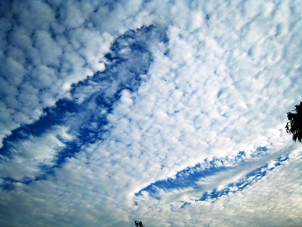
I’ve talked about distrails and hole punch clouds before, but I’ve actually never seen one myself until this morning, when I saw two side by side. It’s quite rare to have this kind of weather condition in Los Angeles. I took a couple of photos at around 7:30AM today, Aug 19th, 2007. Santa Monica ATIS reports the sky is clear now, but Van Nuys reports broken cloud at 18,000 feet and 28,000,which is probably where these are, given they look like they are precipitating ice in artificial cirrus uncinus. The cloud layer that the holes formed in is cirrocumulus.
[UPDATED Dec 2012]
There’s an excellent article on them at the Cloud Appreciation Society:
http://cloudappreciationsociety.org/fallstreak-holes-%E2%80%93-a-new-understanding/
We already knew that, for the hole to form, the droplets in the cloud layer need to be ‘supercooled’. This means that they are at a temperature below 0˚ Celsius, but have yet to frozen. In fact, cloud droplets can and do often remain liquid at temperatures well below the freezing temperature of a glass of water down here on the ground. When in the form of tiny droplets, water needs a nucleus of some sort to be encouraged to freeze – a tiny particle of some sort that it can get started on. Without one of these icing nuceli present, droplets will resolutely refuse to freeze until the air temperature drops to as low as –40˚ Celsius.
But what gets the freezing started in one region of the cloud? The research has confirmed the long-held suspicion that an aircraft flying through the cloud can be enough to set off the freezing process. The expansion of the air as it passes over the aircraft wings and (for certain types of plane) over the blades of its propellers, causes it to cool. This momentary cooling can be enough to take the temperature down low enough for the droplets to start to freeze spontaneously, even though there aren’t enough icing nuclei around for the droplets elsewhere to freeze.
The research also proposed a way by which the freezing water might cause a hole to expand outwards from the point where the plane flew through the cloud. When the droplets change into solid particles, they give off a tiny bit of heat – enough to cause the air to expand and rise a little. In reaction to this rising current, the surrounding air sinks slightly. As the air around the frozen fallstreak sinks and warms up, the droplets there evaporate. This seems to be the method by which the fallstreak of ice crystals produced by the plane climbing or descending through the cloud layer forms a circular hole that appears punched out of the cloud layer.
The larger ice crystals then drift downwards (as virga), since they are heavier, resulting in the characteristic “V” or “wing” cross-section of the central cirrus uncinus cloud, which looks a bit like a bird or an angel, if you are imaginative enough.
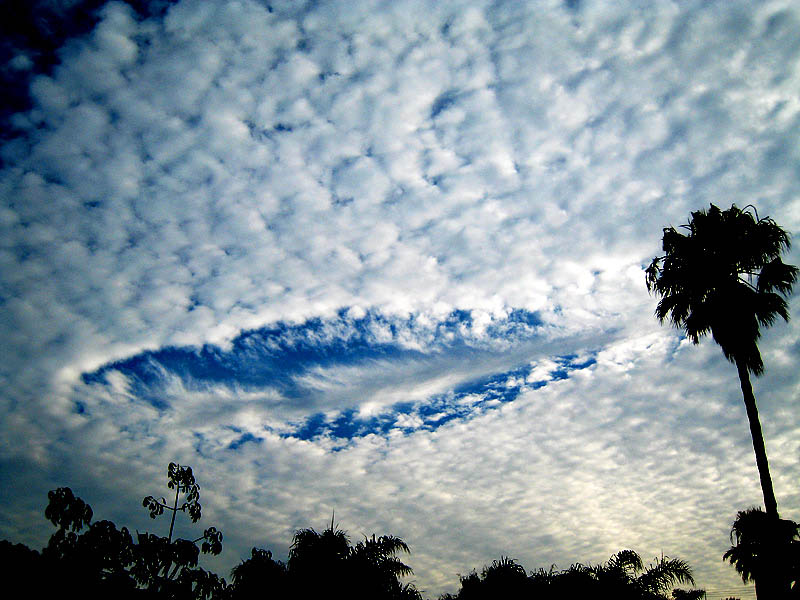
I like this second one, since it clearly shows the central contrail from the plane that made the hole (look by the palm tree). It’s not quite as nice a regular hole as some you see though. That’s probably to do with the location, being so close to the airport the climb/descent rate won’t be so steep at altitude.
(note, the above images have been contrast enhanced and sharpened, the original of the top one can be found here, for reference).
[UPDATE 2010/06] Here’s a paper that goes into great detail on the production of these holes:
http://journals.ametsoc.org/doi/abs/10.1175/2009BAMS2905.1
[Update 2011/01] Here’s a video that actually show the clouds forming.
[Update 2011/06] New paper/article on hole punch formation, suggesting that it cna lead to increased precipitation near airports:
http://www.sciencedaily.com/releases/2011/06/110630142847.htm
“It appears to be a rather widespread effect for aircraft to inadvertently cause some measureable amount of rain or snow as they fly through certain clouds,” Heymsfield says. “This is not necessarily enough precipitation to affect global climate, but it is noticeable around major airports in the midlatitudes.”
The researchers did not estimate the total amount of rain or snow that would result from such inadvertent cloud seeding. However, they analyzed radar readings that, in one case, indicated a snowfall rate of close to an inch an hour after several planes had passed through.
Contrail didnt do it. A dumped fuel trail did
How can you tell?
I don’t think these planes were coming into LAX, they were probably at 28,000 feet, heading for San Diego.
13 years ago i got my son a 400 dollar weather system,at the same time i got a book on clouds, a national geographic field study guide to be exact, i looked through all the books on clouds at the barnes and noble, all of them, i dont recall ever seeing or hearing about these hole punch clouds– jet fuel you say? i say this, commercial air traffic has been around for quite some time, and if jets or jet fuel dose cause this hole punch , then why hasent any body seen them until recent years? if a jet did dump fuel traveling at the speeds they travel, wouldnt it be elongated? some of the are, but the ones that are perfect circles just dont jive, i wonder if these clouds appear only us bases, dose anybody understand what HAARP is, jets? no———-something else? yeah—-but what?
mark, you should look up “fallstreak holes”, a more common name for the same thing. Try:
http://www.amazon.com/s/ref=nb_ss_gw?url=search-alias%3Daps&field-keywords=%22fallstreak+holes%22&x=0&y=0
http://books.google.com/books?q=%22fallstreak+holes%22&btnG=Search+Books
http://scholar.google.com/scholar?q=fallstreak+holes&hl=en&lr=&btnG=Search
While jet fuel dumping could conceivable cause fallstreak holes, I think most are just caused by either natural causes (precipitation from a higher level triggers the spreading hole, which then ends up circular), or from normal jet exhaust (giving the elongated holes).
Fallstreak holes were described back in 1963, in “A Color Guide to Clouds”
Personally i think the holes look like giant squid. but that is just me.
Yes they do, which reminds me:
Nice one Uncinus.
Excellent information and images.
I saw an almost perfectly circular punch-hole cloud above the airport in Bristol, UK, exactly where many of the jets steeply climb up after take off.
What I notice about chem-trail enthusiasts in general is that their text is often so sensationalised, almost screaming, but low on facts.
I could understand if governments had contemplated, or even tested, spraying compounds into the sky (like cloud seeding using silver iodide or dry ice), perhaps to see if a mass-innoculation could be achieved against something or other, but it’s a rather obvious way for us to be constantly ‘medicated’?.
Most chemtrail enthusiasts believe that the purpose of contrails is something other than drugging the population. They think that chemtrails have some secret military purpose (such as long range radio communication via atmospheric ducting) or are for geo-engineering type weather modification. They do think the chemtrails are toxic, and believe that this is the reason for the huge cover-up.
There is a minority that thinks that they are for population culling, or other esoteric purposes. I’d say also that many people simple say that “something” is going on, and support several theories simultaneously.
Can you say: DIS-INFO! This is pathetic.
Does “UFO” ring a bell? Or “cloaking”?
Mr. Donut, it rings all kinds of bells, but so did lepers. Lepers were kept cloaked, as well. So avoid any theory that calls for either.
When there is proof of either, come back and we’ll talk. Until then, a fallstreak holes and the resulting plume underneath sometimes, have a valid, proven, reasonable explanation based on known scientific principles. Which means they are fallstreak holes. Occam’s razor applies.
Anonymous, Mr Donut: definitions for you
“Misinformation” : “chemtrails”, “tic-tac-toe”, “grids”, anything written or spoken by chemtards.
“”Disinformation” : description given to accurate information as imparted in science class by chemtards.
“”UFO” : unidentified flying objects, 99.999% of which are polythene bags. 100% of these flying polythene bags are identified as UFOs by <emchemtards.
“”Cloaking” : Romulan Warbirds are the deadliest of spaceships because they can “cloak” themselves and thus creep up on the United Federation of Planets’ ships without being seen.
Fortunately, they cannot fire their weapons without first de-cloaking, which is their downfall, for Captain Kirk’s (or Picard’s) Enterprise ALWAYS gets the drop on them thereafter.
It’s also what the Chinese and Japanese say that frogs do…
Meterology isn’t science it’s a fraud as is Uncinus, there is no science to be found on this website. Uncinus uses the same specious reasoning as those he criticizes. Where is your data? This guy has data http://www.carnicom.com/. This might be bad data but it’s data nevertheless. Quoting other sources doesn’t prove a damn thing. Anyone who works in a scientific field on this earth knows that data which is presented has been altered and skewed to obfuscate and serve agendas. Weather modification is real, so is HAARP, only delusional morons like Uncinus would believe otherwise.
Uncinus I urge you to pick any day when these so called “Chemtrails” cover the sky to go outside and undertake vigorous physical exercise. By all means breath deeply. I recommend that you do this often and when you start to hack up junk don’t let this deter you continue and increase your effort. Remember there’s nothing to see here it’s all in your imagination!! I’m sure that you’ll enjoy the health benefits. It does wonders for you circulatory system and brain!
Meterology isn’t science it’s a fraud – You may be right… but Meteorology is an established science more than three hundred years old with its own publications, society, scholarship and history. Hard-working, intelligent and professional people work in it. Vast resources are dedicated to it, satellites are launched to study it, and supercomputers are built to simulate it.
there is no science to be found on this website – There’s none so blind as those who don’t wish to see.
Uncinus uses the same specious reasoning as those he criticizes – Not in my experience he doesn’t. He tends to use plain common-or-garden reasoning and leave the speciousness to – people like yourself.
This guy has data http://www.carnicom.com/. This might be bad data but it’s data nevertheless – Well, dammit, I went and checked and surprise! – he’s changed his ghastly format (someone must have whispered in his ear) but not his delivery. I couldn’t find a single verifiable fact. Perhaps you could tell me where they were hidden?
Quoting other sources doesn’t prove a damn thing – Well, actually it does. You see, science papers are published in respectable journals, and are studied, tested, and challenged by other respectable scientists. Once they have passed that hurdle they become part of established science. They may, of course, fail at some future time when new evidence comes to light.
Anyone who works in a scientific field on this earth knows that data which is presented has been altered and skewed to obfuscate and serve agendas – Personally I always knew that monkeys would never type the works of Shakespeare – not even in an infinity of time…. You obviously haven’t worked in a scientific field. A scientist’s reputation rests on his work, and is reinforced when a scientist in some other part of the world corroborates or duplicates his findings.
Remember there’s nothing to see here it’s all in your imagination – Your recollection (an asset to a scientific mind) is too poor to fit you within any scientific endeavor, as here it is too poor to recollect what we have said about persistent contrails.
Pindar-
Atmospheric science is Science. This is a field separate from Meteorology…it is the study of the physics of the atmosphere. It is where you need to start if you want to know about the trail you see in the sky.
There are 100s of peer-reviewed, scientific papers, written by atmospheric scientists from around the World, written over the last 50 years that clearly elucidate the physics of jet exhaust and the ambient atmosphere….all with a ton of data-
…a simple review of the accumulated data over the last half century might put your fears to rest.
I encourage you to research the term “contrail cirrus”
or even: “supersaturated persistent contrail”
Will you?
Why not?
Weather modification does indeed take place. That has never been the issue. Cloud seeding has been done for decades, hail mitigation, hurricane mitigation etc…are all being studied and tested…
…that is in no way proof, evidence or in any way conclusively related to the idea that every persistent trail one sees in the sky is really the result of a global, clandestine, “spray” campaign of unknown origin and unknown purpose…
…”only delusional morons…would believe otherwise. ”
Also- this is classic- you refer to Carny-com and his “bad data” and then follow it up with this comment:
“Anyone who works in a scientific field on this earth knows that data which is presented has been altered and skewed to obfuscate and serve agendas”
Carny-com included, right?
But that is the beauty of peer-reviewed, testable science…one person may publish BS but there will be a lot of others who will do the work themselves to verify and call BS when they see it. 50 years of accumulated data, tested and rested by scientists with a wide range of agendas, backgrounds and origins carries much more weight than Carny-com’s “bad data”. Do not fool yourself.
As someone who lives in area that is supposedly a “heavy spray” zone and who spends a lot of time outside and undertakes vigorous physical exercise- even on days with lots of trails…I have never experienced ANY respiratory effects…ever.
No one I know has…ever.
Attributing current physiological conditions to the contrails over your head is highly illogical, completely unsupported by science of fall rates and dispersal of particulate matter in the troposphere, is not supported by any known medical corollary …and borders on ludicrous.
but whatever.
…sorry…previous post was me….SR1419….
these are chemclouds-clouds of chemicals youtube.com/leharra i am a chemcloud activist
leharra, please provide a single shred of evidence to support your claim. Your lack of knowledge about clouds is so very evident.
Leharra:
How tragic.
If you were to study science you’d soon find yourself short of a career.
I’ll hope for that, for the alternative for you is going to be much, much worse…
Jazzrock,
If you get a moment, watch the video by leharra entitled “what do chemtrails & h.a.a.r.p do ? let me tellya”. This woman actually thinks that “they” are re-writing meteorology books to include clouds “with fancy names” so that us sheep will be fooled into thinking these clouds have been around for a long time. She actually says that since they have been testing harp on Hawaii, there have been earthquakes and that there hadn’t been any for “a couple a hundred years” before that. Can you imagine? She lives on a volcanic island, but thinks earthquakes are a new phenomenon there. Pathetic.
Shill, I had already seen this and come to the same conclusions that you had arrived at. All of them!
This lady has bought the works, hook, line, and sinker… and is quite likely irrecoverable.
I too live on a volcanic island – smaller, I know – but producing the same weather features as Hawaii. The finest feature common to both is (on occasion) a massive overtopping lenticular cloud, sometimes with downwind wave lenticular “echoes”.
Being a volcano (actually there are 84 vents) there is always some seismic activity. One of these vents is due to “pop”, as magmatic outflows here are approximately hundred years apart and it’s been a hundred years… 🙂
“This lady has bought the works, hook, line, and sinker… and is quite likely irrecoverable.”
Aint that the truth….
I watched the video and I couldn’t stop shaking my head. The fact that these people think we are “sheep” simply for understanding the facts of science, is too disturbing for words. Imagine living life like that?!? I shudder just thinking about it.
I saw two of these in Lake Worth, Florida. If this was caused by a plane that would explain a lot. They definitely looked very odd.
Not that anything of a ufo nature had anything to do with this, but JazzRoc shouldn’t be passing off that topic, if that is what he was doing. It is a very real phenomenon that has been documented for thousands of years. The fact that there hasn’t been any “official” releases of information doesn’t mean that the phenomenon doesn’t exist. France and England are disclosing a lot of their recorded case files.
Lots of UFOs, sure, the “UFO” phenomenon exists. But what does that tell you? That not every object seen in the sky has been identified.
Contrails also exist, and some people can’t tell what they are.
So, the contrail you speak of here is more likely the water particles that are dropping from the hole. I don’t buy planes being the cause when most of these rare formations are circular. consider other options?
The planes simply (sometimes) trigger these interesting formations. They naturally take on the circular or cigar shaped appearance, irregardless of what triggered them.
Linden :
They tend to be circular because they are the result of INSTABILITY in the surrounding stratosphere.
In the case of “distrails” or “fallstreak clouds” some point in the the thin saturated air – just some single point – will “trade off” energy to deposit MORE ice on a very small (relatively) number of ice crystals. The reduction in temperature required reduces the average velocity of the air molecules and so the surrounding air becomes DENSER. This denser air falls through its lighter surroundings. The increased movements offers further opportunities to deposit even more ice onto the falling crystals. The faster these crystals fall through their surrounding air, the heavier they will get. The heavier they get the faster they fall.
It’s definitely a classic instability. Before it begins there seems hardly a chance to begin it. Once it begins, there is hardly a chance to stop it.
SO in the centre of these “distrails” (made by airplanes) or “fallstreaks” (naturally-occurring) you have rapidly-falling columns of ice crystals.
These may occur lower down by slightly-different sources, where they are known as “sylphs”.
However they occur, they are made of natural fresh water ice, and their fate, inevitably, is to evaporate back into air. It’s the fate of most airborne water to constantly repeat such cycles.
Hi..Hope I’m not becoming too prevalent a fixture around here; I guess I’m attracted to this sort of stuff.
I wanted to post a comment on these hole punch clouds. Uncinus, the explanation you gave for the holes in the clouds is very logical. I do wonder why some of these holes are round. That’s not to say they’re made by HAARP or something however.
On that note I have heard that some people believe these clouds are caused by experiments involving directing high energy ion or particle beams into the atmosphere.
I’m a long time science and science fiction buff and as such I have a fascination with the concept of energy weapons. I studied lasers in college for a while and I can tell you that lasers do NOT make good weapons in real life. Neither do ions, particle beams, or plasma. The reason plasma doesn’t make a good weapon is largely related to the fact it cools rapidly. As for the lasers, ions and particles (I.E protons, neutrons, etc) the reason is largely scale and power consumption issues.
The ABL (air born laser) being tested by the airforce, right out in the open, in the ‘white’ as they say has been out there for some time in plain view. It’s a chemical laser (COIL, or Chemical Oxygen Iodine Laser) which can indeed shoot down missiles or small aircraft. It is also so big it HAS to be in the body of a jumbo cargo plane. The main part of the laser consists of five modules the size of refrigerators. It requires several tanks of chemicals to be hauled along with it for lasing. With particle beams and ions the problems are very similar. All these devices are extremely inefficient. You get very little ‘bang for your buck’ so to speak. Hardly anything you put in in terms of electrical, optical or chemical energy comes out as laser or ion emission, etc. That’s entropy; a well known scientific law.
Now in the case that it’s been said that the government or military is blasting clouds with ion beams you must keep in mind that while there ARE accelerators capable of firing linear beams of particles at high energies (LinAcs as they’re called, or Linear Accelerators) they tend to be huge and not very portable. Also the bigger they get the less efficient they become and you need even MORE power to make them run, and unlike a laser beam which can be directed or ‘steered’ via the use of optics like mirrors and prisms, particle beams need to be steered by the use of powerful magnetic fields. Again, not easy to set up.
Now back in the nineties there was a project designed at building a plasma cannon at Los Alamos at which they did indeed design a device which fired weapons grade ‘donuts’ of extremely hot plasma-which propagated all of a few meters before they cooled and dispersed. The project was allegedly shelfed or entirely dismantled because it wasn’t getting results.
Now, I’ve heard the arguments that Well in that particular interest they only TOLD people it was dismantled because they actually LIKED what they were seeing and didn’t want it to become common knowledge that we had a plasma gun in the works.’
I’ve also heard the beliefs that society has generally been fooled, and that the true level of science in the world and of technical achievement is actually far in excess of what the population is led to believe. I tend to take a somewhat dim view of that train of thought; That’s not to say that it probably isn’t at least partially true in some areas of science. But I rather doubt that the world’s elite are actually taking antigravity luxury carts to Mars for vacations under our noses. I don’t really believe in back engineered alien weaponry.
Why? Well, simple. Imagine taking the SR 71 back in time to the court of King Richard the Lionheart and asking one of his subjects to explain what it was and how it worked. It is highly unlikely that they could come up with anything other than that it was designed to fly, given its vague and general resemblance to a bird. They could not have known anything about the principles of aerodynamics, avionics, stealth technology, composites, electromagnetics or any of the other host of technologies that make it work.
To suppose that we could take a piece of alien technology that could be hundreds of thousands or millions of years ahead of us and understand it in fifty years is similarly unbelievable and more, by orders of magnitude. That’s not to say I don’t believe in UFOs, I’ve seen a number of them in fact. I simply don’t believe we could understand how something like that functions, in generally what amounts to over night.
So, is it possible that some areas of science are more advanced than what we generally believe? It’s possible.
Is it possible that, the government or the military would want to experiment with powered directed energy weapons? There is no doubt of that. There are many instances of this right out in the open such as HELADS and Nautilus.
Is it possible that the government or elements within it are corrupt, self-serving and do not wish to have found out what their true motives are? Again, I have no doubt of that. The old adage, ‘Absolute power, corrupts absolutely,’ is still quite true as is the saying ‘Thieves in the night shun the light.’
So does that mean the government is ‘out to get us’? Or that they have super secret plasma, tectonic, ultrasonic and psychotronic weapons?
Well, that I can’t answer. But it is a pretty strange world.
Why are they round? Simple – they start out as small holes, and then grow outwards at a constant speed. So they naturally take a round shape around the original seed. If the seed is a contrail, then they get these long shapes. If it’s just a small amount of local precipitation, then they end up round.
Added a couple of videos to the post above. Hole punch clouds forming.
Someone mentioned they look like Giant Squid.
As a Pastafarian, I believe this is proof positive of the Flying Spaghetti Monster (may his balls ever be saucy)!
I would say that to be a true Pastafarian you should not need any actual proof of His existence. Like many modern western religions it should be by faith only that you are a true believer.
Maybe so – but “should” is only a moral imperitive subject to the whims of the person concerned.
I’m pretty sure all religons would love to have proof positive for the existence of their creator or diety or holy work or whatever…..so Dionys is just paralleling “modern western religons” in his expression of hope.
Honest 🙂
So you would contend that the modern dogma of belief in the absence of proof only exists because of the lack of proof. Therefore, if proof did, in fact, exist this precept would not be neccassary.
Further, those who have not experienced what could be considered positive proof can choose to hold that precept and those who have experienced proof don’t need to hold it anymore due to the existence of proof. It actually works quite well.
“I don’t need proof- I have faith and faith is more valuable in my religion than proof”
or
“My faith is reinforced by my observance of proof”
I’m not sure how this relates to chemtrails but after a while I’ll circle back around to that.
I don’t think Douglas Adam’s method for getting rid of God woudl actually work, if that is what you mean! 🙂
Great story on NPR tonight regarding the effects of local air traffic on weather. Super cooled water and snow creation and other things. Also some talk of hole punch clouds. I don’t remember the name of the group but a rep was interviewed and it seems there’s a group out there more into cloud sightings and aircraft than us.
It probably was related to the publication “Formation and Spread of Aircraft-Induced Holes in Clouds” in the today’s issue of Science:
http://www.sciencemag.org/content/333/6038/77
http://www.sciencedaily.com/releases/2011/06/110630142847.htm
Thanks Steve, I’ve added that to the top post.
I’m living right in the Frankfurt approach zone – so they are making extra rain or sleet for me ?? Where can I file my complaint ?? Whom can I sue ??
Uhm, wait, we didn’t have enough rain this spring … maybe there is even a reason to be thankful ?
There you have it – again. Reality is bloody complex.
Methinks I should have read that article more thoroughfully. Especially those bits with the percentage and the significance.