One very popular photo amongst the “chemtrail” theorists is this one from NASA:

This enhanced infrared image from NASA’s Terra satellite shows a widespread outbreak of contrails over the southeastern United States during the morning of January 29, 2004. Satellite data are critical for studying the effects of contrails. The crisscrossing white lines are contrails that form from planes flying in different directions at different altitudes. Each contrail spreads and moves with the wind. Contrails often form over large areas during winter and spring. CREDIT: NASA
The image is quite striking, showing a very large number of contrails over an area five hundred miles wide. It’s an infrared image which has been enhanced specifically to bring out the contrails. This image has been used by NASA a few times:
http://www.nasa.gov/centers/langley/news/releases/2004/04-140.html
http://earthobservatory.nasa.gov/IOTD/view.php?id=4435
http://mynasadata.larc.nasa.gov/lesson-plans/?page_id=474?&passid=83
It’s actually a small part of a much larger image. It was cropped and enhanced to just show the areas of contrail activity. Here’s the full image:

The full infrared image
You can already start to see that the contrails are confined to a band of cloud, they stop abruptly where the clouds also stop. It’s a bit less dramatic in the original infra-red image. You get an even better view of the overall situation in the true-color satellite photo:

True Color Satellite Image. Note these are all from the same photo.
Looks a lot less dramatic now. But still, it’s an unusually large amount of persistent contrails. Something you only get with some rather specific weather conditions. Of course, you get conditions like this every day, somewhere in the US. It’s just unusual to have such a wide area.
The above image is available at full 250m/pixel resolution. It’s a 17MB jpg file, here. Quite a spectacular image, with some dramatic “grids” when you zoom in.

Full resolution image of contrails over Florida. Look at the direction they are streaking in to see the wind direction
We can tell which way the wind is blowing for a particular cloud by seeing what streaks it leaves behind. This is particularly true for ice clouds – as the older crystals grow large enough they precipitate out and sink to air that is generally slower moving (wind speeds generally increase at you get higher, and decrease as you get lower). This is also what produces the distinctive Cirrus Uncinus clouds, which are basically the same thing, except they are from smaller individual clouds, not a long thin cloud.

From the 1963 book “A Colour Guide to Clouds”, this diagram shows how decreasing wind speeds cause precipitation from an ice cloud to spread out as it falls.
We can see this pattern of wind pretty consistently when we look at the weather aloft for Jacksonville Florida. This is from Jan 30th, 2011, so at the same time of year.

Winds aloft over Florida. This shows that contrails will be blown to the east at 100 mph, and as they precipitate ice it will be spread over the sky.
If you look at the contrails just to the upper left of the center, you can see the streaks point more or less a bit south of west. So we’ve got a westerly wind blowing. The contrails are moving, probably pretty fast (over 100 mph) towards the East, and out into the Atlantic. We can see this even clearer if we enhance the contrast on those contrails over the ocean:

You can see how far the contrails have moved. Probably twice as far as the length of the tail they leave.
The lake in the bottom left is Lake George in Florida. It’s about ten miles long. We can see that some of the older contrail tails are around 30 miles long and that the contrails to the East have longer tails. All of this suggests that the contrails were formed a long way from where they ended up, possibly more than 100 miles away. If a contrail were to persist today for two hours, then with the 122 mph winds at 34,000 feet, it would move 244 miles away from where the plane originally flew.
With all this information is very easy to see how the grid patterns form. Planes flying either over Florida to other destination, or flying to and from the cites of Southern Florida, will leave trails in this large mass of moist cold air. These trails will successively be blown to the east at 122mph, leaving the long smears of clouds across the sky, while new planes fly along similar routes, leaving trails parallel to the firs trails. These continue to be blown to the east, and after a couple of hours of the right weather conditions, and perfectly normal air traffic, we get the impressive looking images we see above.
Unfortunately, in the chemtrail community, this impressive and informative image has taken on a life of its own, co-opted to suggest the pattern of spraying is deliberate. Here’s an example of the reasoning given:

The “chemtrail” interpretation of the image. Note that “lines connecting cities” is the exact opposite of what we would expect to see.
They indicate the positions of some nearby cities and say that because the lines don’t connect the cities, then it must be a deliberate grid. Of course “lines connecting cities” is the LAST thing we would expect to see in a satellite photo of contrails. Firstly, as we see above, the contrails are moving east at 100 mph, so they will not end up positioned on the line between the cities, but instead tens or hundreds of miles away, but parallel to that route.
I wrote a simulator to demonstrate this:
https://contrailscience.com/contrail-simulations/
And this video illustrates it perfectly
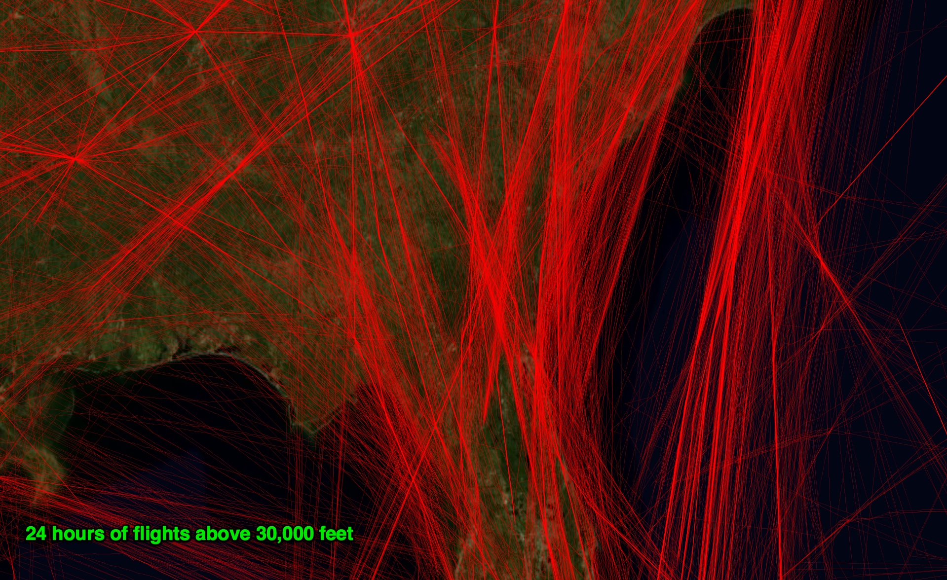
Secondly, and this is a frequently missed point. Planes don’t leave contrails near the airports they land at or take off from. They don’t because they are too low. Only when a plane reaches cruising altitude will it typically be cold enough for persistent contrails to form. If a contrail is seen near an airport, then it’s flyover traffic. Quite often though airports are used as navigation beacons, so act as a kind of crossroads in the sky. So while you will see flight paths above 30,00 feet radiate out from those cities, they are not actually going to those cities. Here’s a plot of FAA data of all flights above 30,000 feet for one 24 hour period in that region:
Thirdly, as you can see from the larger images, the regions of moist cold air are concentrated in bands. It’s actually quite rare for a contrail to form and persist for the entire length of a flight (at cruising altitude). You are going to see the contrails broken up, and only in some areas, as the plane moves in and out of various regions of the air.
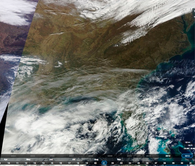
So, an impressive image. But what it’s really indicative of is the weather conditions on that day, and the sheer volume of traffic we can get in a few hours over that region of the US. Check out this video to see 24 hours of flights:
This intensity of contrail cover is actually fairly rare. I reviewed all the shots of that area for winter 2012/2013, and I only found one that looked similar. Jan 21, 2013.
Shakira,
I for my part can only agree to what you are saying about intentions in this discussion. Unfortunately, on both sides there are human beings, some more hot-blooded than others.
For a good exchange without self-rightousness, we should concentrate on the issues and the facts, ignoring occasional ricochets …
Hey Shakira, that sounds like a reasonable plea. Especially this –
“If there isn’t – then we DON’T scream at the chemtrail-believers, telling them they brought everyone out for nothing, and make them feel worse or less. We shake hands and try to explain our observations.
… But I really belive that, whoever is right, we should not do this simply to ‘be right’. We should do this either to ‘calm down the chemtrail-believers and reassure them/us with scientifically-proven remarks…’”
This whole site is the very embodiment of that last sentence. Are you implying that this ISNT happening, and believers are being screamed at or made to feel stupid for just having a very basic human concern about something that is a worrying possibility, that then doesn’t happen to survive in the face of verifiable facts?
Are you sure just aren’t projecting an expectation of how you would act or feel if you were on either side of the proven evidence?
I know there are exceptions in the comments, usually following a rant from a believer who illogically and despite the clear evidence being presented in a clear calm manner, accuses this site of being a disinfo psuedo-science government plot. At which point I think a person is fully justified in saying to that person ‘you’re an idiot, and you are causing pain and confusion unnecessarily or even malevolently and that is WRONG’.
But just having a concern that this might be happening, and if it is that’s terrible, is not wrong, it is the correct position for anyone to take, and NO-ONE has ever said any different.
What is NOT the correct position to take is to persist in the belief it is still happening when, like in your comment, the conditions are met for providing ‘scientifically proven remarks’, that the evidence as used by believers, is explainable as normal phenomena – where it’s not just misrepresented, incompetently gathered and interpreted, or outright fraudulent by the originators of the hoax.
No-one here seems to then take the position of going “Haha I was right and you were wrong so you’re an idiot!” I see no evidence of this, only concern and compassion for those who very rightly are worried about the possibility of nefarious goings on. This concern for actual truth and how it might help people’s peace of mind has resulted in the scientifically or investigatively verifiable data you can see and confirm for yourself here.
And yes, totally, if you can find evidence that is not explainable to those here at this website, definitely get it out there and inform people. But make sure it’s correct before you do, or you are doing mankind a massive disservice. If it’s true however, yes, you would be a hero.
Everyone wants to be a hero.
The snow on Mt. Shasta has been tested many times and is said to contain toxic levels of aluminum and barium. People in N. Arizona who have filed a lawsuit regarding chemtrails claim to have documented medical tests showing toxic levels of aluminum and barium IN THEIR BODIES.
How can this be?
They are mistaken. The tests showed normal levels, and they misinterpreted them. The snow they tested was pretty dirty. See lots of detail here:
http://metabunk.org/threads/137-Shasta-Snow-and-Water-Aluminum-Tests
The Arizona people are also wrong, their tests didn’t show anything toxic, only ordinary levels of barium, which is mainly obtained from ordinary foods which contain barium. Their County Health Department spent a good deal of time explaining all of this in a public meeting. You can read al about what happened here:
http://metabunk.org/threads/128-High-barium-levels-in-blood-(-Mohave-AZ-)
This is purely an attempt at debunking. This person decided to set out to try and do that and… tried to, but fails.
Geo-engineering is real. There are patents dating back decades ago; patents which specifically state aerosol dispersion and solvents containing metal oxides.
Here is the deal for anyone else that comes by to read this slant put forth here: Bill Gates funnels money into this things that doesn’t exist (research it). Yes, you got it right, Gates likes to throw his money behind a fictional myth or fictional conspiracy. Also, look up David Keith.
I agree it is purely an attempt at debunking. There’s a lot of bunk, and I point out what the bunk is. What’s wrong with debunking?
Geoengineering is theoretical – there are no deployed projects.
Yes, look up David Keith. But don’t just look up the out-of-context quotes that the chemtrail promoters use. Look at what he actually says. He’s AGAINST spraying, and says there’s no evidence that any spraying is going on. He also says that we need to proceed with extreme caution.
water vapor from planes? give me a break, they don’t leave streaks in the sky you can see from the ground and from the air and from space. come off it. total disinfo.
It’s called contrails, duh.
Im not denying the fact that contrails could very well be perceived as chemtrails and vice versa… but chemtrails themselves are very real. Hughes Aircraft Patent #5,004,186. The evidence is out there.
Type error on my above post. Its patent #5,003,168.
Some funny stuff here, imho.
So when we do manage to get a clear sunny day out, and we see the odd contrail, that actually does disipate, and the sky is a nice clear blue sky like the old days, I guess you will say, it’s a slow day for airline traffic or some such nonsense.
Just because you show a couple of “photos” from 1967, and whenever, doesn’t mean a thing seeing as they’ve even photoshopped chemtrail and x’s even into old movies now.
Lord some people are so naive as to believe you debunking sites, that are just more cointelpro shill sites throwing more confusion into the conspiracy soups of sites and disinfo out there.
Oh well, you can fool many people all of the time, but there are a few of us out there that don’t buy any of your peoples BS. And I’m sure as usual, this post won’t be allowed either. That’s your mo’s.
Ivehearditallnow, I think you need to read some more of the articles on this site. Your first point is addressed here. No, it’s not a slow day for air traffic.
No one is here to sell any “bs” to anyone.
If you don’t like the information here, please provide evidence to refute it.
i hope my wife sees this site. i am not sure if she really and truly brlieves all that crap but she talks about it a lot.
http://www.weathermodification.com/projects.php What is this then and this http://www.evergreenaviation.com/supertanker/mkts.html They both state “weather modification”. I am new to this as someone mentioned it in passing and I looked into it… Are the people claiming “chemtrails” referring to this or is it something else all together?
Me,
Lacking any evidence that the contrails people see are something other than ordinary commercial planes, the promoters of the chemtrail conspiracy theory have conflated it to include baseless speculation that they are seeing “weather modification”. The same promoters do not tell you the following facts:
Weather modification only seeks to modify weather by influencing clouds to rain or snow or to prevent hail damage. This takes place within weather systems far below the altitudes that contrails form, and is regulated by state permitting agencies in an open manner with public comments and strict scientific oversight and record keeping. Weather modification is not a secret, and it leaves no trails like people are calling “chemtrails”.
Uncinus, Nasa has admitted that these “Contrails” are now altering our global climate and compose up to 40 % of the global yearly cloud cover ??? There was also talk of a “scenario” that could be used in the future to combat climate change; at the Davos conference a few weeks ago. This scenario involves using high altitude planes to release sulfates into the upper atmosphere to reflect sunlight and cool the planet. Is this not the exact same thing as chemtrails ??? You are saying they are Contrails but they are doing the same damage as what others call Chemtrails?? Tomatoes – Tamatoes??? Either way these man made trails are completely effecting our planet and something needs to be done to stop it ASAP.. Do you not agree ????Also the Weatherchannel is having a special this Sunday called Hacking the Planet & its all about weather modification ????
No- any effect caused by the current persistent contrails are incidental. Meaning that there is absolutely no intention to create them. Chemtrails implies intent.
If you really want to get down to it, preventing the current persistent contrails would mean intentionally placing aircraft at altitudes that require higher fuel consumption and would therefore place more particulate matter in the form of exhaust in the atmosphere.
Ivehearditallnow, could you maybe provide some evidence of the addition of trails to old movies IE link to a clip showing the film before the addition and a clip after the addition please.
Trhuth seeker – do you have a link for that 40% cloud cover claim?? It seems very high so I would like to see the evidence behind it.
Jay wrote;
“Weather modification only seeks to modify weather by influencing clouds to rain or snow or to prevent hail damage. This takes place within weather systems far below the altitudes that contrails form, and is regulated by state permitting agencies in an open manner with public comments and strict scientific oversight and record keeping. Weather modification is not a secret, and it leaves no trails like people are calling “chemtrails”.
What do you base your claim on ? How versed are you in plasma physics and electric properties of nano metal composites? Have you studied this subject?
I will be providing you many examples ( documents and testing ) that do not agree with your claim over at metabunk soon.
-Bryan
The Spirit of Truth, Whom the world cannot receive (welcome, take to its heart), because it does not see Him or know and recognize Him. But you know and recognize Him, for He lives with you [constantly] and will be in you. John 14: 17
bryansail said:
“How versed are you in plasma physics and electric properties of nano metal composites? Have you studied this subject?”
Cloud seeding works through well known principles. From Wikipedia:
“The crystalline structure of β-AgI is similar to that of ice, allowing it to induce freezing by the process known as heterogeneous nucleation.” That’s why mostly silver iodide is used for cloud seeding, but Russia is known to empty cement bags onto clouds to guarantee fair weather for May parades.
Not exactly nano technology.
No, not cloud seeding.
Nano tech has diverse aerosol applications. I think CARE has been mentioned here previously, but that is just the tip of the iceberg.
So what are those applications? how about being actually specific rather than throwing out broad claims.
the discussion WAS about cloud seeding – now you seem to be wanting to change it.
Hi Mike,
Time permitting I will be posting specifics over at metabunk. Looks like that will be about a week and a half. I am not in agreement with almost everything that chemtrail believers state, but believe that atmospheric tinkering is much more sophisticated than the current paradigm believes.
The basic rule in disinformation is that around 95% of the exercise be true, so as to sell the 5% “nugget” of disinformation. This relies on peoples’ use of consistency as a measure of truth.
Contrail science is 95% correct, but the 5% where this site is wrong is what propels the interest to continue.
Well, I’m aiming for 100%, so let me know what needs fixing.
I have notice an increase since just after 9/11.. But I drive for a living and see so many more in the sky now .. I am on the fence I wonder what is this.. I googled it and now I am more lost. Half the info is chemtrail and half is contrail..where does that leave me hoping our government wouldn’t hurt my kids and all of us. And still wondering what’s really going on. I don’t think it’s fair to call people nuts for questioning things that seem strange. Many things that the government and people have done over the years were harmful and not well thought out or just to make money so it is not exactly unheard of. I would like the truth but where is that who do we believe when we are just the little people hard workers and really depending on others that have the power.. The truth would be nice..I hate that we see a beautiful blue sky then after watching these contrails for an hour the haze takes it away kind of sad even if its not poisonous.. would love to believe it’s harmless
There’s about five or six pilots here that post regularly. Would you accept an explaination from a pilot?
True, it’s not fair calling people nuts for asking questions. But if they discard any answers given, are married to answers without any evidence etc., well, they are fairly nuts.