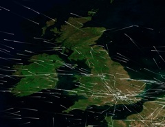
I took these photos around 8AM this morning, Feb 4th 2009, in Los Angeles.


They show Cirrus Uncinus clouds, with a contrail running through them.
Cirrus uncinus clouds (or “Mares’ Tails”), according to wikipedia:
Cirrus uncinus is a type of cirrus cloud. The name cirrus uncinus is derived from Latin, meaning “curly hooks”. Also known as mares’ tails, these clouds are generally sparse in the sky, and very thin.
The clouds occur at very high altitudes, at a temperature of about minus 40-50 degrees Celsius. They are generally seen when a warm or occluded front is approaching. They are very high in the troposphere, and generally mean that precipitation, usually rain, is approaching.
And indeed, looking at the forcast, rain is coming, predicted for tomorrow and the next three days.
The long “tails” of the cirrus uncinus clouds are actually precipitation – very high snow in the form of tiny ice crystals falling through the air. The wind blows these sideways, giving the distinctive hook shape.
The contrail in the same region is persisting for the same reason the clouds persist – it’s in a region of the atmosphere where there is moisture. Notice the abrupt end of both the the contrail and the clouds at the left of the second photo. Contrails are a form of cirrus cloud, and if there is enough moisture in the air, a contrail will eventually spread to be indistingushable from the surrounding cirrus. In this case though, the cirrus uncinus would have been exactly the same even if there were no contrails.
Perhaps I can give some more information on this type of cloud.
A lot of people see cirrus uncinus as “creatures cleaning up chemtrails”. They call these “sylphs”.
Cirrus uncinus is an indication of an unstable layer in the atmosphere. The hooks have an upcurrent of around 7 cm/s, the tails have a downcurrent of more than 50 cm/s. It is this downcurrent that limits the life of a contrail, making it look like “sylphs clean up chemtrails”.
Hey! Great site. If I loved clouds and this stuff as much as you did, I would probably be depressed from being reminded that I’m not traveling as much as I could be : /
Excellent pictures of chemtrails, exactly like those I saw today, Easter Sunday, where I live.
And another thing I saw: I watched some planes making them.
After they were laid down they spread out, and finally the whole sky looked foggy. Fake fog.
http://www.cfr.org/project/1364/geoengineering.html
Wonder when you will put your site to rest or maybe just build up a gallery in a style of some fake fact based museum on what clouds once looked like, ah, well as always the government and their CFR finally get around to admitting they are doing this, they like to piss around for years before they talk about dong something that has been done for some time. Even teller is mentioned in these CFR documents, and how aerosols can be sprayed with very cost affective means. Less than 100mn is the ballpark figure.
Of course all this is old news to ones that are willing to accept reality and now what they percieve to be rality based on opinions instead of facts from government sources, don’t forget those documents from governments across the world that are now declassified in some part and available for all to read on how the government has conducted weather modification experiements dating back to the 1940s.
I won’t be here to read any replies or any written up articles in reply to this, or even bother to look for any if they already exist on this site. Waste of my energy, I only came here to post the cfr URL.
I think you confuse thinking about something with actually doing it.
Sure, there is lots of evidence that scientists all over the world have thought about geoengineering and global scale weather modification. They have been thinking about it for decades. It’s not ever been a secret, lots of papers have been published, lots of suggestions have been made.
But what evidence is there that they are actually doing it?
Persistent contrails?
But truly Uncinus – who the ‘f’ are you to say that YOU KNOW that ‘they’ are only thinking about it – what front are you trying to sell?
Are you sponsored by a subsidiary of the company that has already aqcuired the government contracts to do this type of geoengineering contract work?
“lies are carefully crafted to give their creators an advantage..bullets are carefully crafted to bury the guilty” ….anonymous
“your mom”, I’ve no idea what “they” are thinking about, or doing. What I’m going by here is the actual evidence. The point is that there is NO EVIDENCE that contrails are substantially any different now than they ever were (except for there being more of them).
If you think otherwise, then why not state your evidence?
Because their evidence consists of:
“I don’t remember contrails act like that when I was young.”
“Look at the videos on youtube!”
“How can Millions of people be wrong.”
“I know what I have observed and what I believe.”
and so on and so on
There is no solid evidence of chemtrails, none, and that’s what drives the movement, the unknown. As far as I’m concerned, chemtrails fall into the same category as UFO’s, Big Foot, Nessie, Astrology, Tarot Readings etc…lots of belief and hysteria; but, not one shred of solid, verifiable evidence.
I’m afraid that Uncinus is correct. I studied the theory of chemtrails and believed that they existed because of a few persistant spreading contrails that I thought were formed in low humidity environments.
When I looked at it from another angle I got some clarity. When the upper levels of the atmosphere are conducive to the formation of persistant spreading contrails, people report chemtrails in the cooresponding cities. When the atmospheric conditions are not conducive for this type of contrail the chemtrail crowd is silent.
See for yourself. Find the cities with the highest upper levels of humidity and you’ll be able to predict the so called chemtrail hot spots.
Most chemtrail conspiracy followeres report the most chemtrails prior to a storm. This is precisely the type of environment needed for the formation of persistant contrails.
Vance, that’s very true. I Live in Los Angeles, and in the summer we get very few persistent contrails – sometimes I won’t notice any for a couple of months. We get a lot more in the winter though – as you would expect, as the weather is both colder and more humid.
Here’s an image that shows where conditions are favorable for contrails right now:
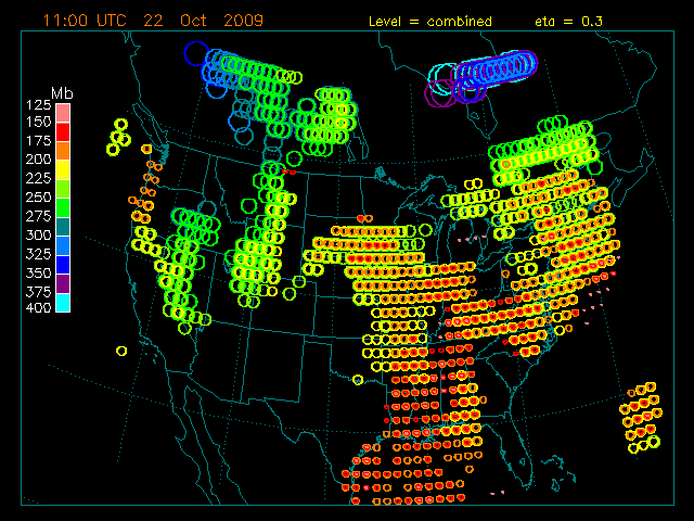
Last time I looked it was accurate for LA. You can also correlate this with the MODIS satellite images:
That’s a great tool for predicting persistant contrails. Can you send me a link?
http://www-pm.larc.nasa.gov/sass/contrail_forecast/contrail_prediction.html
You still dont to understand or acknowledge on the same day people can tell the difference between a regular airplane leaving a dissipating stream (slowly goes away as the plane zooms thru the fucking sky)
and a ‘stream’ that a plane leaves that lasts hours – hours- and slowly creeps and turns into a looming sprayed web like canopy
You keep talking your obfuscated crap and point at an orange and say its an apple – go right ahead
Well, clearly there IS a difference between those two types of trials. The question really is: can both types of trail exist in the sky at the same time?
The answer here is clearly yes, you can have short contrails, and long persistent contrails, in the sky at the same time. Persistent contrails require a specific combination of temperature and humidity, and these can vary greatly both between altitudes, and between regions of the sky.
…of course- do not forget the Contrail Factor-
The reality is such that 2 different planes can leave 2 different contrails in the exact same atmospheric conditions…the only difference being the engines…and the ratio of water vapor being added to the exhaust plume.
See here for more detail:
http://cat.inist.fr/?aModele=afficheN&cpsidt=13848340
“The contrail factor is the ratio of water vapor to enthalpy added by combustion to the exhaust plume from an aircraft engine. It is the key parameter determining the highest temperature at which contrails will form behind a particular engine on a particular aircraft.”
Today a watched the same plane leave three different types of contrails while it was gaining altitude and flying at about a 45 degree angle. It started with almost no contrail at all. It went through a patch of moist air and left a short persistant spreading contrail that formed cirrus clouds, as it climed higher it left intermittent contrails that quickly dissipated. When the aircraft reached its cruising altitude it left a fairly long contrail that slowly dissipated without leaving any cirrus clouds due to the lack of moisture.
You see dick, you can have different types of contrails as the aircraft passes through different atmospheric conditions. There’s no need to get mad at Uncinus for this, its not his fault.
Indeed. But one tries not to cloud the issue 🙂
45 degrees? To what? Most jets departing from, say, LAX, climb at around 4 degrees vertically.
The different types of contrail need not always result from a change in altitude. Just as the sky can be clouds in one part and clear in another, it can also be humid in one part, and less humid in another (with patches inbetween).
From the ground it appeared to be a little less than 45 degree angle until it reached it’s cruising altitude. I’ll snap a photo the next time and you can explain my bad judgement.
This particular air craft appeared south of the airport . I’m guessing that it didn’t depart from the Lubbock airport.
Well, some planes can fly at 45 degrees and above. Fighter jets and acrobatic planes can fly at 90 degress (vertically). It just seems like an unlikely angle to be maintained for any length of time.
I think it’s more likely that that plane was flying diagonally across your field of vision in a way that looks like it was flying at a much steeper angle. It’s a problem of perspective when looking up at something with no reference points.
Try this: take a pen, and hold it in front of you so it is pointing upwards. Rotate it right 45 degrees. Now raise your arm so your arm is at 45 degrees. Look at the pen, and imagine a plane flying along that line way up in the sky. It’s quite possible for a plane to fly in level flight, and still seem to be travelling along the 45 degree line.
This is one the problems that besets “chemtrail” observers, they can’t really tell what direction things are going in from the ground.
Uncinus:
Nor can they tell foreshortening, nor can they tell altitude. The lower atmosphere is seen to the horizon, whereas the upper atmosphere is seen to a hundred miles.
Chemtrails in a humid stratosphere will grow from span-width to a kilometre deep and several kilometres across and greater as the aircraft’s wave vortex continues to stir the mix – there may be, after all, sixteen tons of ice for every kilometer of trail.
This can easily give the impression that the far end of the trail drops, as the atmosphere seven miles up curves down to the horizon a hundred miles beyond the horizon’s cut-off.
Just a little thing on the Cirrus clouds. The mares tails usually form in Jet streams which are associated with frontal systems. They bring moist cold air from behind the cold front up to the front of the warm front which form the frontal system. These high altitude cirrus precede the approaching warm front by about a day. The wisps blow up at the turbulent edges of the jet streams.
Its not surprising to see persisting contrails in these conditions. There are cold humid conditions up there. This also explains the story about rain and halos round the sun following heavy chemtrail activity. There is a warm front approaching which usually brings thick cirro-stratus cloud which can give halo’s around the sun and moon. This might look like the trail are spreading but its actual the front most clouds of the warm front approaching. After that the clouds thicken and it begins to rain. Which support the cloud seeding theory.
Furthermore, Jet pilots love to fly trough jetsteams because they blow them on there way saving a lot of fuel. That means there are often contrails running trough the jetstream. The turbulent air in there makes the contrail spread out, causing the mares tails to form.
I see a lot of people commenting this stuff and telling me that every time they see persisting contrails preceding halo’s around the sun and moon and then it rain the next day. Its actually just normal weather systems passing over them.
Excellent information Wickid, thanks for posting. I like to put “chemtrail” in quotations when using the word, because not using them makes me feel as if I’m validating the term. But that’s just me, your points all stand as very solid with or without the quotes.
Mr Suntour
Suntour:
Funny, that’s EXACTLY the way I feel about that.
Maybe I’m anal, Wickid, but I believe the plural of “halo” is “haloes”.
And while I’m having fun, the genitive “its” has NO apostrophe, “it’s” is the shortened form of “it is”.
Boy, does that make me feel better! (Just watch it, Uncinus!) 🙂
Hopefully we don’t whip out the “argument by quality of grammar” now 🙂
Halo can be pluralized halos or haloes. “Halos” is more commonly found on the internet.
Uncinus, isn’t education by the internet how we all got here? And we’ve all seen some pretty ‘good’ examples of it’s efficacy.
I do agree with Sun, although I don’t always follow it. Kind of like my diet.
Internet info is obviously not always of the best quality. But Google is quite handy for finding the relative frequency of word usage.
“Chemtrails” should be in quotes because the usage has not been well defined, and is often applied to things that are obviously contrails. Much like you would put “UFO” in quotes when talking about something that has actually been shown not to be a UFO, like: The “UFO” was subsequently shown to be an errant garbage bag, blown by the wind.
HR 2977
[…]
(2)(A) The terms `weapon’ and `weapons system’ mean a device capable of any of the following:
(i) Damaging or destroying an object (whether in outer space, in the atmosphere, or on earth) by–
(I) firing one or more projectiles to collide with that object;
(II) detonating one or more explosive devices in close proximity to that object;
(III) directing a source of energy (including molecular or atomic energy, subatomic particle beams, electromagnetic radiation, plasma, or extremely low frequency (ELF) or ultra low frequency (ULF) energy radiation) against that object; or
(IV) any other unacknowledged or as yet undeveloped means.
(ii) Inflicting death or injury on, or damaging or destroying, a person (or the biological life, bodily health, mental health, or physical and economic well-being of a person)–
(I) through the use of any of the means described in clause (i) or subparagraph (B);
(II) through the use of land-based, sea-based, or space-based systems using radiation, electromagnetic, psychotronic, sonic, laser, or other energies directed at individual persons or targeted populations for the purpose of information war, mood management, or mind control of such persons or populations; or
(III) by expelling chemical or biological agents in the vicinity of a person.
(B) Such terms include exotic weapons systems such as–
(i) electronic, psychotronic, or information weapons;
(ii) chemtrails;
(iii) high altitude ultra low frequency weapons systems;
(iv) plasma, electromagnetic, sonic, or ultrasonic weapons;
(v) laser weapons systems;
(vi) strategic, theater, tactical, or extraterrestrial weapons; and
(vii) chemical, biological, environmental, climate, or tectonic weapons.
(C) The term `exotic weapons systems’ includes weapons designed to damage space or natural ecosystems (such as the ionosphere and upper atmosphere) or climate, weather, and tectonic systems with the purpose of inducing damage or destruction upon a target population or region on earth or in space.
Woops. I guess chemtrails do exist. They attempted to bury this boldly worded bill, but the internet has a great memory. Google it.
Google it indeed:
https://contrailscience.com/kucinich-chemtrails-and-hr-2977/
N. Eyes,
1) As Uncinus points out, the rep himself didn’t write the bill, nor read it until too late.
2) “Chemtrails” (if they existed) are not in space (at least literally). They are atmospheric, therefore their mention in the bill is moot.
3) By giving the “they are mentioned, therefore they must be real” angle on “chemtrails”, you would have to give the same weight to all weaponry mentioned. Therefore you would have to believe that all weapons mentioned are real, feasible, and USED now. I would think the disclosure that “extraterrestrial” weapons existed and are being used to be a much better, more important story than the spraying of some as yet unproven chemicals into the atmosphere for an as yet unknown reason, don’t you? Haven’t seen that on the web or History Channel mockumentory yet. Have you?
4) The bill, didn’t make it to the floor, therefore really doesn’t mean a single thing except that our elected officials should start reading anything before they sign and put their name to.
Some folk still call them Mares’ tails. 🙂
I found a great PDF on Contrails-to-Cirrus uncinus Morphology(Old info 4-U?)
Contrails to Cirrus—Morphology, Microphysics, and Radiative Properties
http://www-pm.larc.nasa.gov/sass/pub/journals/atlas_JAMC2006.pdf
Contrails Morph into Cirrus uncinus quite frequently, I have taken some great photographs of this happening over Vancouver BC.(3weeks ago)
is it pronounced; UngKinus -or- YounKinus ??
Yes that’s a great paper, I’ve had it in my links section on the left there for over a year 🙂
It’s pronounced basically as it is spelt: between un-ci-nus and un-say-nus. The plural is uncini, which make it a but more obvious.
Aha…. I see… Now I know where you get your username.
Initially, I read it as Unicus. I have some Unicus dice. They’re spherical… Quite clever little things… a nice little novelty… but clouds, they are not.
Paul..
The RoadRunner..
Cool site, it helps make insomnia more bearable. Here is a shot of what I guess are uncinus clouds over Lolo Pass Montana a few weeks ago. The plane was going right to left. The appearance and disappearance of the contrail looks like it defines the edges of a humid air mass. (It snowed a few days later.)
I guess/bet that the Cirrus uncinus in the start-post is a the result of a persistant contrail, the newer contrail might have merged well with the Cirrus uncinus into a newer Cirrus uncinus superimposed on it…..
Taken at midday yesterday here in sunny Scotland. Would I be right in thinking these are Cirrus Uncunis.
The Chemtrails hoax has had one benefit, it has made me look at the sky again, just like when I was younger.
[img]https://contrailscience.com/wp-content/uploads/002-1.jpg[/img]
Essentially yes, though these are a bit stubby and fractus. A classic cirrus uncinus has a longer sweep of tail hooked into an upper cloud,
Uncinus, I greatly admire your hard work and determination.
I achieved a participation in a TV show dabate against the main chemtrail activist in my country. I am planning to present mostly materials from yout site. But I’d like if you can help me with some very representative pictures, shiemes or graphics. You can sent them on my personal e-mail.
I think the best presentation of scientific view about contrail formation is on this site:
http://asd-www.larc.nasa.gov/GLOBE/resources/Contrail_Formation_English.jpg
Yes, that’s a great chart. But it also illustrates one of the problems with the topic – it takes a little time and attention (and some very basic understanding of the science behind water) in order to understand. So for many conspiracy theories, it might as well be in greek.
I can’t think of anything that’s not on the site. Perhaps you could be more specific about the claims you opponent makes?
Be sure to tell us about the debate. There is a link at the top of this page to a forum where I would be most interested in hearing what happens.
Uncinus&Jay
My opponent contacted me recently to ask me for some friendly conversation about my views on chemtrails.
Well, his arguments are quite naive – if contrails spread across the sky thy are not normal. I think the debate will be few arguments and lots of conversation gymnastics and overspeaking… My opponent is very used on TV performance, he speaks too much and constantly swears he speaks only the truth. That man is a professional conspiracy theoretic, so i think some attacks on commercial interest on the topic will be crucial.
You would be helpful in revealing who in fact are those people making the films like “What the world …” and why are they so determined? Do they make money from that?
Michael J. Murphy is a “true believer”, who believes in all the conspiracy theories. I don’t think he’s really doing it for the money, not yet at least.
G. Edward Griffin also seems to be a true believer, but he’s also making his living selling books and DVDs on a wide range of conspiracy theories (like, there’s a cure for cancer that’s been covered up).
I personally don’t think attacking the deny aspect is very productive. Better to attack the science. Attack the weakest point on which they base their argument. Be prepared with a buch of quotes from a variety of sources that show that contrails DO and ALWAYS HAVE spread out across the sky. Here’s some:
https://contrailscience.com/persisting-and-spreading-contrails/
If they then move on to “people think it has changed, they don’t remember it being like this”. Then you can respond with: “lots of people remember it being like this – a survey of conspiracy minded people on Above Top Secret showed that MOST people actually remembered it being like this”, and read some of the quotes from:
https://contrailscience.com/hazy-memories-of-blue-skies/
Thanks a lot Uncinus. Your work, though hard and tiresome is a heroic achievement.
I too look forward to reading/watching more on this debate, hopefully on a new Metabunk thread, if Weinlock has an account. (Might have to get some subtitles first by the sound of it.)
Here are some other background links on the video “What in the world…”(WITWATS):
http://metabunk.org/threads/137-Shasta-Snow-and-Water-Aluminum-Tests.
http://metabunk.org/threads/172-The-Claims-of-Michael-J.-Murphy-A-Factual-Examination
http://metabunk.org/threads/154-The-Claims-of-Francis-Mangels-a-Factual-Examination
Hello guys. There will be no debate. My opponent evetually refused his participation in the broadcast without a reason. Probably because he saw my determination for debunking him publicaly. He is quite reasonable man, I think.
Thank you all.