 Contrails are clouds made from water vapor that condenses then freezes behind a plane engine. Since the engines are on constantly, it seems a bit odd when you see contrails with gaps in them, or even contrails that stop and start. If the engine is pumping out a constant amount of water, then why is the trail not constant? This puzzle is sometimes seized on by people who think that persistent contrails are actually “chemtrails”, or some kind of deliberate spraying operation.
 But it’s actually very simply. The amount of water in the exhaust is pretty constant, but the amount of moisture in the air is not. The humidity varies with altitude, and a layer of low humidity can be sandwiched between two layers of high humidity. As a plane climbs or descends through this layer, then the trail will only form in the areas of high humidity, and so look like it was “switched off” in the area of low humidity.
You can get the same effect with temperature. A warm layer of air can actually lay on top of a colder layer in what is called an “inversion” (you’ll hear this on the weather sometimes, referred to as an “inversion layer”). When a plane flies through this inversion layer, the trail can be “broken”.
It’s not just climbing or descending flights either. The boundaries between these layers is not flat, and gravity waves or rising convection currents of air can create large volume of air that differ in temperature and/or humidity from the neighboring air, and so can break (or make) the contrail when then plane flies through them. You can think of these regions as invisible clouds:

This can be see in this 1944 footage (about 70 years old) from the WWII film Memphis Bell:
Don’t take my word for it though. Do a Google search for “broken contrail” and you’ll find lots of examples, and similar explanations (Click the photos above for two).
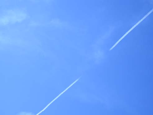
Occasionally a jet plane, especially if ascending or descending, will pass through a much drier or more moist layer of atmosphere which may result in a broken pattern to the contrail, with it appearing in segments rather than in one continuous plume.
If the contrail stops, then starts up again, creating a broken line, chances are the airplane flew through a dry patch.
What is happening here is that warm air rising from the ground carries vast amounts of water vapor upwards into the highest levels of the atmosphere. This water vapor exists as massive, plumes of warm, moist air ascending to very high levels. When a rising plume reaches the upper atmosphere it condenses into high ice clouds known as cirrus or feather clouds. In the case of the jet contrail (condensation trail) in the first image, the condensing cloud formed where the aircraft passed through a rising plume of moist warm air. The air on either side of the plume was not sufficiently moist to support the formation of an enduring cloud. As a result the contrail only remained visible in the warmth plume.
This uneven humidity does not always result in an instant on/off for the contrail, but can result instead in some regions of the contrail being more persistent than others. This can lead to a gap forming a minute or more afte the contrail originally formed:

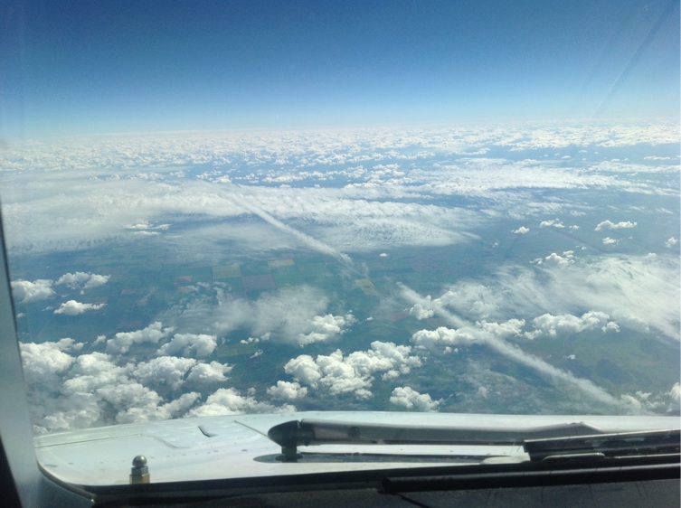
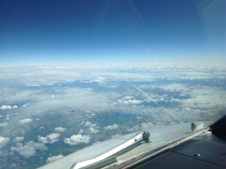
Here’s what it looks like from a pilot’s perspective. You can see that that clouds occur in layers, and they are very unevenly distributed. The pilot said:
“I was flying today above a layer of Cirro-cumulus and snapped a couple of photos of a contrail below me that may be useful in explaining the stop/start nature of some contrails.
The aircraft was actually flying inside the layer and generating quite a thick trail, which either stopped or thinned out where the cloud stopped or thinned out, and started up again where the cloud resumed normal thickness.
Once again, the contrail is not above the cloud layer, but actually inside it.”
Hi, Mick
I thought I’d let you know that JazzRoc, Epoxynous, and Doublemeat appear to be ONE.
A single AGENT SMITH in the “chemtrailer” park.
In the interests of sanity we three ought to group together… and rejoin our obviously SPLIT personalities. Just joking…
Jazzybaby
contrail science? to purport to talk of “contrail science” then hide your credentials is suspicious to say the least, i do not know of any scientist who would do extensive research on a subject and then not cite documentation or reference directly the “german research” etc then add to this not put his name to anything!
i put it to you sir that this site is no more than a selectively edited message board for a single viewpoint designed to do very little but misinform. i suggest that people refer to the wikipedia page on chemtrails as a start point not some anonymous site run by people whos reference material is cited as “some german contrail research”.
can i suggest you rename the page “contrail stuff” cos ive read every page and cant find any proper “science” anywhere.
“chances are” and “probably” which are words from your site whoever you are,are not really terminology used in scientific documentation unless probability math is your discipline.
Hi Anonymous, I do actually try to give sources wherever possible. Like in the article above, I give three fairly authoritative sources: the NOAA, Airspace Magazine and Doc Weather.
There has been a lot of “German Research”, so I’m not sure what you are referring to, but it was probably something from here:
http://www.dlr.de/pa/en/desktopdefault.aspx/
If you find any errors in my site, I’d be happy to correct them.
Good site!!!
My name is Heriberto, I am an argentinian-spaniard psychologist living in Madrid.
The “chemtrails” are explained: they are contrails.
What remain unexplained is the sociopsychological aspect of the problem: why people believe in such a weird thing?
I am investigating the possible answer in
http://espacioexterior.blogspot.com
Greetings.
Why do people believe weird things? Good question.
I think people subconsciously like to believe in conspiracy theories because it gives them a sense of control and understanding of a world that has become too complex for the average person to fully understand.
By attributing their woes to a malevolent higher power, they simplify the world, removing doubt, and raising their perceived status above the “sheeple”.
Yawn, yawn, yawn, which gov. agency is sponsoring this site? You can fool some people most of the time, but you will never fool everyone.
This is an obvious clandestine operation. Conspiracies are ongoing,’I think people subconsciously like to believe in conspiracy theories because it gives them a sense of control and understanding of a world that has become too complex for the average person to fully understand’
What an absolute crock of crackpot psychology. What we understand is all of this is a lie.
Hi Doc, I take it by your lack of pointing out inaccuracies here that you don’t actually disagree with anything I’m saying, but just think I’m using the truth to confuse people?
If not, what exactly have I said that is incorrect?
I think the reason folks believe so easily in conspiracy “theories” is because history so readily proves reason to be suspicious of government! I used to give the benefit of the doubt. Now, well, like government treats its own US citizens, guilty until proven innocent. (ever been audited?)
There is much controversey regarding the 9/11 investigations. And gov’t officials don’t seem interested in continuing research pertaining to the worst “war” crime against the US in history. If there is nothing to hide, then continue the investigations!!!
Cloned farm animals have been approved by the FDA as “safe” for human consumption (when there is NO reason to be cloning farm animals to begin with. There is NO shortage of healthy meat and the FDA’s own studies along with many others show LOTS of issues with cloned animals) Genetic seeds by US companies are being forced down the throats of other countries (read Censored 2008) and devestating their farming communities! We’ve had dangerous genetic crops, i.e. Roundup ready corn, for quite a while. Our gov’t is allowing us to EAT poison, why shouldn’t we believe they are spraying it in the air now as well?
The FDA allows us to be used as guinea pigs. They protect big drug companies and food companies all the time.
I could go on and on…WHY do we believe in such conspiracy theories??? PLEASE…..Give us reason NOT to.
(this site has given me pause, though….THANK YOU. I don’t WANT to believe such horrendous acts are being taken by gov’t against its own citizens!!)
I came upon this just recently when I began researching information regarding Morgellons because a friend of mine’s sister has it! I read about it first about 5 years ago before it had a “name”…
To NOT acknowledge that possibly something is being released into our air…and a connection to this bizarre affliction is absurd. ALL possibilites should be considered.
Have you read the patent for HAARP? U. S. Patent 4,686,605. and the FAQ at http://www.haarp.alaska.edu/haarp/faq.html
Be warned there is a disclaimer at the HAARP website advising you that you are on gov’t property and will be watched! The day after I was on that site I got a message from my McAfee that a program was trying to download to intercept and redirect my computer data! And I should NOT be suspicious of the gov’t????!!!!
You’ve got a live one here, my friend. Can’t wait to get a response!
I try to stick to contrail science. Sure, the government COULD be doing all kinds of things, but where is the actual scientific evidence that they are making “chemtrails”.
Sure, I have no evidence that they are not – but that’s not a reason. There are an infinite number of things I have no evidence that the government is not doing. I have no evidence that they did not fix the superbowl – does that mean they did?
So WHY would you believe in contrails IN PARTICULAR.
Show me one scrap of solid evidence.
You’d mentioned how clear the HAARP site is on another thread..I’m merging that comment into my response now to explain why I believe chemtrails could be real.
Yes, the HAARP site IS quite clear: they state it is not for military operational use, yet the military requested its construction and manages it. That doesn’t make sense.
The patent # 4,686,605 for this “device” states Under the “Claims” section:
2. The method of claim 1 including the step of providing artificial particles in said at least one region which are excited by said electron cyclotron resonance.
3. The method of claim 2 wherein said artificial particles are provided by injecting same into said at least one region from an orbiting satellite.
4. The method of claim 1 wherein said threshold excitation of electron cyclotron resonance is about 1 watt per cubic centimeter and is sufficient to cause movement of a plasma region along said diverging magnetic field lines to an altitude higher than the altitude at which said excitation was initiated.
It further states;
injecting charged particles from a satellite carrying a payload of radioactive beta-decay material or alpha emitters; and injecting charged particles from a satellite-borne electron accelerator.
AND it says:
It has also been proposed to release large clouds of barium in the magnetosphere so that photoionization will increase the cold plasma density, thereby producing electron precipitation through enhanced whistler-mode interactions.
NO, this is not a “smoking gun”…..just building a case. It certainly is cause for suspicion. If it was proposed to release “artificial particles” via satellite, why NOT use planes? Even in a court of law, enough circumstantial evidence can result in a guilty verdict. AND, like in a court of law, if the “accused” is shown to lie about other things, it lends to their character.
The HAARP experiments interact with the ionosphere. The ionosphere begins 30 miles above the surface of the earth and extends up to around 250 miles. The highest passenger jets fly at about 10 miles (with the vast majority at around 4-6 miles).
That’s why the proposal talks about using satellites.
That is why they would NOT use planes, they can’t fly high enough.
Yes it does. It’s a research facility, and not an operational facility. It has no real ability to DO anything other than excite the ionosphere in a spot for a few minutes.
The military’s interest is partly explained in the FAQ:
You didn’t respond to the patent that states a proposal for releasing barium clouds…….
I wonder if the “excitement” in the sky they conduct is visible?
We had a sky full of clouds with squared off edges that fit perfectly into eachother…horizon to horizon. I’d never seen anything quite like it. The spaces between the jagged clouds were the same width as the clouds. As the clouds left the area, there was a definite “pattern” at the edge of the cloud line as well.
I felt like I’d stepped onto an X-Files set. I sent copies to two of our local meteorologists and never got a response.
When I saw the explanation of “dropping a stone into a fast moving stream. The ripples caused by the stone are very quickly lost in the rapidly moving water and, a little farther down the stream, are completely undetectable.” I got chills, because the clouds DID look a lot like a ripple effect.
I just saw another patent regarding releasing a metalic substance in an attempt to reflect sun and offset global warming. USPatent 5,003,186. That one DOES call for using planes/jet fuel.
And a question: At 30 miles up, would gravity pull particles toward earth?
I addressed the “clouds of barium”.
The Magnetosphere starts in the ionosphere. Same thing.
Okay, ripple clouds. Now you could just look those up. But let’s narrow it down to books published between 1900 and 1910
http://books.google.com/books?lr=&as_brr=1&q=%22ripple+clouds%22+date%3A1900-1910
See the book, “Cloud Studies”, by Arthur Willian Clayden. Published in 1905, written before the invention of flight. You can download the whole thing as a pdf, or read it on google books.
http://books.google.com/books/pdf/Cloud_Studies.pdf?id=TmhDAAAAIAAJ&output=pdf&sig=swDZcBiZGCy_3dOIg85oP12wx-c
Chapter VIII, page 119, (page 241 of the PDF), is a chapter on “Wave Clouds”. go through that chapter and look at the photos, and let me know which looks like the clouds you saw. I suspect it’s Plate 55.
Thanks for the info. That link you gave for “ripple clouds” ARE similar to what I saw. I appreciate the reference materials. I’ve seen small sections of clouds looking like that before, but not an entire sky’s worth with jagged little “rays” on the edge.
They were quite amazing to see. Perhaps it may be more in the way of proof of intellegent design…(only not of human form) :o) It was beautiful, yet eerie.
Nah, it’s just nature. Nature looks pretty sometimes.
You should have a look at the Cloud Appreciation Society. They have a nice gallery, that has some way more amazing clouds.
You should also look up “cloud streets“
Ah, yes, my friend but somebody MAKES nature!! ;o) To think this all happened from some “Big Bang” or accident is like saying a print factory exploded and resulted in the Webster’s dictionary.
I’ll definitely look at the Cloud Appreciation Society. And I’m still not TOTALLY convinced that there ISN’T something sinister going on. There seems to be an awful lot of conversation regarding it, from all over the world. It warrants some investigation. I’m just trying to weigh all sides and quit freaking out everytime I look at the sky! LOL.
Good site, it challenges people to really use the brain! In fact I am convinced that artificial trails (=purposely created) exist for real. Yes, the author of this site is right for the most trails which for real are natural and not artificial. But if just only one trail is artificial all the epistemic castle would fall down in a nano-second…..
Chemtrails: this is a global wide psy-operation to make the most sensible, critic, intelligent and not submitted people to waste their time with the nose in the sky. It works in this way, (thanks the helps of an army of psychologists, psychiatrists, experts in social communication, etc.): some aircrafts spread some water at un-usual altitude or in an un-usual geometry. Then a particular social layer of people (the one I talked above) will find in the web all the ‘conspiracy’ sites backed by the same agencies (see the psy expert above) who are doing the aerial comedy (I call them no Chemtrails but Showtrails). As explanations they’ll find every kind of theory, as what matters is: to make waste the psychical energy in a wrong direction. This is a normal way to proceed by govt. agencies, which work always using the psy-warfare manuals, expecially the ones based on Sun Tzu not conventional warfare. It works fine 100%, guaranteed by Adolph and Stalin!
So even if people are wrong (as regard my particular conviction about the goals of artificial trails who is a giant psy-op) as I don’t believe in HAARP or similar, I support all their ‘conspiracy theories’ because they are expression of FREEDOM OF SPEECH and FREEDOM OF CONSCIENCE, something that from day to day is more and more dangerously lacking. The most fine strategy to kill FREEDOM OF SPEECH /COSNCIENCE is to call it with a terminology taken from the world of the Nazi psychiatry: “YOU DON’T HAVE RIGHT TO SUSPECT OF YOUR GOVERMENT AND TO EXPRESS IT BECAUSE SUSPECTING YOUR GOVERMENT IS A SIGN OF MENTAL ILLNESS”.
Is it the Psycho-Bolschevik regime of New World Order?
Best regards – avles.
Avles – so you think that chemtrails don’t exist, but the chemtrail theory was cooked up by the government to keep freethinking people distracted from what is REALLY going on?
I’m afaid that without evidence, that just sounds silly.
Many fact finding and life treatening problems started from conspiracy theories. It’s good and healthy to think.
What about the woman who fought for MTBE additive being dangerous? She was touted as a nut right from the beginning. Thankfully someone paid attention. But tha’t only one small step for human-kind.
On the Conkemtrails. Please produce some photographs prior to 1999 showing this anomally or ‘phenonenom’. How can flight patterns produce waffle-like grids of contrails in the sky? Scientifically why are there huge X’s in the sky for as long as the eye can see? I’d love to here the explanations to this. Let’s go…
According to professors aren’t Ionospheric heaters able to artificially move the ionosphere lower or higher, this being part of the experiments. I have read some on this and watched some science documentaries on this, they could be all wrong though.
Uncinus
No. See here:
http://www.haarp.alaska.edu/haarp/ion4.html
It heats it up, if anything this would move it higher, but really it’s just heating a small region. The point is still that contrails form about 25 miles BELOW the ionosphere.
Hi unicus,
As a commercial pilot, I cannot believe how people with so little meteorological knowledge can claim they know all about cloud formation.
I was watching the wonderful shot movie “Les Chevaliers du Ciel (Skyfighters)”, when I came across a very nice example of gaps in contrails.
http://nl.youtube.com/watch?v=-3ZPDX68_Dg
In this clip at 1:36 you can see 2 Mirage 2000’s producing contrails. As the one on the right moses to air with different propeties the contrail disappears, only to appear again when he moves back.
haha 99% of ppl who believe in chemtrails think they know everything about meteorology, or yet seem they think they do. try asking them technical stuff and they have no clue. they just verbaly take it off subject with a stupid remark.
I think you got it spot-on why people do believe these things.
But they are hard to ‘debunk’, since they’re never really proven by the people themselves.
They observe 2 totally different things (contrails that stay for a while and increased pollution) and then they link those two things together without any argumentative basis.
Then they move on by: “prove me wrong.” While to be scientifically correct, they should first of all prove themselves right.
And naturally, it is impossible to prove them wrong, since any reputable source like scientific institutions, government institutes of all kinds, people with who actually are real experts on the issue ofc are part of the conspiracy. People like you who can give fairly straightforward explanations must be bought by government or are “sheep”.
But any person that clearly says he isn’t familiar with the subject, but took sciences classes and ‘knows’ it can’t be natural is ofc unbiased prove, people who do some observations while they don’t even know that 1 milligram isn’t 10 microgram, but 1000 microgram are scientific observers…
They call themselves critics, but they don’t notice the obvious mistake in readings?
I’m so extremely happy that you’re doing this, at least one piece of common sense on the internet.
I hope you keep it up, it really is enjoying to see someone point out obvious faults in their ‘science’ and giving the straightforward explanations that can actually sustain real scientific critique.
Kind regards,
Shorack
Very interesting discussion. You can find out inmediately about the topic if you take a large metal pipe (more than a meter we would recommend) and point it directly into your dizzy and strange skies.
After less than a day your skies will start changing. You will recover blue parts, you will recover nice sunlight, you will recover soft and contínuos raining. This just with a pipe. If you build your own chembuster or cloudbuster a bit more professionally, then these results will appear quicker, and even clearer to you.
But even a large metal pipe, pointing into the chemtrails, will cut them within minutes.
Find out about the truth. Just find a stupid metal pipe and have some fun.
Vortex, the exact same effect can be achieved with a cardboard tube. It’s called the “observer expectancy effect”. You are not altering the weather – the weather is just changing as it always does.
You know, it’s not “your skies” – millions of people can see the same skies you can – so if all it takes is once guy with a metal pipe, then what’s the problem?
I’m afraid you are just fooling yourself.
German Military admitting they use chemtrails earlier this year. Was on the German main news earlier this year. Chemtrails dont exist he he well i guess you fucked it up bigtime Mr “Clandenstine”
Inge, the German Military simply confirmed that they use chaff, which all militaries use, and is not a secret. The German word for chaff is “duppel”, and someone deliberately mistranslated this as “chemtails”. See here for the full story:
https://contrailscience.com/germans-admit-they-used-duppel/
Hi there, thanks for the site.
was wondering if you would be ready to spread the discussion a bit!
There is indeed a lot of concern about global warming — globally 🙂 The scientific lobby clearly has to find the answers itself. As per my analysis and models, the primary player is water vapor itself. Its concentration goes on increasing exponentially with temperature, and absorption with concentration. Hence the rate at which the planet is heating itself up is but proportional to the exponent of its temperature! On the other hand diffusivity falls exponentially with temperature, which means (exponentially) more hetrogenous distribution of this vapor/temperature, meaning higher probability of a convection current sending this heat out of the atmosphere.
It all comes out to mean that the probability of the next ice age showing up in the style depicted in the movie ‘the day after tomorrow’, increases exponentially with — time.
I guess everyone feels so much better now — thank me — the scientist with good news for all. 🙂
yes buddies — good news for all — ‘you cant fight em, join em’. Who ever suggested controlling the climate? lets just play along. Vapor can give us heat, convection (wind), and evaporation can give us (local) cooling — so whats keeping us?
I assembled a commercial design of mist being sprayed in the air passing a wind turbine, the temperature gradients and density change introducing convection: increasing wind speed. The last piece of the jigsaw i need is the variation of humidity/vapor pressure/dewpoint with altitude. So far I have a model which takes up the data for any city and lets you know how economical is how much of a setup going to be. In cold areas you won’t appreciate the cold dewpoint wind yet the same would be an extra treat if your area is above the 25C mark. The energy is delivered as wind before the turbine converts it to more usefull electricity — so you might already define some limit on how much wind can you live with.
Control over wind speed gives you steady generation — as compared to the normal practice of waiting for the wind to blow. The only variable you have to adjust then is the mist flux you are spraying (kg/s) — and then this consumes (a part of) the increase in generation.
The technology is free — no patents claimed, no carbon released. cost effectiveness (net W/m2) increases with (turbine) blade length.
Dr Tajir, I’d like to keep the discussion to contrails. Perhaps you could apply your model to contrails and discuss the effect of current contrail vapor and cloud cover on the weather. Then how could contrails be modified to deliberately modulate this effect?
hi. i wanted to know can a short-lived contrail form above a persistent contrail?
Yes. Conditions for persistent contrails form in a region where the temperature and humidity are just right. Above and below this region you will see short-lived contrails.
i do not care for contrails at all, because i am not a scientist. However why in the world are there so many JETS flying other Chicago in a CHECKERBOARD pattern? What is the logical reason that JETS have to fly about twice a day (9am – 11 am) and then 4-6pm, with occasional 1 – 2 day breaks? That was not the case until last year.. i live here since 2004 and do sky photography of clouds a lot… and last fall is when i started to notice these strange JET patterns
Hi anon, the reason for these patterns is the weather. Jet’s normally fly over Chicago on regular scheduled routes. Sometimes the weather allows contrails to form and persist. The strong high level winds and multiple planes makes some kind of grid inevitable.
Do you have an online photo collection?
@Uncinus: You misunderstood the question. I do not care for the contrails. I care for the checkerboard patterns that are NOT normal
besides, 12 or > jets in the sky at the same time on routine bases could not be ordinary.. Planes yes – JETS that fly faster than speed of sound – no. Just concerned, because those are military jets and thats citizens tax money burned in hundreds of thousands weekly, just over Chicago
Here’s a photo from life magazine from 1970 (click on it to verify)
Now, sure there’s only two planes, but given the volume of traffic we have now, then can you explain how there would NOT be grids? Some planes fly north-south, some east-west. They form grids. What’s the problem?
How do you know they are travelling faster than the speed of sound?
Did you look at how much traffic you have over Chicago? Not landing or taking off, but flying over:
http://flightaware.com/live/airport/KORD
Click on the map in the upper right on that page, then look at the green flights.
because by the time sound reaches the ground, the jet is long gone out of sight – simple conclusion, the speed of the JET is faster than sound, no other evidence required. I am not concerned with commercial flights from the map you provided. Considering the image to appear on life magazine cover, and in the Getty images – it’s not something you would see daily in the 70’s. Even eight years back seeing a military jet would be a hell of a sight. So what’s your point, come again?
oh and your link is a fake.. you grabbed the image id straight from the getty images and input it into the life magazine. Here ‘s a little tutorial how to do just that nifty trick: go to http://www.gettyimages.com/Creative
in search box type in jet, pick out any jet image (i choose the one with lady waiving a rag) and click it. In the pop-up find the ID (heres an example of the string which contains it – http://www.gettyimages.com/detail/200335636-002/Stone?axd=DetailPaging.Generic|1&axs=0|85375635%2c200………abrvted the # 200335636-002 is an id.. now go and input that into the link of life magazine image GRABBER http://www.life.com/image/72931188?xid=embedimage72931188 change the ID our friend Uncinus used to the image we are grabbing http://www.life.com/image/200335636-002?xid=embedimage200335636-002) – VOILA end result http://www.life.com/image/200335636-002?xid=embedimage200335636-002 ………!!!!!!!!
now try and prove that it was on the cover of the 1970 edition of life magazine
something faulty in your scientific methods .. smells like you are a deceiver
according to your logic all images on getty site were in life magazine at some point?
oh almost forgot – the smel….. l delicious
LIFEembedDrawImage(72931185);
am.. seems like you are an admin i cannot use html here…
I don’t think it was on the cover, it’s just a photo in Life’s archives, and it seems the copyright is owned by Getty. I found it via searching the life.com site, here:
http://www.life.com/search/?q0=contrail&date=1970-1970
Do you dispute that it’s a photo from 1970? I’ve got lots more.
well i do not trust anything you have to say any further .. i will await until the image that i’ve submitted gets cached and search for it … to verify your statement. Read the comments to answer your question. I do not dispute it’s from 1970
hmm.. what were the keywords for your search?
Well, all I said about the photo was:
So, the basic point stand regardless. How could there NOT be grids?
The keyword was “contrail”, and I adjusted the date to 1970, this gives you this link:
http://www.life.com/search/?q0=contrail&date=1970-1970
(Click on “Edit” next to the date in the left column to edit the date)
you’re right /… there should be grids
reason for my concerns was not seeing these over chicago until the past year and a half.. maybe i just noticed them at that time
Most people don’t really pay much attention to the sky, so even if they see things like grids of contrails, they don’t really take note of them, and hence don’t remember them.
Unicinus, you seem to have an answer for everyone:
If the government is spraying in the ionosphere and manipulating some 30 miles above where planes fly, doesn’t that still impact our system? Also, if they are manipulating there, why wouldn’t they be doing similar work below, with planes instead of satellites?
Do they have to display there actions on an FAQ online for it to be possible that they would do this? Also, I understand having scientifical evidence to back this up and prove it right or wrong, but we are stuck here bound by gravity and the ones privelaged enough are the ones up there experimenting. How could we prove it? Seems we only have what they tell us, unless you have the capability to do such scientific experimenting.
B
Uncinus, you seem to have an answer for everyone
Hey B, you seem to have a question for everyone.
If the government is spraying in the ionosphere and manipulating some 30 miles above where planes fly
That’s a difficult spot to reach. It could be only be done by sounding rocket from below. Such rockets are always visible, and would always get a mention in the news – unless they were very small, and launched into an overcast daylight.
If your concern is about putting a small cloud of metal ions into the ionosphere to test radio reflectivity, that would be a matter of a few pounds of material and entirely inconsequential compared the area and volume of the planet.
doesn’t that still impact our system?
No.
Also, if they are manipulating there
Manipulating what?
why wouldn’t they be doing similar work below, with planes instead of satellites?
They cannot be using satellites. These fly outside the atmosphere. If they flew through it, they would be slowed by it, and fall out of orbit. Orbital satellites do so eventually when the reaction fuel used to orientate the satellite gets used up. They are hardly likely to contain other materials to be “dispensed”. I can’t ever recall a ‘tanker’ satellite…
If you’re talking “chemtrails” – persistent contrails are composed of ICE. They are frequently visible on radar screens.
Do they have to display their actions on an FAQ online for it to be possible that they would do this?
No. But they cannot ‘invisibly’ launch rockets either. And every pound of payload is accounted for. Military excepted.
Also, I understand having scientific evidence to back this up and prove it right or wrong, but we are stuck here bound by gravity and the ones priviledged enough are the ones up there experimenting.
The only people experimenting ‘up there’ are in the International Space Station.
How could we prove it? Seems we only have what they tell us
Prove what? What they tell us is in agreement with what we see!
For goodness sake, get one of those HEPA air filtration devices and test your own air.
Please remember when you have it tested that there is no way possible to link the pollutants in a ground level sample to anything you see over your head where contrails form. This point seems to baffle so many on “chemtrail” sites, who routinely sample ground level air and water and base their assertions that “heavy spray days” ,when lots of contrails are visible and persist, are actually polluting their backyard. You can’t even link what might be in a rain drop directly to an exhaust plume. To find out what is in a contrail, you must sample the trail itself.
I read an interesting article about conspiracy theorists brain patterns. It mentioned something about how people who fall victim to these crazy beliefs tend to use a different part of their brain for reasoning.
They have something in that part of the brain that releases dopamine when they think they discover patterns in otherwise random occurrences.
I wish I could find that article again. It really made you go hmmm. They do seem to get excited when they learn about some new link that they feel proves their point, and allows them to disregard actual proof.
Av8er: here are some links:
Psychology Today:
http://www.psychologytoday.com/blog/is-your-brain-culture/200907/krzysztof-kie-lowski-and-correlation-causality
Krzysztof Kieślowski:
http://en.wikipedia.org/wiki/Krzysztof_Kie%C5%9Blowski
Textbook of biological psychiatry By Jaak Panksepp:
http://books.google.co.uk/books?id=yeLKvgbrcxgC&pg=PA53&lpg=PA53&dq=Jaak+Panksepp+SEEKING+system&source=bl&ots=8oyFoDW-Md&sig=jGePiGn0H2Qrayz30e-7IW5POFc&hl=en&ei=XC16SpzUKsLDsgbhhe2kBQ&sa=X&oi=book_result&ct=result&resnum=1#v=onepage&q=&f=false
When analogue TV goes the way of the dodo such people are going to be deprived of the “no signal” visual screen noise, which digital technology has sidestepped…
There must be some link with optical illusions in general, but the rotating cube illusion (it goes either way but some people insist only one way) must also be connected, I think.
I’ve been to this site pretty much recently, researching discussiion of chemtrails on other boards. It’s a great resource…and now, perusing some of the comment sections, I am seeing a lot of the same claims.
Thanks for the site…will recommend it to all.
I found this in ten seconds, I can keep finding more evidence that the governments do experiment on populations.
http://www.guardian.co.uk/Archive/Article/0,4273,4398507,00.html
Hope this helps.
Unfortunately not. The questions being asked here are:
– Are contrails now different to how they were 20 years ago?
– Is there any evidence that there is something being sprayed in the form of contrails?
That the UK government, decades ago, chose a very small number of times to test dispersal patterns of analogs of biological weapons, is not really relevant.
Sure, the government might be testing super secret stuff on the entire planet, but is there any evidence that they are actually doing it?
I really should write a post on this.
“I really should write a post on this.”
Yes, please do. There are so many people that believe the well documented testing in the UK, is somehow proof that the lines we see in the sky today are full of chemicals. That is much more than a stretch in logic! It’s an assumption with zero evidence to support it yet so many people present the UK tests as “in your face!” proof! I’m not even saying that “the government” is NOT spraying things in the atmosphere. I’m saying that persistent contrails are not EVIDENCE of any such program. The science that explains persistent contrails is basic and simple. Some people don’t trust science/scientists and assume they are lying about contrails but, in this case the science is unquestionable! When a jet engine burns fuel in varying atmospheric conditions, persistent contrails will or will not appear BASED on those conditions.
I guess it’s just easier to point to the sky and claim “the government is doing that!”. That way, the science becomes less important.
Uncinus:
The man to contact is “Icewhale”. I believe you know of him. He seems to have amassed a wealth of detail on the subject.
I took this picture of several broken contrails south of Anaconda MT. Within a few hours thunderstorms began to build up. The same pattern happened the previous day, persistent broken contrails in the morning followed by thunderstorms in the afternoon.
[img]https://contrailscience.com/wp-content/uploads/DSCN0295.JPG[/img]
Don- nice picture…Montana sure is beautiful…
persistent contrails are often found preceding weather fronts as the moisture increases in advance of the front…
The chemtrailers are whining for some more broken contrail evidence from pre 1997…*sigh*
Now they want video evidence filmed IN america, from before 1997.
Does anyone know of any?
[Admin: edited for politeness]
Why video evidence precisely? And a video of what? A contrail being formed with gaps, or a later contrail with gaps?
There’s Memphis Belle, at around 0:40
http://www.youtube.com/watch?v=wfOrez6q7WM
It’s easy to make a video of something common now, and then claim it never happened before 1997.
For example: I see cars turning right at a red light every day now. There’s lots of videos on YouTube of this happening. I could claim it never happened before, and as proof note how difficult it is to find pre-1997 video of this. If it were so common, then why no video before 1997?
weathermodification.com
Cloud seeding exists and happens everyday. Look into the chemicals used and how toxic they are.
Look into scalar wave technology too while your at it. You cannot pull the wool over the sheeples eyes any longer!
Of course cloud seeding exists. Who ever said it did not? It’s existed, quite openly, for decades.
“Scalar wave technology”, on the other hand, does not appear to work. It’s been a theory for decades, but NOBODY has presented a working demonstration of any aspect of it. See:
http://skeptoid.com/episodes/4121
Once again they’re spraying the shit all over the sky here on the west coast while banking and doing bizzare manoeuvres.No plane shows up on flight tracker to correspond with these chemtrail sprayers.Full zoom with a 200x video camera shows aircraft identified 100% as a Boeing stratotanker.several chemtrails this morning have grown to several miles wide.how anyone can continue to peddle their mumbo jumbo bullshit to explain this shit away as normal and constantly berating and belittling people who know dam well this bullshit is going on in the sky is mind boggling.you’re not fooling anybody with your bullshit explanations.
Assuming you identified it correctly, that just sounds like a Boeing stratotanker doing maneuvers, and leaving a contrail. They are refueling planes, and so have to practice high altitude holds and formation flying.
Uuhhhhhhhhh sure absolutely.6-8 Boeing stratotankers doing formation flying,holding paterns,refueling over Vancouver island, georgia straight,YVR,Fraser valley.that’s just as disturbing as any conspiracy idea.none of these tankers are on flight tracker.
Overheard over the panhandle of Texas today:
ZFW (fortworth center)- “Gaser One (local air refueler), how many are in your flight (formation) and where do you want to go?”
Gaser One- “Gaser One is a flight of three and we’d like the Abeline 360 at 30 block 200 to 250.”
ZFW- “Gaser One and flight I can can give you block 200 to 250 but you need to remain within 25 miles of point Bravo.”
Gaser One- “understand 25 miles of Bravo and we’ll be joining Mustang 20 and flight and point Bravo”
ZFW- Roger advise leaving point Bravo.
Mustang and flight had checked on as a flight of six- that would bring everyone in that area to a total of 9. And that was just practice aerial refueling.
Hmm, what’s more likely, airplanes flying common patterns and manuveurs, or a vast, yet secret conspiracy poisoning everyone with clouds that look and act just like regular clouds? Well….
If you have to ask then you are part of the conspiracy!!
😉
Since coming across the site several days ago I’ve been paying more attention to the sky and whether or not contrails are forming. (As the “chemtrailers” say, I’ve been “LOOKING UP”! 🙂 ) It being the middle of summer here, there haven’t been many persisting ones, but I was super excited to see a persistant contrail being formed yesterday evening across a patch of cirrus clouds. As the plane reached the edge of the patch of clouds, the trail abruptly stopped. It was fun to see the science you and your commenters have described being displayed right overhead.
Here’s a pair of broken contrails east of Missoula Mt. Given that the wind aloft was from the west, you would think the evil chemtrail sprayers would have started spraying sooner. http://www.flickr.com/photos/23839726@N00/7933037674/in/photostream
Yes but do you have proof for all of that? And most of those words have been addressed here in previous posts. Sesquipedalian isn’t even possible though. Fun.
Thank you very much for explanation.I learn much about contrail.
How contrail make different colors?
There’s two ways, they can reveal segments of a solar halo by depositing ice crystals which refract and reflect light, or the aerodynamic type contrails can create colors due to interference from the water droplet, which vary in size as they are growing. See:
Halos:
http://www.atoptics.co.uk/
Aerodynamic rainbow contrails:
https://contrailscience.com/aerodynamic-and-rainbow-contrails/
How can you tell if an aircraft is ascending or descending by looking at the contrail?
^^ With no other frame of reference, like from a pic of the sky, and no visible planes. Like after the fact, from a pic, how can you tell?
Tough to tell without other references. Easy to infer though.
OK so how?
What characteristics should I be looking at to make such an inference?
I would look for changes in contrail formation, obvious penetrations of cloud layers, knowledge of probable points of descent on popular arrivals. its pretty hard to see these events, I’ll admit. What are you trying to determine?
[IMG]https://encrypted-tbn1.gstatic.com/images?q=tbn:ANd9GcRV7ywXu4n4qGP4pLZ4c0zttkL09DF5M-eOtCpx3oYyezuanSMB2g[/IMG]
Not sure if that pic will show up. Heres the link.
https://encrypted-tbn1.gstatic.com/images?q=tbn:ANd9GcRV7ywXu4n4qGP4pLZ4c0zttkL09DF5M-eOtCpx3oYyezuanSMB2g
Can you tell if these are ascending or descending?
no- i can’t but i would confidently say they are not. or at least the most dominant ones are not. looks like lots of level flight to me.
that last comment was from me by the way
go and study a bit of geo engineering and then come on that talck on contrails…hehehe…selling ignorance instead of information…people believe on what they see with their eyes…and they have memorie…there is a lot of people in the world that likes observing nature and notices the diferences…and if you study a bit, not this personalized approac to the so called science, that is worst fundamentaed the many crazy conspiracy blogues…go and study Keith, caldeira, the work of the council of foreign relations, the meetings of UN about clima change and clima engineering…don´t spread ignorance and mesinformation because this is why a lot of people gets crazy on the subjects…this is no better then the crazy theories sites…and it´s fulled of crazy personalized theories…go and study athomsferical condensation, the effects of aerossol, on moisteur and on diferente hights, go na study abou the cloud albedo enahncement….then talck about things…this is no more then ridiculous…
I have studied those things. Was there something specific?