UPDATE – After getting a new photo of the trail, Liam Bahneman told me he was now siding with it being his second choice, UPS902. Having reviewed the evidence, I fully agree that UPS902 is a much better fit than AWE808, especially when viewed against the composite photo.

UPS902 Turns out to be a much better fit
Note to everyone else – If you have photos of the Nov 8 contrail from any angle, please email them to [email protected]
[This post was originally from Jan 19th, 2010. I’ve updated it with information about the “Mystery Missile” contrail of Nov 8, 2010, at the bottom of this post. Clearly, it’s the same thing]
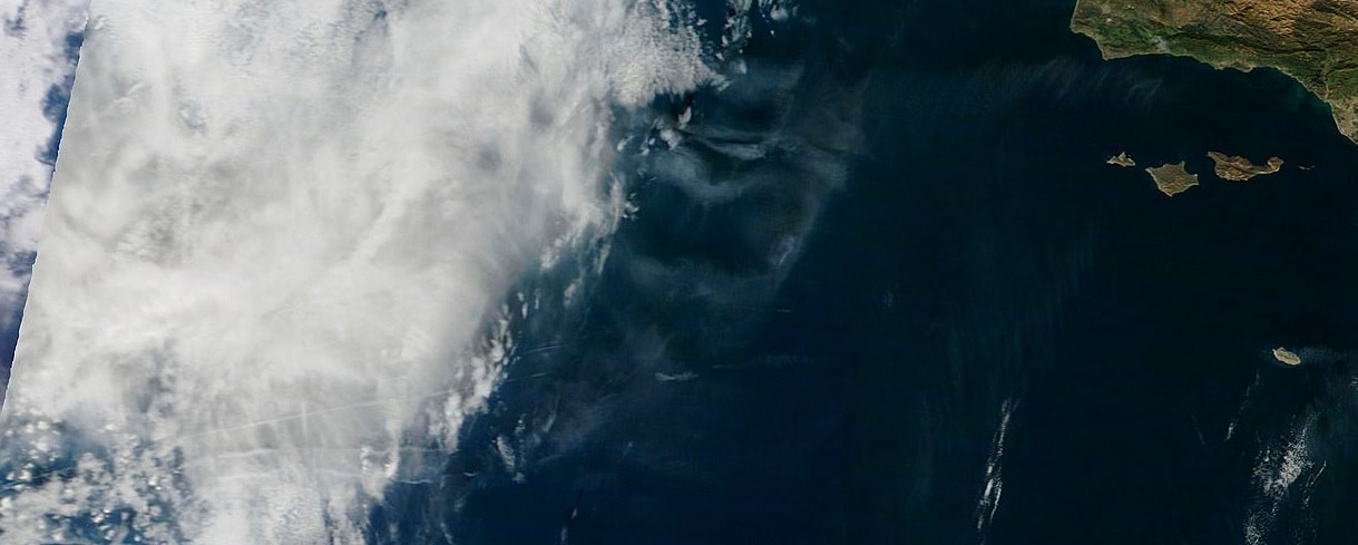
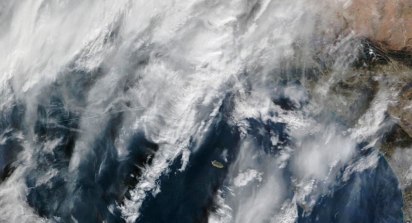
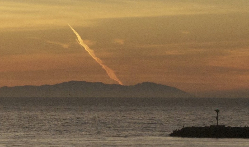
An interesting contrail cropped up off the coast of San Clemente, Orange County, California on December 31st, 2009. The curious shape led some people to think it’s a missile launch, which it does kind of look like (all taken from San Clemente)
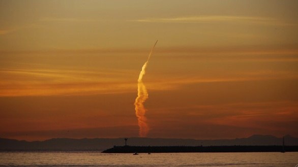
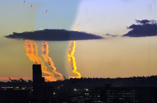
“Missile-like” contrail. Note this is the Dec 31st contrail, not the Nov 8th CBS one. That’s at the bottom of the post.
This kind of contrail confusion is nothing new. This article appeared in The San Mateo Times, Jan 12, 1950:
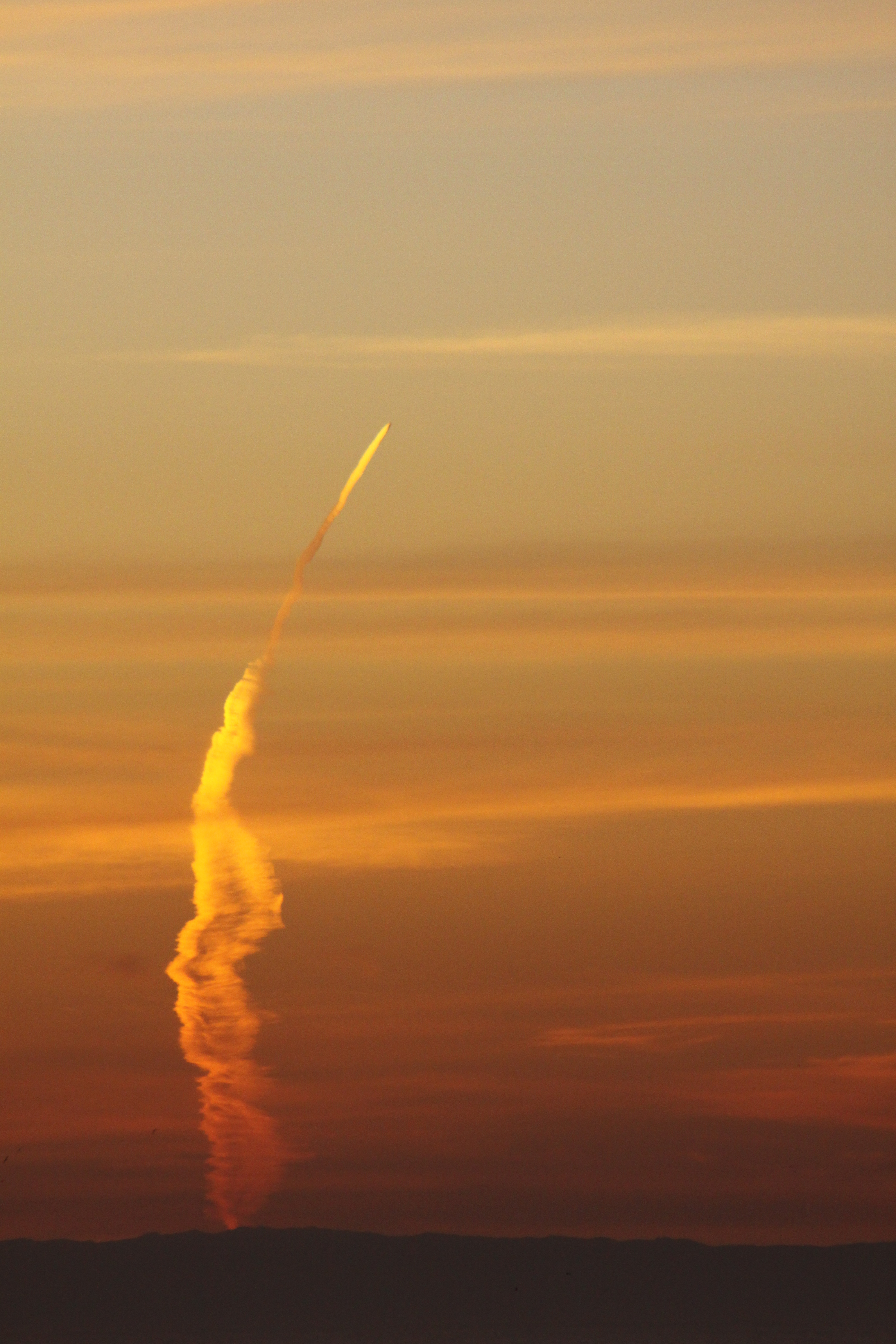
-20101110-073226.jpg)
Here’s some more shots of the same contrail. Click these for larger images:

The idea that it’s a missile launch comes from three misconceptions. Firstly that the trail is vertical – it’s not, it’s a horizontal trail, at around 32,000 feet (about six miles). It’s the same as this:
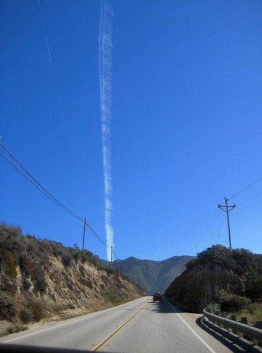
This contrail is no more vertical than the road is, and nor are the power lines at 45 degrees. Everything is horizontal – it’s the just the angle you are viewing it from. All of these show horizontal contrails.
Secondly, there’s the misconception of direction, that it’s flying away from the viewer when it’s actually flying towards the viewer. This is because the “base” of the contrail seems wider than the tip. Perspective tells the brain that this means the base is closer. But actually, you can see the base has been greatly spread by the wind. Since it’s so far away the effects of perspective are greatly diminished, meaning the actual width of the contrail is what is creating the illusion. Imagine if a plane with a 100 mile long spreading contrail were coming towards you; what would it look like? It would look exactly like this.
Thirdly there’s the idea that it goes all the way down to the ground. Now that might be true if the Earth was flat, but the Earth is round, and things go beneath the horizon eventually, no matter how high they are. A plane 200 miles away but five miles up is always below the horizon. If the horizon is raised (as it is here, with Catalina Island), then the distance is less. Here’s some math:
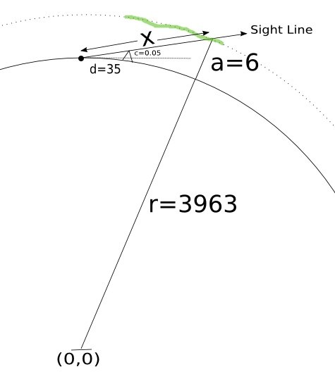
This diagram is not to scale, but the math is the same regardless. The solid curved line is the surface of the earth. The dot at the top is San Clemente. The little triangle is Catalina. “d” is the distance to Catalina (d=35 miles). “c” the amount of Catalina that is visible above the horizon (c=0.05 miles, really a bit more, but let’s be conservative). “a” is the altitude of the plane, (a = 6 miles). “r” is the radius of the earth (r=3963 miles).
The green wavy line is the contrail. Notice it’s at a fixed height above the surface of the earth and is going directly towards the OC.
The point labeled (0,0) is the center of the earth. (0,0) means X=0, Y=0, where X is horizontal and Y is vertical. What we want to know is how far away the plane is, the value x. We do this with cartesian geometry, noting that the lowest visible point of the trail is at the intersection of the dotted line, which is a circle of radius (r+a), hence the equation x^2 + y^2 = (r+a)^2 and the line labeled “sight line”, which has the equation y=r+x*c/d. Combining these equations to solve for x yields a quadratic equation, which we can solve with Wolfram Alpha:
intersection of (y=r+x*c/d) and (x^2+y^2 = (r+a)^2)
and with the real numbers:
intersection of (y=r+x*c/d) and (x^2+y^2 = (r+a)^2) where a=6 and d=35 and c=0.05 and r=3963
Which gives x = 212, meaning that the bottom of the contrail is around 200 miles away. So if the front of the contrail (the actual aircraft) is somewhere above and behind Catalina, then that means the contrail is over 100 miles long. At 500 mph, that means it could have formed in 12-15 minutes, which seems consistent with the descriptions in the discussion above. (feel free to play around with the numbers there to see the effect of various assumptions)
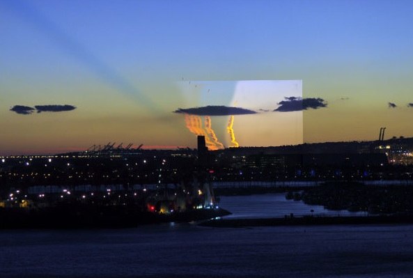
Looking at the satellite image for noon on that day (12/31/2009) and the next day (1/1/2010), we see contrails in approximately the same position, and around 100 miles long, showing it’s quite possible, given the right weather.
Really what makes this odd looking is the position of the people taking the photo. Obviously the same contrail would be visible all the way up the coast, however, the only people who thought it was really odd were those who were lined up with it, in OC. People in LA would see a dramatic looking contrail, but more obviously just a contrail, so less worthy of writing to the newspaper about. I actually saw it myself, but was in a car, and could only get a poor cell-phone snapshot:
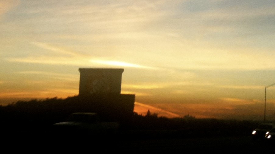
A cell-phone photo I took of the New Year Eve contrail, from an angle that shows it’s just a jet contrail
That was from somewhere around San Diamas, on the 210 freeway, so I’m looking South West, probably around 45 degrees, at the contrail, which you can only see a bit of behind the Home Depot sign. It looked quite impressive at the time. But there are other photos of it from various other angles which show it’s contrail-ness more clearly, here’s one taken from Santa Monica (click photo for original):
The actual New Years Eve contrail, viewed from Santa Monica. This is what the CBS “missile” contrail would have looked like to most people in LA, which is why nobody reported it.
You can see from this angle (and taken a bit earlier) it looks far less interesting, as it’s very apparent it’s just a contrail.
Scott Methvin sent in these two images which shows the contrail in all it’s missile-like glory but from a better angle.

The Dec 31st contrail, from Laguna Beach

Same contrail slightly later.
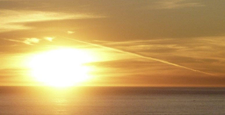
Here’s another angle of the New Year’s Eve contrail, this view is from Corona del Mar, about 20 miles Northeast of San Clemente:
Another angle on the New Years Eve contrail. See, it’s all about perspective.
Here’s a similar photo (of a different contrail, obviously) on the same day at the other side of the country:
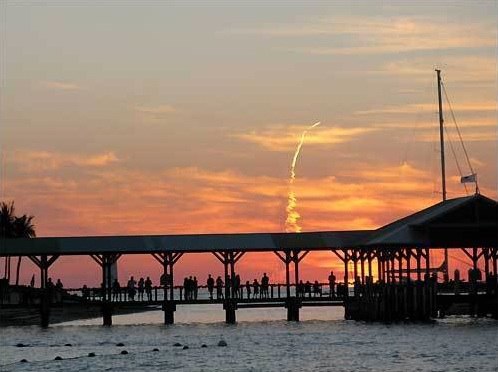
Not a missile launch.
Here’s some more contrails at sunset (From a very nice set of contrail photos), note how they look exactly the same as sections of the New Year contrail:
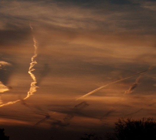
Obviously not missiles. But look at sections of the trails.
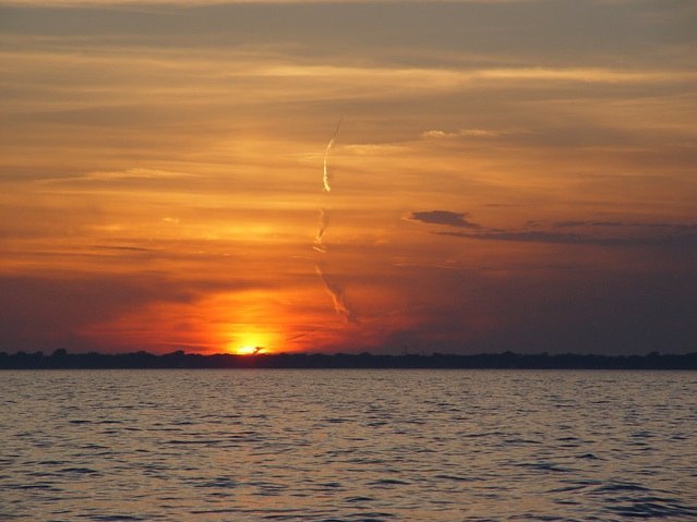
Not a missile launch, in Michigan.
[Update Nov 9 2010]
Now here’s the one everyone is actually talking about. From Monday, Nov 8th, 2010, this time it video taken a local CBS news crew in a helicopter, so they were able to zoom in.

Jet contrail, misidentified as a missile launch, again.
Note it’s pretty much in the same location. Note also it’s not exactly moving at missile speed. Note also it’s practically identical to the photos of plane contrails, above.

Same as last time, maybe even the same scheduled flight.
And once again millions of people failed to notice, because from any other angle it looked like what it was, a contrail, from a plane. Must be a slow news day, as this went all the way up to Jim Miklaszewski asking people at the pentagon about it.
There are occasional flashes of light, which I think are reflections of the sun off a flat surface on the plane. There’s also portions of the video where a bit of the trail behind the plane seems to glow. I think thats just the last rays of the setting sun lighting that portion of the trail. See Scott Methvin’s photos, above for how the trail can be oddly lit from minute to minute.
Here’s a better video. You can see after about 0:50 it’s out of the contrail-persisting region of air and is just leaving a short contrail. It’s also now out of the sun. It looks exactly like the short contrails of a jet coming towards the camera with perspective foreshortening. The camera crew lost it in the darkness shortly after that.
The most likely flight initially seemed to be US Airways flight 808 from Hawaii to Phoenix. But UPS flight 902 was also on a similar track.
http://flightaware.com/live/flight/AWE808

US Airways flight 808, at around 5PM PST (Sunset)
I snapped the above web image at around 5:05PM today, about the same time as the video was taken yesterday.
Here’s the actual track from the 8th:
http://flightaware.com/live/flight/AWE808/history/20101108/1955Z/PHNL/KPHX
And here’s a photo I took (Nov 9th) two minutes earlier from Santa Monica. I think it’s the same flight, just 24 hours later. Note that the angle is exactly the same as the Dec 31st contrail that produced the original “missile” story.

Contrail from flight 808 (verified with Google Earth and radar data). View from Santa Monica, 5:01PM
Obviously, the video would have to have been taken from way off to the right in this photo (I’m looking South West). The chopper would have been somewhere like Torrance.
[Update again]
http://latimesblogs.latimes.com/lanow/2010/11/cameraman-who-filmed-mystery-missile-describes-spectacular-sight.html
The cameraman reports:
Cameraman Gil Leyvas shot video of a luminous point hurtling through the sky followed by a long vapor trail. He said he was aboard the television station’s helicopter shooting footage of the sunset over the ocean about 5:15 p.m when he noticed the spiral-shaped vapor trail and zoomed in to get a better look.
The onboard camera showed a plume twisting up from the horizon and narrowing as it climbed into the sky near Catalina Island, about 35 miles west of Los Angeles, he said.
“Whatever it was, it was spinning up into the sky kind of like a spiral,” and was easy to distinguish from condensation trails from jets, he said. “It was quite a sight to see. It was spectacular.”
I suspect what he saw (which can only be what is on the video, I’d like to see it in HD) is the twisting of the contrails, this can be quite dramatic, especially from such a head-on angle. See this video of a similar perspective, and note the swirling twists in the contrails directly behind the jet.
http://www.youtube.com/watch?v=xl6iR7w7a_Q
Here’s a grab from that video, showing the twist, and how it as accented by the low sun.

Twisting contrails in low sun.
Liem Bahneman gives this excellent description of how flight AWE808 exactly matches the observations, including producing a near identical contrail the next day (which I also photographed, from Santa Monica, above)

This pretty much explains it.
And here are some excellent points from a real rocket scientist, posting as “Michael”:
I’d like to add to all the evidence above that it was just a jet because the plume is nothing like a rocket plume to the trained eye. I was a rocket safety inspector for 3 years, have seen countless launches and failures, and have a master’s degree in Astronautical Engineering. Here’s why it’s not a rocket:
It’s too slow (<— biggest reason).
There’s no engine flare.
There’s no expansion of the plume (as the chamber pressure exceeds the atmospheric pressure more and more during flight).
There’s no staging event.
There are no sunset striations across the plume (which would look like this: http://tinyurl.com/2vklwu5).
In the wide shot, there are two contrails (off each wing!) instead of one.
The plume at the plane is twirling in different directions (very un-rocket-like).
The plume at the plane is twirling too much — that only happens in the case of a motor burn-through, which is a failure mode, meaning it would be seconds from exploding if it were a rocket.
The wind-blown plume is all wrong, vertical plumes go through several different wind shear layers, which makes it look very different than what the video shows.
The apparent direction of the jet is a bit of an illusion, as the trail is greatly distorted by the winds at altitude, which can also vary greatly from place to place. At 37,000 feet the wind can easily be in the 50-100 mph range.
Richard Warren of Long Beach shot four close-up photos of the trail from a fixed position in Long Beach. I’ve combined them here into one photo, where you can see the trail move with the wind, and the actual path that the plane takes is much more obviously passing to the south of Long Beach, matching flight 808.
And the fact that it’s a plane is way more apparent once it stops making a contrail (which is due to it moving between two regions of air – it’s colder and/or more humid out to sea than inland)
Richard took a fifth shot at a wider angle that shows the greater context. The jet is still visible as a dark speck (it’s still got a very short contrail). There’s also a very impressive crepuscular “edge” shadow that’s probably cast by part of the contrail that is over the horizon.
A couple of days later a new photo of the trail was discovered from a known time, heading and position, this allowed the location of the trail to be triangulated, and it became apparent that UPS902 was a better fit than AWE808. This video shows how the UPS trail fits with the picture above:
The UPS flight is also a better fit as it has three engines (MD-11) and hence gives a more solid contrail.
Ah, Uncinus, you’ve caught me on the hop!
Perhaps I’m lucky you did, because you have certainly addressed this badly-understood topic with a greater panache and with better evidence and argument than I would have mustered.
You have made it so much easier for others to understand and for me to explain: I can just direct those describing “steep angles” and “vertical trails” and even “loops” straight to your page here.
It’s true, of course, that non-persistent contrails do this too. It’s just that they have “vanished” before you get to see the complete track of the contrail.
By “vanished” I mean “sublimed back into water vapor”, and we all know water vapor is invisible, don’t we? It hasn’t really gone away: you just can’t see it anymore.
Great disinfo site you have here, I know what I see every day when I look at the horizon, and the Earth is FLAT!
*end sarcasm*
These are some great pictures of beautiful sunsets! I was in San Clemente on the 12/31/2009 and watched the thing through my binoculars and through a Barska 20-60×60 spotter scope and caught about 20 seconds of digiscoped video through the Barska. It was very odd. Check it out at http://www.groovetraveler.com or
http://www.youtube.com/watch?v=88XaLNzysJ0
Hi GrooveTraveler, note that several of the above photos are from the actual incident, and clearly show it to be just a contrail when viewed from a side angle.
Regarding the November 8th 2010 contrail:
What do you make of the CBS Video footage from 42-48 seconds located here:
http://www.cbsnews.com/stories/2010/11/09/national/main7036716.shtml
Specifically the bring light coming from the object?
Upon first glance it looked like the bright exhaust from a missile nozzle, but perhaps it’s just the sun reflecting on the body of the plane?
I think it’s the sun reflecting on the body of the plane. Possible off a window. The sun would have been below the horizon for the cameraman, so the flash looks a bit odd.
Great explanation. I forwarded your link on to friends in the news locally here, so they get the right story out. I can’t believe that it is getting reported STILL this morning, as a mystery launch!
This is all very nice and good however the FAA said there were no high speed flying objects in the air near the missile launch so how do you explain a jet when they said no air traffic??????
I think as more and more people notice the “launches” this will illusion either all be explained or forgotten.
Sorry, but I need to ask the question again since the blog has changed links.
Does NO one know that the US military can track ICBM launches anywhere in the world?
gregg, but “high speed” they mean missile speed. That area is chock full of air traffic every day. I can see it from my window.
I actually video taped this using my canon telephoto zoom 400mm and you can actually see the back of the missile, check it out http://www.youtube.com/watch?v=2vZlkMQ5LuY
I don’t see why some braniac number crunchers haven’t sorted this out yet. If the only possibilities are 1) it’s a jet flying roughly parallel to the earth’s surface or 2) it’s a missile/rocket flying roughly perpendicular to the earth’s surface, it should be relatively easy with the information available to government/military officials.
For one, the dispersion of the trail should give a big clue when considered with the atmospheric conditions and the angles involved. Secondly, as the sun sets, a trail perpendicular to the ground would darken from the bottom up since the rocket would be effectively flying into the sunlight while the sun sets on the bottom part of the trail. That’s completely different to the other option of a plane flying east where it’s trail that’s parallel to the ground would darken from the eastern point to the western (in this case, the top to the bottom) since the plane would be flying out of the sun but leaving the trail behind in the light.
Now get to it, you number crunchers.
How can I send you 2 excellent photos from the launch on 12/31/09-from Laguna Beach. They might change your mind.
I don’t wish to alarm you, @Cindy, but there seems to be a big crack on the back end of that missile. I wouldn’t stand under it if I were you. Or, come to think of it, maybe I would if I were you.
I don’t know why, but think I prefer the cracked and rapidly spoiling craniums spilling their contents into the spillover site forum to predictable soft porn spam.
of course its a simple contrail. The “corkscrew” is the interaction of the contrail with the wing tip vortex. What is truly disturbing is just how many arrogantly ignorant American nob heads are out there. No wonder the country is in deep, deep trouble.
“After lifetime of watching planes leave contrails (like everyone else under the sun). I can tell just watching this contrail being formed that whatever is creating it is cruising really fast and is putting out allot of exhaust- and a very thick/dense exhaust at that.”
—from some brilliant theorist on the spillover site
Interpretation: *Facts? Pshaw! I know more about this than you because I have seen it happen before.*
Much the same response a government inspector who has never actually performed the task you have performing for the past 25 years (ex: farming) without incident, will tell you when he comes out and writes you up for “violations.”
Here is a picture I took of the event. Unfortunately, I only had my wide-angle lens as I was trying to get good sunset photos.
http://flic.kr/p/8SfS7A
To the left, there is the trail of interest…but to the right is at least two similar trails but with different angles. For the record this was taken at Hermosa Beach. Using the clouds for reference, I’m guessing I was south of the NECN coverage. I can’t tell with the Channel 8 video, but it’s interesting that the angle is the opposite…seems that it’s definitely a contrail to me since my pic has the opposite angle as the Channel 8 footage which wouldn’t be possible with a vertical trail.
Anyone can email me photos at [email protected], or upload them somewhere like Flickr and send a link.
Thanks Doug, photos from different angles are key to demonstrating what this is.
I’m willing to bet this is actually AWE26 (USA26) from Kahului to Phoenix:
http://flightaware.com/live/flight/AWE26
http://i.imgur.com/1Du0W.png
The proximity of the plane around 5:00 AM is ideal.
Sounds plausible.
I retract that previous statement. Looks like I got my AM/PM scrambled.
Then I retract the plausibity 🙂 808 still stands.
Here’s my synopsis of the event, with a webcam capture from Newport Beach of _today’s_ AWE808 with a contrail that very closely mimics that of yesterday’s missile/awe808 flight.
http://www.bahneman.com/liem/tmp/it_was_awe808.png
AWE26 is a good candidate, too. According to flightaware, AWE26 was a mere 10 miles ahead of AWE808 on the same heading, both bisecting Catalina Island (808 at 5:01, 26 a few minutes earlier).
Thank you for your excellent coverage of this non-event. The conspiracy kooks are out in full force on this one..
D’oh,h, re: AWE26, me, too on the 12 hours off. It was 12 hours and ten minutes ahead of AWE808 !
If the typos were fixed and if it were edited for clarity, I might be able to make sense of it. “Imagine is a plane”.
In “secondly”, the contrail looks like it is leading away from the viewer. There are a few other perspectives that are described in reverse.
It probably just needs to be rewritten. Three of us read it and can not make sense of the description; though the pictures give clarity.
Excellent. I’ll add that to the post above, thanks!
If you’re willing to kill some time just give this a watch for the time period in question: http://www4.passur.com/sna.html
Excellent little write-up, by the way. You’ve blown the tinfoil right off my head.
Two observations to share. The Nov 8th vapor trail appears to reflect more light of dusk near the horizon than at it’s apparent zenith in the sky. This is consistent with a contrail parallel to Earth’s surface like from commercial aircraft at cruzing altitude (ca. 30,000 ft). If contrail were vertical to surface, the vapor would have reflected more light of dusk high above ground level, i.e., high above the horizon, because of the shadow cast by Earth’s surface at dusk. The vapor trail in question appeared to be darker toward the zenith of the sky (i.e., it was shadowed away from the horizon). I am only left wondering why FAA-klaz issued the NOTAM (notice to airmen) that the airspace in vicinity of US Navy Pt. Mugu-San Nicholas Island test range was closed. Might a commercial pilot in the area at the time read this blog and share observations from their perspective, and comment on the timing and warning of the NOTAM?
Fox News just confirmed from an anonymous source that this was a missile fired by a Sudanese submarine and that [future] President [Jeb] Bush will use this incident as evidence to invade Sudan in January 2012 and give Halliburton a no-bid oil contract.
I misquoted. Future President Jeb Bush will invade Sudan in January 2013, not 2012. My bad.
good job unicus…now where do i buy tinfoil futures ?…
All kidding and prescience aside, the author makes a convincing argument, although there are some suspicions. The author appears to follow the posts closely, going back to the redirected website, but only respond to more of the softball questions. I thought a few of the more direct, sophisticated questions were deliberately ignored, although I found the entire conversation very entertaining. And it was a relatively civilized discussion as well, which was nice.
One assumption being made is that the similar pictures are also contrails rather than chemtrails or missiles. The Pentagon’s statement is also very curious. They are stumped, they have no idea what this was or where it came from, yet they are confirming that there is no threat to national security. The overly curious eventually find themselves on this anonymous blog that provides a plausible, convincing and comforting explanation. Although I’m not a conspiracy theorist, something is not right about this and I’m still asking, “But what if?”
I think providing at least some vague credentials and responding to the more sophisticated devil’s advocates would help the author’s credibility, but my normally non-conspiracy theorist guy is telling me you work for the Pentagon or have some closely vested interest. Amirite?
No, I’m just some guy.
Skeptic, the NOTAM was for the next day.
Unicus, at worst, your blog has comforted a lot of people. You are never going to convince the wingnuts. But, c’mon man, you aren’t just some guy. Perhaps you are an engineer with a passion for photographing contrails and developing a unique scientific niche: proving that missile launches were nothing but airplane contrails. It is an odd hobby to say the least. And oddly convenient. Of course, such governmental tacts would be strictly utilitarian and serve the greater good. And for that I thank you.
You’ve been very polite and gracious for responding to many posts, so I’ll try once again, this time more direct: what do you do for a living? Why are you taking photos of plane contrails to prove they aren’t missiles? That’s not a normal hobby.
after another rum and cola it seems to me…
the most likely reflective surface would be the underside of a wing… not a window…
if there was a lightsource on the object…it would have been seen in all the views , not just one
the reason it didnt show on yesterdays or tomorrows photos …the same reason … the angles are different
still…the most fun i had since election night…
and i still want to buy tinfoil futures
You can see from the 2 photos I sent and which were posted why I thought it was a missile. If it is an illusion it is incredibly convincing. The sun hit the “missille” seconds after the first shot. I have a hard time seeing a jet airliner. Live near John Wayne airport and see them all the time.
Thanks for posting the photos.
It’s amazing, the news reports are all over this story with ABC network making it their lead story. I’ve heard several reports mentioning this website by name as the source for the correct answer to this mystery. Uncinus, you figured this out before the entire command structure of the US military and NORAD. That’s something to be very proud of.
its 11:20 pm here …and the local news is still reporting a missle launch…sigh
am leaving the house now to buy all the available tinfoil…
OK, Unicus doesn’t want to tell us what he does, implying he can’t (or doesn’t want to which would not be rational since credibility here is key and he has proven himself to be more than rational). So let’s review the evidence: Pictures are uploaded from this other recent Dec. 31 contrail event, where Unicus tells us these are also just photos of contrails. We won’t even ask him again why he’s taking these photos and maintaining this website, which are interesting questions in themselves.
Devil’s Advocate: No evidence has been presented that the December 31 event was a contrail. Assuming it was, there is no evidence that the photos are of that event and are not simply photos of a missile launch. Also can’t get over the sophistication of math, science, and interest in flight paths. I’m curious how someone with this technical background would also be a computer software engineer able to upgrade his website relatively easily and, also with remarkable sophistication. Just some guy, eh? I’m just some guy, too. I have no problem telling you what I do. I’m a lawyer and I call bullshit.
My last point regards the “Big Lie Theory” which originated with Nazi Germany. Repeat a big enough lie and people will eventually believe it. The theory goes that no one would ever risk their credibility by telling a big enough lie, therefore it is more than likely true. Here, we have someone going to extraordinary lengths to prove a negative, deliberately evading who he is and what he does. Its the Big Lie Theory, but without risking credibility. I cannot see the Pentagon/military going these lengths to cover an accidental launch. Own up to it and the public is forgiving when no one is hurt. There is something else going on here.
this is interesting, make of it what you will.
40 or 50 miles from catalina island is Point Mugu Naval Air Warfare Center-Weapons Division Sea Range and on october 21 they conducted a test using an experimental laser system to destroy a solid-fuel, short-range ballistic missile while its rocket motors were still thrusting. the missile used was a terrier black brant, a type of sounding rocket. one of the advantages of using sounding rockets in for testing is their smaller size allows them to be fired from a ship. they also have short flight times, usually under 30 minutes.
more info on point mugu naval warfare center – http://www.navair.navy.mil/index.cfm?fuseaction=home.display&key=DF08C85C-6DB0-47AC-89BF-18A1093507F8
point mugu controls a 36,000 mile sea range that includes san nicolas island. here’s a google map of the relation of point mugu, san nicolas island and catatlina island.
http://maps.google.com/maps?f=d&source=s_d&saddr=Catalina+Island&daddr=San+Nicolas+Island,+CA+to:Point+Mugu+Nas%2FNaval+Base+Ventura+Co,+CA&geocode=FW51_QEdShzx-CnNAjms527dgDG0uAeYMf44tg%3BFfRM-wEdX5bg-CmnrHnt0DXmgDECZCl9EuKyAA%3B&hl=en&mra=ls&sll=33.358062,-118.905029&sspn=2.991293,5.817261&ie=UTF8&z=9
press release of the laser test.
Airborne Laser Test Bed Exercise Conducted
10-NEWS-0014
October 21, 2010
The Missile Defense Agency conducted a planned exercise of the Airborne Laser Test Bed (ALTB) this morning (late evening Pacific Daylight Time) at the Point Mugu Naval Air Warfare Center-Weapons Division Sea Range off the central California coast. The objective of this mission was for the ALTB to destroy a solid-fuel, short-range ballistic missile while its rocket motors were still thrusting.
The Terrier Black Brant target missile was launched successfully. Preliminary indications are that the system acquired and tracked the plume (rocket exhaust) of the target, but never transitioned to active tracking. Therefore, the high energy lasing did not occur.
Program officials will conduct an investigation to determine the cause of the transition failure. The intermittent performance of a valve within the laser system is being examined.
MDA Media Contacts:
Debra Christman
San Dawgz – you’re scientific ignorance and general jackassery are giving the rest of us lawyers a bad name. While accurate and competent, Unicus’ “math and science” is not all that sophisticated. Any freshman engineering student (I have an undergrad engineering degree), and probably lots of smart high school seniors, could reproduce what Unicus has done. And “upgrading” a website (presumably you mean “updating”?) is simple. I could teach you (well, maybe not you but someone) how to do it in 45 seconds. Last but not least, maybe Unicus just wants to maintain his privacy so he doesn’t have to worry about lunatic conspiracy nutjobs showing up at his house. In any event, give it a rest. Signed, Just Some Other Guy
Make that “your” not “you’re” – ‘scuse my typo in the previous post.
These demands for definitive statements by the military and author credentials are silly. If military spokespersons had said (or do say tomorrow), “Of course it was an airliner” or if the author said, for instance, “I’m an atmospheric scientist,” would the response from any of the missile enthusiasts be “Oh, well, then, that’s fine. Never mind.” Even one or two of them? Of course it wouldn’t. The response would be more along the lines of “See? They lied just like I knew they would” or “Yeah, fine, a scientist, but tell us, who exactly paid you to say this stuff back at the beginning of the year, knowing they had the secret launch coming up this month?”
The thing you have to understand about conspiracy theorists is this: The vast majority are going to believe what they’re going to believe until the day they die. Present well thought-out arguments and unequivocal physical proof all you want — until you’re blue in the face if you like — and it won’t matter one whit. The entrenchment is especially firm in the minority of people reduced to quivering blobs of jelly at the prospect of terrorism, which they might be doubly horrified to learn is the primary aim of terrorism.
How many lunar landing disbelievers have changed their minds upon seeing the recent photographs of the Apollo landing sites taken by the Lunar Reconnaissance Orbiter? For that matter, how many even looked at them? My guess is very close to zero for both numbers, because, of course, the government fabricated those images or they flew robots up to the moon to plant this evidence to be photographed. If you flew those enthusiasts to the moon and hovered over each of the sites for an hour or so, I’m sure most would prefer to believe later that you had drugged them and implanted false memories because “Total Recall” as scientific fact, not fantasy, is a much more preferable thing to believe as it would lend credence to their theory, not your demonstrable facts.
Once you realize that you cannot and will not be allowed to win the argument (or, in the more extreme cases, even have blatantly obvious facts accepted as such), life becomes more pleasant and you waste a lot less of your time as you learn to simply detour around folks who are at their happiest when they spend hour upon endless hour spinning specious circles around you.
You are calling me names and then saying I’m giving people like you a bad name? Perhaps sophistication was the wrong word. Let’s say his extraordinary effort at proving a negative is suspicious. I asked for as much as a VAGUE description of his job, which he can’t even provide. I don’t need to know his name, although I commented that it would add to his credibility. And when people have weird, niche hobbies, they are usually proud of those hobbies, and do not hide behind pen names, as many of us are doing, including myself. I’m not putting my name out there, but I told you I’m a lawyer. A very vague description of my job, which Uncinus won’t do.
Give it up? I’m still undecided. I haven’t made a determination in my mind whether this is a contrail or a missile, but as a fellow lawyer, I’d hope you’d agree with me that this “evidence” has not laid a foundation. At all. This is witness is not a qualified expert. Unless he can tell us how. His credibility is already shot with me, but I bet you are the lawyer that believes anything a client tells you? You must be if you are so easily convinced. Just some other guy, lol.
And if you are so talented, I can’t help but notice that you only attacked my semantics, not my logic. This website is more than a hobby. I’ll give it a rest if you get a clue. Deal?
Mike, this evidence has no foundation. It could all be a bunch of missile pics for all we know.
I just read a quote that said the Dec 31 incident is “commonly believed” to be a plane contrail. Look, I’m not saying its one or the other. But you can’t base your decision on this blog, which has a curious agenda.
Woot, I win. To celebrate my victory over the people who have to wake up for their government spin jobs tomorrow, I just want to clarify what it means to lay a foundation for evidence. Many people, with their comments above and on the overflow site, laid foundations for their opinions. “I’ve worked on a submarine that launched missiles” or “I’ve lived near a base where they launched missiles and can distinguish between a missile and a plane contrail.”
This author, Uncinus, just posted pics and makes statements like “Obviously a contrail” and “Missile-like contrail.” A judge wouldn’t accept any of this crap. This guy is DEDICATED to proving missile sitings are planes. Goes to extraordinary lengths. And by the way, as I head to bed, an UNEMPLOYED lawyer, if you gov’t types want to hire me to help me with your spin-doctoring, I am for sale. You know where to find me, just don’t come barging in, in the middle of night.
“We won’t even ask him again why he’s taking these photos and maintaining this website, which are interesting questions in themselves.”
Why aren’t people allowed to have hobbies without being the victim of paranoid speculation and assumption?! I’ve always had a love for aviation and can EASILY understand why Uncinus has created this site! He’s trying to be helpful to those who have been fed some very bad info!
“I asked for as much as a VAGUE description of his job, which he can’t even provide. I don’t need to know his name, although I commented that it would add to his credibility.”
So what does this prove?! There is no way you’re a lawyer!~ Well, at least it’s obvious why you’re out of work! I certainly wouldn’t want someone who makes so many assumptions representing ME in a court of law! It’s OBVIOUS that you have already condemned Uncinus just for having a website about the “chemtrail” hoax! Why?! Because he won’t give you his name?! I don’t blame him one bit! These “chemtrail” believers have made numerous threats against those of us who claim the trails in the sky are nothing more than persistent contrails. One would have to be an idiot to give out their name if they aren’t a proponent of the “chemtrail” myth!
I attended a school for commercial aviation in the early 80’s and one of the first things we learned in meteorology is how a contrail is formed in the varying conditions of the atmosphere. It’s simple and basic science. And from what I have seen of the “missile” in the news…it’s WAY too slow to be a missile. As a person who worked on a submarine that fired missiles, I’m surprised that you wouldn’t know that.
“Woot, I win,” said the first person to bring Nazis into the discussion, not really understanding the Interwebs at all.
I think this “missile” story is the best thing that could happen to the chemmies. Now, hopefully, there will be a lot of attention on the trail itself. It’s obviously persistent, the experts are now claiming that it’s a contrail and it’s moving far too slow to be a missile. I’m just hoping that the graphic artists over at the pentagon are drawing up presentations about contrails, jet engines and the science that easily explain how they all interact with each other. I’m keeping my fingers crossed that there is actually enough continued interest in this one event that someone will make it their life’s work to explain this horrible hoax.
I feel terrible for the lives that this cult has ruined! Well, “ruined” may be a bit of an exaggeration. They don’t seem to be all that bothered by the whole “chemtrail” thing…they go on with their lives…doing nothing about it other than whining with each other on youtube, and other sites. Making baseless accusations about people they don’t even know, all in the name of government hatred. These people deserve the pity I feel for them!
If I thought, for a second, that I was being sprayed like a bug by my own people, I’d be camped out somewhere with signs and a bullhorn.
Everyone keep your fingers crossed…I expect some good explanations on how contrails are created to be posted in all forms of media today! Please post links to anything you find. Thanks
When I read the baseless accusations about uncinus, I can almost understand what they “believe” him to be. He’s a shadowy figure who is paid to run a disinformation site from his Smokey-glass-walled ultra sophisticated evil office space.
I see a different kind of scenario because I’m not paranoid.
I see a very well educated gentleman, perhaps a head of a corporation…upper management anyway…who has been educated in aviation as a private pilot. Successful corporate types are often pilots, and many of them have homes/events around the country that they can fly to. I KNOW he’s done his homework.
This site is NOT the obsession so many think it is. He does 5 minutes of maintenance…reads a few posts….goes about his day. Just as I do. I get accused of spending too much time on this site also, but I assure you that I have a very physical job and I’m on the move all the time. I do have access to a web browser wherever I am though. This site is always a tab away.
Why do I automatically assume that he’s NOT a shadowy government paid figure?! Am I that out of touch with reality, maybe. I have to see some compelling evidence before I change my mind.
sigh
its not about the ‘trails , its about the flickers of ‘ flame ‘
lots of things leave trails
not many of them also have flames
and just cause there are flames…dont mean you need a tinfoil hat
Flame? I saw no such thing in the sources I’ve see. Are you sure you’re not mistaking some natural light trickery with something else. That’s not rhetorical, are you SURE!? Maybe I have missed something in my “research”. I’ll watch the video again.
For the “missile” believers, I’d just like to redraw your attention to the post by Liem Bahneman. He used a Newport Beach webcam, 24 hours after the first contrail, and the shot shows an identical shaped contrail in the same position.
http://blog.bahneman.com/content/it-was-us-airways-flight-808
Depending on the weather, it’s quite possible that AWE808 will leave the same contrail again. Perhaps CBS could send their chopper up around 5-5:50 today?
why is it so hard to believe that this is a rocket and ,covered up by military as usual ,,why do people who pretend to do scientific research help them to ..even contrails are not filled with barium,aluminium.phosphor ,in your opinion ,,while other reasearchers have proven it to be so.
where is the world going if science is politicaly abused and not the truth
are you being payed to spin these matters and deflect the peoples attention
To answer your question, bassax: Science is filled with unknowable black magic and confusing multisyllabic mumbo-jumbo, and it’s far too mysterious for the average human mind to comprehend. Therefore, everybody should give up trying and simply believe what they want. You have to admit, that methodology (sorry about the syllables) seems to work pretty well for quite a lot of people.
“why is it so hard to believe that this is a rocket and ,covered up by military as usual ”
Lack of evidence.
“even contrails are not filled with barium,aluminium.phosphor ,in your opinion ,,while other reasearchers have proven it to be so.”
“proven”?! I disagree. I have yet to see ANY evidence that says any such thing. I have seen many reports of such things, but it always seems to based on assumption and not on physical evidence. If I’m missing something, please provide a link. Thanks
“are you being payed to spin these matters and deflect the peoples attention”
And there it is…the speculation that gets so many into trouble.
What a shame.
http://www.cnn.com/video/#/video/bestoftv/2010/11/10/exp.nr.mystery.launch.explained.cnn?hpt=C2
Hey Man.
It just airplane.
look at this:
http://www.youtube.com/watch?v=9sVmjpDZLN0
I love you~~ thanks~~
It’s stories like these that really make the scientifically illiterate people of the world stand out. They desperately hope and pray that there’s some big Government cover up, and refuse to take into consideration the only source of actual “evidence” that has been presented (contrail).
Just like “chemtrails”.
Just like religion.
Just like homeopathy.
Just like anti-vaxxers.
adnauseum
Looking at the videos, it appears to me that the object is gaining altitude rapidly. Plus, jets don’t commonly produce contrails of that thickness.
I’d like to address the subject of conspiracy theories. Bear in mind that I’m changing the subject slightly, and nothing that follows is intended to directly address the substance of this “contrail vs. missile” incident.
Something interesting I realized not long back, on the subject of “conspiracy” theories:
First, we’re all human. There aren’t any vast cool intellects out there thinking in ways that none of us can understand. We saw the perfect example during the Bush administration: The President of the United States was for 8 years a slightly-below-average man who could barely string together full sentences.
Second, if I can come up with a conspiracy, and if you can come up with a conspiracy, anybody can come up with a conspiracy. A conspiracy, after all, is just some little finagle of the law or common ethical behavior that two or more people agree to participate in.
Third, people in positions of power – those ordinary, sometimes stupid yutzes just like you and me – are different in two main ways: One, they probably have ambition at levels you and I don’t normally see – what amounts to ruthlessness. Two, they have the power to make big things happen.
And fourth, the proof is all around us that the bigger you get, the more chance you have to shed the morality that your ordinary man on the street has. I don’t watch my feet when I walk to keep from stepping on bugs, and neither do they; it’s just that their “bugs” are people like you and I. (And if you don’t think there are people out there – within a 10-minute drive of your house – who consider you no more important than an insect, I’m not sure what planet you come from, but it isn’t this one.)
Put this all together, and it’s obvious that conspiracies DO happen. They happen on the small scale at which you and I live our lives, and they happen on the large scale at which “big people” operate. Today your friend the supermarket cashier winks and tosses a $12 steak in your bag without ringing it up. Tomorrow the leader of North Korea launches a missile so your company’s $50 billion defense contract gets approved by the U.S. Congress. The next day, the leader of a powerful country launches an attack that eventually kills, maims and leaves homeless hundreds of thousands of faceless strangers in a distant place, and not one person in any position of power loses sleep over it.
Back to Bush again: There actually was a “vast right-wing conspiracy” that played out in full public view – the conspiracy of the GOP, the Democrats, and the entire massed might of American media to keep quiet about how stupid George W. really was – and THEY GOT AWAY WITH IT. Not one public figure ever challenged Bush over anything. And they never will.
On a smaller, day-to-day scale, I’d bet every one of us has seen video of cops shooting or beating people without cause. How many of those cops go to jail, or are even openly criticized? It’s pretty close to zero. We have an open conspiracy that police officers should never get convicted … and almost never even be fired. There are even a few possibly-good reasons why this should be so, but it’s definitely a conspiracy, and cops definitely do get off with light or no punishment, no matter what they do.
(Just as an example: A local cop where I used to live slammed into another car and died after a night of heavy drinking. No blood alcohol test was ever performed, no mention was made of the fact that he wasn’t wearing a seat belt – I heard it because I knew people who worked for the newspaper – and he ended up getting a hero’s funeral, with every local official in attendance, as if he’d died saving orphans from a drug-war shootout.)
The point is, conspiracies really happen, and probably more often than any of us guess. During the Watergate debacle that brought down Nixon, someone asked when the people involved got together to discuss the cover-up. The answer was something like “Actually, nobody ever suggested there WOULDN’T be a cover-up.”
Nothing I’ve said here is meant to imply that I think any particular conspiracy theory is based in fact and worth seriously considering. We DO have crackpots among us.
What I am saying is that no particular wild idea or conspiracy theory is automatically laughable. We also DO have people in positions of power who have little or nothing like what you and I would consider common moral judgment.
Those who laugh at the idea, who automatically refuse to believe large-scale conspiracies exist, are really practicing a sort of reverse religion – rather than believing that a god exists despite the lack of evidence, they believe that conspiracies do NOT exist, no matter what sort of evidence turns up for them.
Bassax wrote:
“even contrails are not filled with barium,aluminium.phosphor ,in your opinion ,,while other reasearchers have proven it to be so.”
This is simply a false statement.
Not a single contrail has been sampled directly- IN SITU- and proven to contain the aforementioned ingredients…not one.
Taking a sample of something on the ground and claiming definitively that it is from a contrail is not a scientifically valid conclusion.
Just saying…
http://www.youtube.com/watch?v=9sVmjpDZLN0
Yes, It is airplane. Thanx~~~
Hank wrote:
“it appears to me that the object is gaining altitude rapidly.”
yes- thats the whole point…how perspective is a funny thing.
if that were the case, however, then the highest point of the trail would be the brightest- catching the most light…
when in actuality it is the seemingly lowest part of the trail that is brightest due to it being further away on the horizon still catching the setting sun…
…and jet makes contrails of that size often…just look at all the pictures on this site dating back 60yrs…
SR1419: Ahem. Word-wise, that initial assertion was just about 3 percent of my comment, which was mostly about something else entirely.
Why would the government want to cover these two very similar incidents up if it was an accidental missile launch? AND claim that they have no idea what it is? They know what it is. What have they been covering up for years?
My theory is that these are USO’s. If you read any information on them, there are supposedly “bases” in the exact locations these “missiles” were launched from. From the videos and pictures, these look more like a rocket to me. Why else would the government be playing “stupid”? Well….then again.
Suntour, heh.
Are you saying there AREN’T “big government cover-ups”? Or big corporate conspiracies? Hell, I could probably name a half dozen without even googling. Everything from the value of diamonds to the hazards of marijuana, from toxic waste dumped into lakes and rivers to the safety of tobacco products.
Hell, just the idea that individual air travelers should be relentlessly probed at security checkpoints, while container freight big enough to contain nuclear weapons, poison gas, biological agents, gets shipped into the US virtually without inspection — doesn’t that seem something of a conspiracy to keep people stupid, and busy, so that they don’t panic at the reality of the situation?
Hank said : “that initial assertion was just about 3 percent of my comment”
indeed…but it IS what the entire topic of this article is about and the impetus for the discussion at all…but whatever..
As for the rest of your comment….you are entitled to your opinion.
http://www.cnn.com/video/#/video/us/2010/11/10/nr.missile.not.a.plane.cnn?hpt=C2
Both “sides” make good arguments at this point, with one exception; the definite appearance of a rocket’s exhaust. Since the sun is setting in the west, how would that allow for a mere reflection? One more issue that I can’t ignore is that the video shows an object moving much faster than an aircraft would appear to accelerate at FL35. Plus, as you all know, when looking at a departing object, along a horizontal departure, the perception of speed is skewed to appear slower than actual. It just doesn’t add up. Face it, it is a devastating blow for the current administration if this were a military accident, or if this is an unscheduled missile launch, regardless of who launched the missile. They’re screwed, so they lied… unfortunately, that seems plausible.
NetGear,
I see your points. Where did this “missile” go?
The Pacific Ocean…
That is a lot more believable than the “plane” theory.
By the way, that’s actually a great question… where did “it” go. If it were an aircraft, the FAA tracks all flights through “airways,” ironically in an effort to make sure all flights, military and non-military maintain good separation. This “mystery” is over if they just identify the craft. Why lie? Why drag their feet? No need for a mystery.
a potential flight HAS been identified several times…even so far as to go back the next day for a similar contrail at the same time…perhaps you should reread the article at the top?
Here is the possible flight:
http://flightaware.com/live/flight/AWE808/history/20101108/1955Z/PHNL/KPHX
That doesn’t answer all my questions, perhaps you need to re-read my posts.
Yes, SR1419, I saw that. I don’t believe that it was an airplane. A “potential” flight, they don’t know for sure? The FAA does not know for sure? They are going to let it rest at that and we will all forget about it until the next incident occurs.
All of these people convinced that this is something that came out of the water make me wonder what they think something actually coming over the horizon looks like from a great distance. Do they, perhaps forgetting that the earth is curved, believe it suddenly appears out of nowhere as a tiny dot way well above the horizon? I think that’s the only alternative available to them.
If that’s the case, I’ve a feeling that now is probably the best time in decades for the Flat Earth Society to fire up a new membership drive. I will expect a 10% commission for this idea. Call me — I have an excellent idea for a two-dimensional Society baseball cap.
The FAA does know for sure that they did not track ANY unusual movements on their radar:
“The FAA ran radar replays of a large area west of Los Angeles based on media reports of the location of a possible missile launch around 5pm Monday. The radar replayed did not reveal any fast moving unidentified targets in that area. The FAA also did not receive reports of any unusual sightings from pilots who were flying in the area Monday afternoon. Finally the FAA did not approve any commercial space launches around the area Monday.”
http://losangeles.cbslocal.com/2010/11/09/pentagon-cant-explain-missile-off-california/
They did, however, track flt AEW808- flying the exact direction at the approximate time of the sighting…and since we know that contrails often persist and spread…and the problem of perspective is an understood phenomenon…its very likely just an airplane…
SR1419, heh. You know, if you’re arguing with people prone to suspect government cover-ups, citing statements by a government agency isn’t exactly the ultimate trump card argument.
NetGear: “it is a devastating blow for the current administration”
Not really.
Given the “missile launched from a sub” scenario, which is more likely?
A) The missile was launched deliberately.
B) A massively fail-safed system failed and a missile just sort of fired itself.
Knowing nothing at all about it, I still find it hard to imagine that an ICBM can just “go off” like a dropped Saturday Night Special.
If you buy into the scenario at all, it was likely a deliberate launch, with some definite purpose in mind.
Like, say, Dr. Evil demonstrating that he can subvert the launch systems of nuclear-armed U.S. submarines, so world leaders will pay him ONE … MILLION … DOLLARS!!
I mean, throw me a frickin’ bone here, Scott.
Nah, no conspiracy. Stop the childish innuendo. I just don’t believe there’s been a good explanation; on this site or from anyone else for that matter. I’ve now listened to those from MIT (who says it’s a missile) to so-called contrail experts (who disagree). It’s only a mystery because there’s been no reasonable explanation.
By the way, if anyone cares what I think… I will not be surprised if someone screwed up at the Vandenberg scheduling office, and it was a private launch. Granted, that plume seemed a good bit larger than anything I’ve seen from a private org. Plus, you would think there would be some PR associated with that type of launch. Maybe someone will get a conscience and spill the beans, one way or the other.
NetGear, I was joking.
What’s funny is these people who insist, with all the sly sneering of the sane for the crazy, that it could not possibly, no way no how, have been a missile, and that government representatives would never lie, because “Why should they?”
Gah. It’s like they grew up on some other world. They’re like teenagers who think they know everything.
And SR1419, before you get all exasperated, I’m not saying I’m certain it was a missile. Just that it looked like one to me, and that all this stuff about perspective and such is unconvincing in the face of the actual images.
Apparently, also, I lack the full faith you seem to have that it is impossible for officials to lie, and you lack both the ability to imagine reasons why they might, and the memory that they sometimes actually DO.
SR1419, thanks for the link/info. So, is AEW808 an Aerosvit Airlines flight? They only fly out of NYC, so that call doesn’t make sense. Or do you mean Airborne Early Warning?
Oops. Missed that, Hank. Thanks for clearing that up.
Hank….
Why would you make assumptions about what I have the ability to do, know or not- you should know better than that.
You know NOTHING about my beliefs regarding “officials” and their ability to lie or not…
…and yet, I am unaware of any “official” saying it was a contrail- pundits on TV/Blogs etc…are not officials…
As far as perspective go- one thing to consider….
If it was a “missile” on a vertical trajectory, the light on the plume would be brightest at the top- as the higher it goes the more sunlight it would catch…
yet the opposite is true…it is brightest at the “bottom” and seemingly darker at the “top”- which would indicate a horizontal trajectory…as the “top” would be furthest from the setting sun and the “bottom” would be closest- ie; further West…
…and a horizontal trajectory supports the contrail theory.
sorry- its US Airways flight 808 (AWE808).
http://flightaware.com/live/flight/AWE808/history/20101108/1955Z/PHNL/KPHX
Everyone is entitled to their opinion and what some may refer to as “conspiracy theories” are just common sense. The government relies on people like these to discount “conspiracy theories” when lies have been proven over and over again. I appreciate the thoughts of those who consider the options because NONE of us REALLY know what it was and may never know.
SR1419, I’m not making assumptions. I’m observing what you’re actually saying, the way you’re actually acting.
” … the light on the plume would be brightest at the top- as the higher it goes the more sunlight it would catch …”
… unless that topmost plume was in shadow. Which, given the fact that it’s sunset, and that we already see scattered cloud bands, is possible. A low bank of clouds on the horizon could easily produce this effect, with clear sky at the bottom letting sunlight through to illuminate only the lower part of the vapor trail.
Hank said: “I’m observing what you’re actually saying”
really? please point out where I said “it is impossible for officials to lie”
…and when you can’t…
as for your cloud band…thats possible but as someone put it- thats “unconvincing in the face of the actual images.”
REally?? wrote:
“I appreciate the thoughts of those who consider the options because NONE of us REALLY know what it was and may never know.”
Yes we do.
It was a commercial flight coming up over the horizon, with its contrail foreshortened by the direction being more-or-less directly towards the camera.
We know that is exactly what is was.
To pretend anything else is to perpetrate a hoax. So what is your purpose for continuing to put forth this hoax?
SR1419 said: “please point out where I said ‘it is impossible for officials to lie’
I said: “I lack the full faith you seem to have …” Seem. Seem, seem SEEM.
Seem: To give the impression of.
Christ, stop being a dick. I get it that you have some ardent reason for this not being a missile. And in the face of considerable uncertainty surrounding the situation, I admit you may even be right.
The problem is, you SEEM less willing to allow others that same possibility. Your stick-up-the-ass “you are entitled to your opinion” is hardly the generous inclusive statement that would bring friendly closure to the issue.
To me, it looks like a missile. To me, you seem unnecessarily convinced of your rightness.
Local NBC affiliate news just said Pentagon says airplane, then the national NBC news leads with Military still mum. Funny stuff. Netgear says: “Looks like a missile to me…” That plume looks like solid rocket fuel burn. No optical illusion. Guess only God knows the truth, well, and a few guys in NORAD and the WH. HAGO.
MikeC: “To pretend anything else is to perpetrate a hoax. So what is your purpose for continuing to put forth this hoax?”
Mikey, I’m gonna come right out and say this: What are you, like 15 years old? You sound kinda stupid, kiddo, and kinda on the mean side of stupid.
To express doubt about the explanation of a certain phenomenon is not to “perpetrate a hoax.” In my case, it’s to point out that there is still some reasonable possibility of other explanations.
Sorry, but no, we don’t “know” that a commercial flight is “exactly” what it was. There may be a fair-to-middlin’ probability that that’s what it was. That doesn’t amount to “exactly.”
This is a quote from a fictional character I came across recently, but it still rings true, and seems appropriate here: “When have you ever known anybody who had no doubts that was right about anything?”
Ok Hank…wanna get literal?…you also said:
“you lack both the ability to imagine reasons why they might, and the memory that they sometimes actually DO.”
really? fascinating…and i’m the one being a dick?…classic.
your ad hominem attacks truly add nothing of value to conversation.
Your opinion to which I referred was regarding a long-winded treatise on conspiracies…
I commented on your initial assertion because it seemed like a cursory opinion that didn’t take into account the evidence that suggests many people make that interpretive mistake when looking at some contrails…that and the fact that jets “commonly” DO make contrails that look just like that.
Again with the assumptions…I have no reason- ardent or not- for this not to be a missile.
I just do not think it is.
I am entitled to my opinion