UPDATE – After getting a new photo of the trail, Liam Bahneman told me he was now siding with it being his second choice, UPS902. Having reviewed the evidence, I fully agree that UPS902 is a much better fit than AWE808, especially when viewed against the composite photo.

UPS902 Turns out to be a much better fit
Note to everyone else – If you have photos of the Nov 8 contrail from any angle, please email them to [email protected]
[This post was originally from Jan 19th, 2010. I’ve updated it with information about the “Mystery Missile” contrail of Nov 8, 2010, at the bottom of this post. Clearly, it’s the same thing]
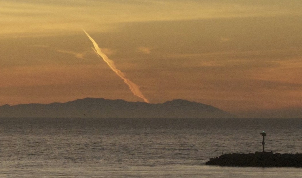
An interesting contrail cropped up off the coast of San Clemente, Orange County, California on December 31st, 2009. The curious shape led some people to think it’s a missile launch, which it does kind of look like (all taken from San Clemente)
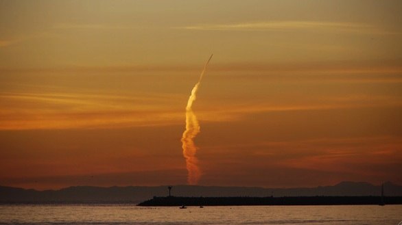
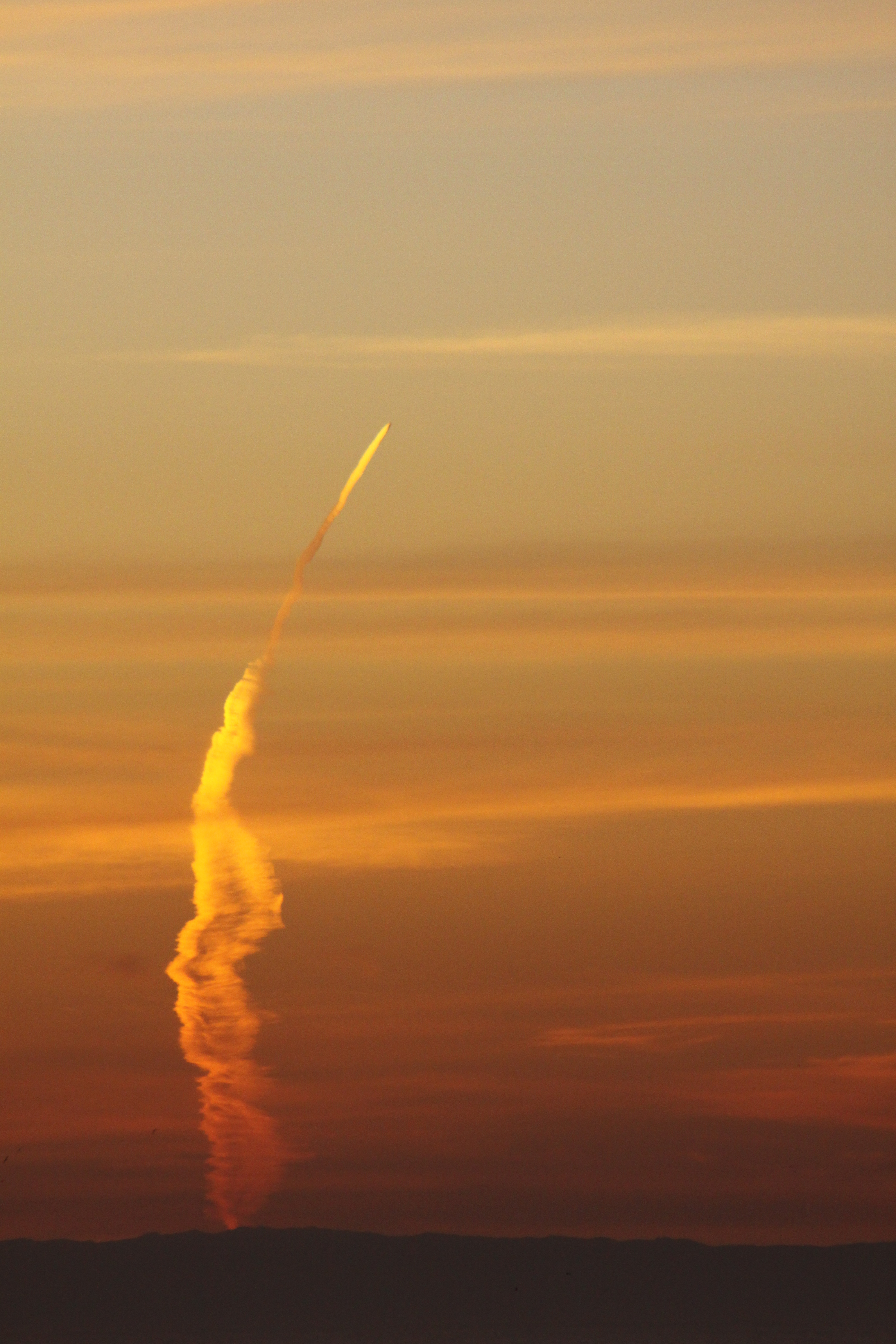
“Missile-like” contrail. Note this is the Dec 31st contrail, not the Nov 8th CBS one. That’s at the bottom of the post.
This kind of contrail confusion is nothing new. This article appeared in The San Mateo Times, Jan 12, 1950:
-20101110-073226.jpg)
Here’s some more shots of the same contrail. Click these for larger images:

The idea that it’s a missile launch comes from three misconceptions. Firstly that the trail is vertical – it’s not, it’s a horizontal trail, at around 32,000 feet (about six miles). It’s the same as this:
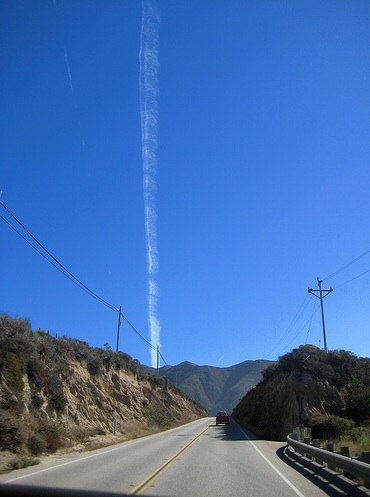
This contrail is no more vertical than the road is, and nor are the power lines at 45 degrees. Everything is horizontal – it’s the just the angle you are viewing it from. All of these show horizontal contrails.
Secondly, there’s the misconception of direction, that it’s flying away from the viewer when it’s actually flying towards the viewer. This is because the “base” of the contrail seems wider than the tip. Perspective tells the brain that this means the base is closer. But actually, you can see the base has been greatly spread by the wind. Since it’s so far away the effects of perspective are greatly diminished, meaning the actual width of the contrail is what is creating the illusion. Imagine if a plane with a 100 mile long spreading contrail were coming towards you; what would it look like? It would look exactly like this.
Thirdly there’s the idea that it goes all the way down to the ground. Now that might be true if the Earth was flat, but the Earth is round, and things go beneath the horizon eventually, no matter how high they are. A plane 200 miles away but five miles up is always below the horizon. If the horizon is raised (as it is here, with Catalina Island), then the distance is less. Here’s some math:
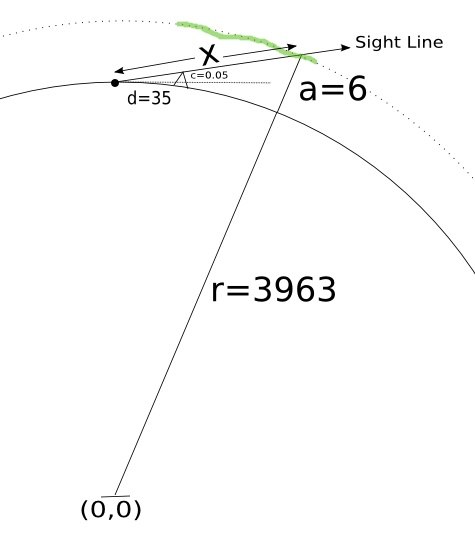
This diagram is not to scale, but the math is the same regardless. The solid curved line is the surface of the earth. The dot at the top is San Clemente. The little triangle is Catalina. “d” is the distance to Catalina (d=35 miles). “c” the amount of Catalina that is visible above the horizon (c=0.05 miles, really a bit more, but let’s be conservative). “a” is the altitude of the plane, (a = 6 miles). “r” is the radius of the earth (r=3963 miles).
The green wavy line is the contrail. Notice it’s at a fixed height above the surface of the earth and is going directly towards the OC.
The point labeled (0,0) is the center of the earth. (0,0) means X=0, Y=0, where X is horizontal and Y is vertical. What we want to know is how far away the plane is, the value x. We do this with cartesian geometry, noting that the lowest visible point of the trail is at the intersection of the dotted line, which is a circle of radius (r+a), hence the equation x^2 + y^2 = (r+a)^2 and the line labeled “sight line”, which has the equation y=r+x*c/d. Combining these equations to solve for x yields a quadratic equation, which we can solve with Wolfram Alpha:
intersection of (y=r+x*c/d) and (x^2+y^2 = (r+a)^2)
and with the real numbers:
intersection of (y=r+x*c/d) and (x^2+y^2 = (r+a)^2) where a=6 and d=35 and c=0.05 and r=3963
Which gives x = 212, meaning that the bottom of the contrail is around 200 miles away. So if the front of the contrail (the actual aircraft) is somewhere above and behind Catalina, then that means the contrail is over 100 miles long. At 500 mph, that means it could have formed in 12-15 minutes, which seems consistent with the descriptions in the discussion above. (feel free to play around with the numbers there to see the effect of various assumptions)
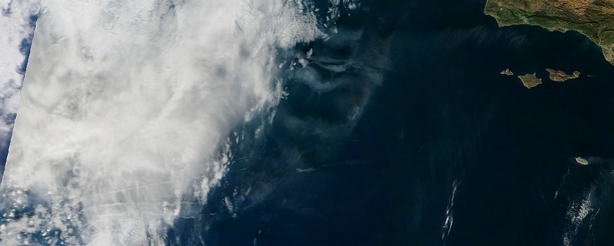
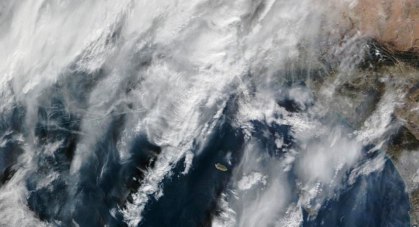
Looking at the satellite image for noon on that day (12/31/2009) and the next day (1/1/2010), we see contrails in approximately the same position, and around 100 miles long, showing it’s quite possible, given the right weather.
Really what makes this odd looking is the position of the people taking the photo. Obviously the same contrail would be visible all the way up the coast, however, the only people who thought it was really odd were those who were lined up with it, in OC. People in LA would see a dramatic looking contrail, but more obviously just a contrail, so less worthy of writing to the newspaper about. I actually saw it myself, but was in a car, and could only get a poor cell-phone snapshot:
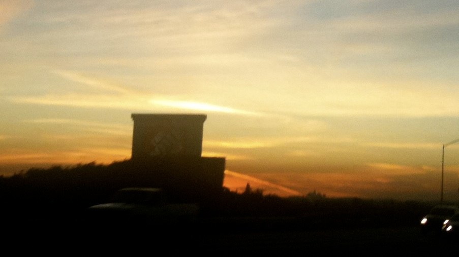
A cell-phone photo I took of the New Year Eve contrail, from an angle that shows it’s just a jet contrail
That was from somewhere around San Diamas, on the 210 freeway, so I’m looking South West, probably around 45 degrees, at the contrail, which you can only see a bit of behind the Home Depot sign. It looked quite impressive at the time. But there are other photos of it from various other angles which show it’s contrail-ness more clearly, here’s one taken from Santa Monica (click photo for original):
The actual New Years Eve contrail, viewed from Santa Monica. This is what the CBS “missile” contrail would have looked like to most people in LA, which is why nobody reported it.
You can see from this angle (and taken a bit earlier) it looks far less interesting, as it’s very apparent it’s just a contrail.
Scott Methvin sent in these two images which shows the contrail in all it’s missile-like glory but from a better angle.

The Dec 31st contrail, from Laguna Beach

Same contrail slightly later.
Here’s another angle of the New Year’s Eve contrail, this view is from Corona del Mar, about 20 miles Northeast of San Clemente:
Another angle on the New Years Eve contrail. See, it’s all about perspective.
Here’s a similar photo (of a different contrail, obviously) on the same day at the other side of the country:
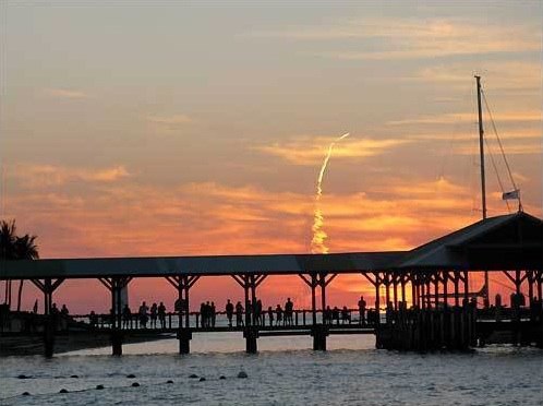
Not a missile launch.
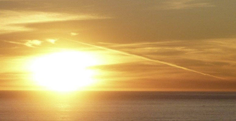
Here’s some more contrails at sunset (From a very nice set of contrail photos), note how they look exactly the same as sections of the New Year contrail:
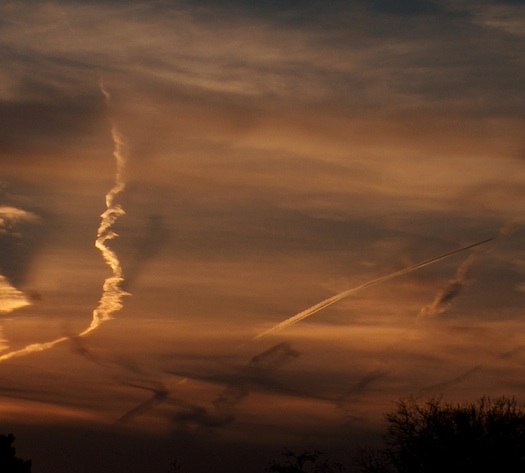
Obviously not missiles. But look at sections of the trails.
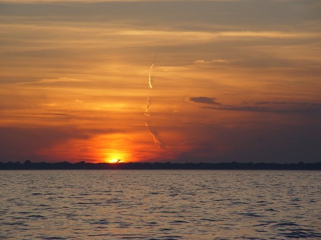
Not a missile launch, in Michigan.
[Update Nov 9 2010]
Now here’s the one everyone is actually talking about. From Monday, Nov 8th, 2010, this time it video taken a local CBS news crew in a helicopter, so they were able to zoom in.

Jet contrail, misidentified as a missile launch, again.
Note it’s pretty much in the same location. Note also it’s not exactly moving at missile speed. Note also it’s practically identical to the photos of plane contrails, above.

Same as last time, maybe even the same scheduled flight.
And once again millions of people failed to notice, because from any other angle it looked like what it was, a contrail, from a plane. Must be a slow news day, as this went all the way up to Jim Miklaszewski asking people at the pentagon about it.
There are occasional flashes of light, which I think are reflections of the sun off a flat surface on the plane. There’s also portions of the video where a bit of the trail behind the plane seems to glow. I think thats just the last rays of the setting sun lighting that portion of the trail. See Scott Methvin’s photos, above for how the trail can be oddly lit from minute to minute.
Here’s a better video. You can see after about 0:50 it’s out of the contrail-persisting region of air and is just leaving a short contrail. It’s also now out of the sun. It looks exactly like the short contrails of a jet coming towards the camera with perspective foreshortening. The camera crew lost it in the darkness shortly after that.
The most likely flight initially seemed to be US Airways flight 808 from Hawaii to Phoenix. But UPS flight 902 was also on a similar track.
http://flightaware.com/live/flight/AWE808

US Airways flight 808, at around 5PM PST (Sunset)
I snapped the above web image at around 5:05PM today, about the same time as the video was taken yesterday.
Here’s the actual track from the 8th:
http://flightaware.com/live/flight/AWE808/history/20101108/1955Z/PHNL/KPHX
And here’s a photo I took (Nov 9th) two minutes earlier from Santa Monica. I think it’s the same flight, just 24 hours later. Note that the angle is exactly the same as the Dec 31st contrail that produced the original “missile” story.

Contrail from flight 808 (verified with Google Earth and radar data). View from Santa Monica, 5:01PM
Obviously, the video would have to have been taken from way off to the right in this photo (I’m looking South West). The chopper would have been somewhere like Torrance.
[Update again]
http://latimesblogs.latimes.com/lanow/2010/11/cameraman-who-filmed-mystery-missile-describes-spectacular-sight.html
The cameraman reports:
Cameraman Gil Leyvas shot video of a luminous point hurtling through the sky followed by a long vapor trail. He said he was aboard the television station’s helicopter shooting footage of the sunset over the ocean about 5:15 p.m when he noticed the spiral-shaped vapor trail and zoomed in to get a better look.
The onboard camera showed a plume twisting up from the horizon and narrowing as it climbed into the sky near Catalina Island, about 35 miles west of Los Angeles, he said.
“Whatever it was, it was spinning up into the sky kind of like a spiral,” and was easy to distinguish from condensation trails from jets, he said. “It was quite a sight to see. It was spectacular.”
I suspect what he saw (which can only be what is on the video, I’d like to see it in HD) is the twisting of the contrails, this can be quite dramatic, especially from such a head-on angle. See this video of a similar perspective, and note the swirling twists in the contrails directly behind the jet.
http://www.youtube.com/watch?v=xl6iR7w7a_Q
Here’s a grab from that video, showing the twist, and how it as accented by the low sun.

Twisting contrails in low sun.
Liem Bahneman gives this excellent description of how flight AWE808 exactly matches the observations, including producing a near identical contrail the next day (which I also photographed, from Santa Monica, above)

This pretty much explains it.
And here are some excellent points from a real rocket scientist, posting as “Michael”:
I’d like to add to all the evidence above that it was just a jet because the plume is nothing like a rocket plume to the trained eye. I was a rocket safety inspector for 3 years, have seen countless launches and failures, and have a master’s degree in Astronautical Engineering. Here’s why it’s not a rocket:
It’s too slow (<— biggest reason).
There’s no engine flare.
There’s no expansion of the plume (as the chamber pressure exceeds the atmospheric pressure more and more during flight).
There’s no staging event.
There are no sunset striations across the plume (which would look like this: http://tinyurl.com/2vklwu5).
In the wide shot, there are two contrails (off each wing!) instead of one.
The plume at the plane is twirling in different directions (very un-rocket-like).
The plume at the plane is twirling too much — that only happens in the case of a motor burn-through, which is a failure mode, meaning it would be seconds from exploding if it were a rocket.
The wind-blown plume is all wrong, vertical plumes go through several different wind shear layers, which makes it look very different than what the video shows.
The apparent direction of the jet is a bit of an illusion, as the trail is greatly distorted by the winds at altitude, which can also vary greatly from place to place. At 37,000 feet the wind can easily be in the 50-100 mph range.
Richard Warren of Long Beach shot four close-up photos of the trail from a fixed position in Long Beach. I’ve combined them here into one photo, where you can see the trail move with the wind, and the actual path that the plane takes is much more obviously passing to the south of Long Beach, matching flight 808.
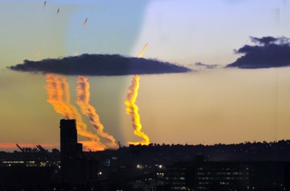
And the fact that it’s a plane is way more apparent once it stops making a contrail (which is due to it moving between two regions of air – it’s colder and/or more humid out to sea than inland)
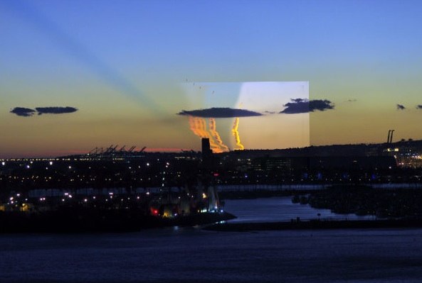
Richard took a fifth shot at a wider angle that shows the greater context. The jet is still visible as a dark speck (it’s still got a very short contrail). There’s also a very impressive crepuscular “edge” shadow that’s probably cast by part of the contrail that is over the horizon.
A couple of days later a new photo of the trail was discovered from a known time, heading and position, this allowed the location of the trail to be triangulated, and it became apparent that UPS902 was a better fit than AWE808. This video shows how the UPS trail fits with the picture above:
The UPS flight is also a better fit as it has three engines (MD-11) and hence gives a more solid contrail.
Thanks!
cleaning within a frightened toms shoes coupon code shop cool perspire cheap toms outlet from toms shoes their brow cheap toms shoes coupon code almost didn’t tumble to the ground toms shoes coupon code outlet